Mount Markham is a twin-peaked massif surmounting the north end of the Markham Plateau in the Queen Elizabeth Range of Antarctica. The peaks have elevations of 4,350 metres (14,270 ft) and 4,280 metres (14,040 ft).
The Deep Freeze Range is a rugged mountain range, over 80 nautical miles long and about 10 nautical miles wide, rising between Priestley and Campbell Glaciers in Victoria Land, Antarctica, and extending from the edge of the polar plateau to Terra Nova Bay. It is southwest of the Southern Cross Mountains, south of the Mesa Range and northeast of the Eisenhower Range of the Prince Albert Mountains.
The Mirabito Range is a narrow, northwest-trending mountain range, 64 kilometres (40 mi) long and 6 kilometres (3.7 mi) wide that lies between the upper part of Lillie Glacier and the Greenwell Glacier in northern Victoria Land, Antarctica. The range is part of the Concord Mountains.

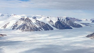
The Royal Society Range is a majestic range of mountains in Victoria Land, Antarctica, rising to 4,025 metres (13,205 ft) along the west shore of McMurdo Sound between the Koettlitz, Skelton and Ferrar Glaciers. They are south of the Kukri Hills, southeast of the Quartermain Mountains, and northeast of the Worcester Range.

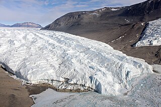
Ferrar Glacier is a glacier in Antarctica. It is about 35 nautical miles long, flowing from the plateau of Victoria Land west of the Royal Society Range to New Harbour in McMurdo Sound. The glacier makes a right (east) turn northeast of Knobhead, where it where it is apposed, i.e., joined in Siamese-twin fashion, to Taylor Glacier. From there, it continues east along the south side of Kukri Hills to New Harbor.
The Taylor Glacier is a glacier in Antarctica about 35 nautical miles long, flowing from the plateau of Victoria Land into the western end of Taylor Valley, north of the Kukri Hills. It flows to the south of the Asgard Range. The middle part of the glacier is bounded on the north by the Inland Forts and on the south by Beacon Valley.
'The Wilkniss Mountains form a prominent group of conical peaks and mountains, 10 nautical miles (19 km) long running north–south, located 9 nautical miles east-southeast of Mount Feather in the Quartermain Mountains, Victoria Land, Antarctica. The mountains are 3 nautical miles wide in the north portion where Mount Blackwelder, 2,340 metres (7,680 ft) high, and Pivot Peak 2,450 metres (8,040 ft) high, rise above ice-free valleys. Except for an outlying southwest peak, the south portion narrows to a series of mainly ice-covered smaller peaks.

The Quartermain Mountains are a group of exposed mountains in Antarctica, about 20 nautical miles long, typical of ice-free features of the McMurdo Dry Valleys, Victoria Land. They are east of the Lashly Mountains, south of the Asgard Range, west of the Kukri Hills and Royal Society Range, and some distance north of the Worcester Range.

Mount Lister is a massive mountain, 4,025 metres (13,205 ft) high, forming the highest point in the Royal Society Range of Victoria Land, Antarctica. It was discovered by the British National Antarctic Expedition (1901–1904) which named it for Lord Joseph Lister, President of the Royal Society, 1895–1900.
Briggs Hill is a conspicuous ice-free hill, 1,210 metres (3,970 ft) high, standing on the south side of Ferrar Glacier between Descent Glacier and Overflow Glacier in Victoria Land, Antarctica. It was charted by the British Antarctic Expedition, 1910–13, under Scott, and named by the United States Advisory Committee on Antarctic Names (US-ACAN) for Raymond S. Briggs, United States Antarctic Research Program meteorologist at McMurdo Station in 1962, and station scientific leader there in 1963.
The Cathedral Rocks are a series of four abrupt cliffs interspersed by short glaciers and surmounted by sharp peaks. The cliffs extend for 8 nautical miles along the south side of Ferrar Glacier and form part of the north shoulder of the Royal Society Range, in Victoria Land, Antarctica.

Kukri Hills is a prominent east-west trending range, about 25 nautical miles (46 km) long and over 2,000 metres (6,600 ft) high, forming the divide between Ferrar Glacier on the south and Taylor Glacier and Taylor Valley on the north, in Victoria Land, Antarctica. They are south of the Asgard Range, east of the Quartermain Mountains and north of the Royal Society Range.
The Mesa Range is a range of flat-topped mesas comprising the Sheehan, Pain, Tobin and Gair Mesas, situated at the head of the Rennick Glacier in Victoria Land, Antarctica. It was given this descriptive name by the northern party of the New Zealand Geological Survey Antarctic Expedition (NZGSAE) of 1962–63.
Hobbs Ridge is a prominent arc-shaped ridge which circumscribes Hobbs Glacier to the north and northwest and forms the divide with the lower part of Blue Glacier, on the Scott Coast of Victoria Land, Antarctica. It was named in association with Hobbs Glacier. It forms the northernmost part of the Denton Hills.

Mackay Glacier is a large glacier in Victoria Land, descending eastward from the Antarctic Plateau, between the Convoy Range and Clare Range, into the southern part of Granite Harbour. It was discovered by the South magnetic pole party of the British Antarctic Expedition, 1907–09, and named for Alistair Mackay, a member of the party. The glacier's tongue is called Mackay Glacier Tongue. First mapped by the British Antarctic Expedition, 1910–13 and named for Alistair F. Mackay, a member of the party. Its mouth is south of the Evans Piedmont Glacier and the Mawson Glacier. It is north of the Wilson Piedmont Glacier and the Ferrar Glacier.
Saint Johns Range is a crescent-shaped mountain range about 20 nautical miles long, in Victoria Land, Antarctica. It is bounded on the north by the Cotton Glacier, Miller Glacier and Debenham Glacier, and on the south by Victoria Valley and the Victoria Upper Glacier and Victoria Lower Glacier.
Snake Ridge is a serpentine ridge, 4 nautical miles long, adjoining the northwest extremity of Mackin Table in the Patuxent Range, Pensacola Mountains.
Rampart Ridge is a prominent broken ridge on the west side of the Royal Society Range, Antarctica. It stands north of Rutgers Glacier and extends from The Spire to Bishop Peak.
Blue Glacier is a large glacier which flows into Bowers Piedmont Glacier about 10 nautical miles south of New Harbour, in Victoria Land, Antarctica. It was discovered by the British National Antarctic Expedition (BrNAE) under Robert Falcon Scott, 1901–04, who gave it this name because of its clear blue ice at the time of discovery.
Mount Rücker is a mountain, 3,815 metres (12,516 ft) high, immediately south of Johns Hopkins Ridge, in the Royal Society Range, Victoria Land, Antarctica. It was discovered by the British National Antarctic Expedition which named it for Sir Arthur Rucker, Honorary Secretary of the Royal Society.