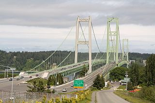
The Tacoma Narrows Bridge is a pair of twin suspension bridges that span the Tacoma Narrows strait of Puget Sound in Pierce County, Washington. The bridges connect the city of Tacoma with the Kitsap Peninsula and carry State Route 16 over the strait. Historically, the name "Tacoma Narrows Bridge" has applied to the original bridge nicknamed "Galloping Gertie", which opened in July 1940, but collapsed possibly because of aeroelastic flutter four months later, as well as the replacement of the original bridge which opened in 1950 and still stands today as the westbound lanes of the present-day 2 bridge complex.

Gig Harbor is the name of both a bay on Puget Sound and a city on its shore in Pierce County, Washington, United States. The population was 12,026 at the 2020 census, up from 7,126 in 2010.

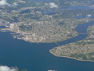
Tacoma is the county seat of Pierce County, Washington, United States. A port city, it is situated along Washington's Puget Sound, 32 miles (51 km) southwest of Seattle, 31 miles (50 km) northeast of the state capital, Olympia, and 58 miles (93 km) northwest of Mount Rainier National Park. The population was 219,346, according to the 2020 census. Tacoma is the second-largest city in the Puget Sound area and the third-largest in the state. Tacoma also serves as the center of business activity for the South Sound region, which has a population of about 1 million.

The 1940 Tacoma Narrows Bridge, the first Tacoma Narrows Bridge, was a suspension bridge in the U.S. state of Washington that spanned the Tacoma Narrows strait of Puget Sound between Tacoma and the Kitsap Peninsula. It opened to traffic on July 1, 1940, and dramatically collapsed into Puget Sound on November 7 the same year. The bridge's collapse has been described as "spectacular" and in subsequent decades "has attracted the attention of engineers, physicists, and mathematicians". Throughout its short existence, it was the world's third-longest suspension bridge by main span, behind the Golden Gate Bridge and the George Washington Bridge.
Tacoma Community College (TCC) is a public community college in Tacoma, Washington with satellite operations in Gig Harbor and the Bridge Program in partnership with The Evergreen State College. It serves the city of Tacoma and the Pierce County portion of the Kitsap Peninsula.

The Kitsap Peninsula lies west of Seattle across Puget Sound, in Washington state in the Pacific Northwest. Hood Canal separates the peninsula from the Olympic Peninsula on its west side. The peninsula, a.k.a. "Kitsap", encompasses all of Kitsap County except Bainbridge and Blake Islands, as well as the northeastern part of Mason County and the northwestern part of Pierce County. The highest point on the Kitsap Peninsula is Gold Mountain. The U.S. Navy's Puget Sound Naval Shipyard, and Naval Base Kitsap are on the peninsula. Its main city is Bremerton.
State Route 16 (SR 16) is a 27.16-mile-long (43.71 km) state highway in the U.S. state of Washington, connecting Pierce and Kitsap counties. The highway, signed as east–west, begins at an interchange with Interstate 5 (I-5) in Tacoma and travels through the city as a freeway towards the Tacoma Narrows. SR 16 crosses the narrows onto the Kitsap Peninsula on the partially tolled Tacoma Narrows Bridge and continues through Gig Harbor and Port Orchard before the freeway ends in Gorst. The designation ends at an intersection with SR 3 southwest of the beginning of its freeway through Bremerton and Poulsbo. SR 16 is designated as a Strategic Highway Network (STRAHNET) corridor within the National Highway System as the main thoroughfare connecting Tacoma to Naval Base Kitsap and a part of the Highways of Statewide Significance program.
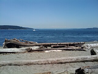
Titlow Beach is in Tacoma, Washington, USA. It is located along Puget Sound near the Tacoma Narrows Bridge. It has a beach, community center, park, water play area, two restaurants., a view of the Tacoma Narrows Bridge, a small boardwalk, and is a popular scuba diving area.

The Third Lake Washington Bridge, officially the Homer M. Hadley Memorial Bridge, is a floating bridge in the Seattle metropolitan area of the U.S. state of Washington. It is one of the Interstate 90 floating bridges, carrying the westbound lanes of Interstate 90 across Lake Washington between Mercer Island and Seattle. The floating bridge is the fifth-longest of its kind in the world, at 5,811 feet.
The Port Washington Narrows is a tidal strait located in Bremerton, Washington, United States. The northwest entrance is marked on the west side by Rocky Point, and the southeast entrance is located at Point Turner on the west side and Point Herron on the east side. It is located between downtown Bremerton and the Manette Peninsula.

The Washington House of Representatives is the lower house of the Washington State Legislature, and along with the Washington State Senate makes up the legislature of the U.S. state of Washington. It is composed of 98 Representatives from 49 districts, each of which elects one Senator and two members of the House. They are elected to separate positions with the top-two primary system. All members of the House are elected to a two-year term without term limits. The House meets at the State Capitol in Olympia.
Peyton Field at Baker Stadium is a 3,500-seat stadium located on the campus of the University of Puget Sound in the North End of Tacoma, Washington.
Dalco Passage is a tidal strait within Puget Sound in the U.S. state of Washington. Located between the southern end of Vashon Island and the mainland near Tacoma, Dalco Passage connects the northern main Puget Sound basin to the southern basin, via the Tacoma Narrows strait. Colvos Passage, Commencement Bay, and Quartermaster Harbor are also connected to Dalco Passage.

The Murray Morgan Bridge, also known as the 11th Street Bridge or City Waterway Bridge, is a vertical-lift bridge in Tacoma, Washington. It originally opened Feb. 15, 1913 to replace an 1894 swing-span bridge. The bridge connects downtown with the tideflats, it spans the Thea Foss Waterway, originally known as the City Waterway. Designed by noted bridge engineering firm Waddell & Harrington, the bridge has some unusual features: higher above the water than most lift bridges, construction on a variable grade and an overhead span designed to carry a water pipe. The bridge structure also contained a series of switchback ramps that connected what is now Cliff Street with Dock Street. According to the Department of Transportation, the towers are 207' 13⁄4" (63.14 m) above the water, with the road deck 60' above the water level at zero tide. It was modified and updated in 1957 and was used to route State Route 509 through the tideflats. The bridge was bypassed in the late 1990s when State Route 509 was routed around the edge of the tideflats. While WSDOT wanted to tear down the bridge, the City of Tacoma convinced the state to transfer ownership to the City. In the past, the bridge has been heavily used by commuters and emergency services in connecting the Port of Tacoma with downtown Tacoma.
MultiCare Health System's Tacoma General Hospital is the largest hospital in Tacoma, Washington. It is a level II trauma center with 437 beds and the second largest obstetrical care center in the state of Washington. Tacoma General began serving patients in 1882. The hospital is owned and operated by MultiCare Health System, a Tacoma-based not-for-profit integrated health organization.

The Puget Sound region is a coastal area of the Pacific Northwest in the U.S. state of Washington, including Puget Sound, the Puget Sound lowlands, and the surrounding region roughly west of the Cascade Range and east of the Olympic Mountains. It is characterized by a complex array of saltwater bays, islands, and peninsulas carved out by prehistoric glaciers.

The 1950 Tacoma Narrows Bridge is a suspension bridge in the U.S. state of Washington that carries the westbound lanes of Washington State Route 16 across the Tacoma Narrows strait, between the city of Tacoma and the Kitsap Peninsula. Opened on October 14, 1950, it was built in the same location as the original Tacoma Narrows Bridge, which collapsed due to a windstorm on November 7, 1940. It is the older of the twin bridges that make up the Tacoma Narrows Bridge crossing of the Tacoma Narrows, and carried both directions of traffic across the strait until 2007. At the time of its construction, the bridge was, like its predecessor, the third-longest suspension bridge in the world in terms of main span length, behind the Golden Gate Bridge and George Washington Bridge; it is now the 46th longest suspension bridge in the world.

Fairfax was a coal town in Pierce County in the U.S. state of Washington. Mining lasted only until the minerals ceased to be economically viable following World War I. Until the completion of the nearby 240 feet (73 m) high Farrell Bridge in 1921, the town was only accessible via railroad or pack train.
The Seattle Air Route Traffic Control Center is the area control center responsible for controlling and ensuring proper separation of IFR aircraft in Washington state, most of Oregon, and parts of Idaho, Montana, Nevada, and California, as well as the neighboring area into the Pacific Ocean.
The Nisqually Reach is a portion of Puget Sound south of the Tacoma Narrows, near the exit of the Nisqually River into the Sound. It is classified as a bay by the United States government. It was originally defined as "the portion of the Sound lying between Anderson Island and the mainland".


