
The White Pass and Yukon Route is a Canadian and U.S. Class II 3 ft narrow-gauge railroad linking the port of Skagway, Alaska, with Whitehorse, the capital of Yukon. An isolated system, it has no direct connection to any other railroad. Equipment, freight and passengers are ferried by ship through the Port of Skagway, and via road through a few of the stops along its route.
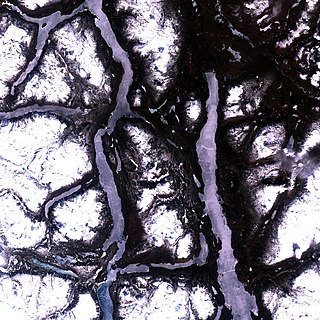
Atlin Lake is the largest natural lake in the Canadian province of British Columbia. The northern tip of the lake is in Yukon, as is Little Atlin Lake. However, most of the lake lies within the Atlin District of British Columbia. Atlin Lake is believed to be the source of the Yukon River although it is drained via the short Atlin River into Tagish Lake.

Atlin Provincial Park and Recreation Area is a provincial park in British Columbia, Canada. Situated in the remote northwestern corner of the province, the park protects large tracts of boreal forest, alpine tundra and glaciated terrain. The southern third of Atlin Lake, the largest natural body of freshwater in the province, is within the park boundary. The park is very undeveloped; no roads traverse it and no facilities, supplies, developed campsites or maintained hiking trails are available inside the park. The area has become a focal point in controversies involving proposed hydroelectric projects affecting Atlin Lake and environmental groups who view these proposals as potentially damaging to the lake's environment and its surroundings.

Atlin is a community in northwestern British Columbia, Canada, located on the eastern shore of Atlin Lake. In addition to continued gold-mining activity, Atlin is a tourist destination for fishing, hiking and Heliskiing. As of 2004, there are 450 permanent residents.

The Tagish Highland is an upland area on the inland side of the northernmost Boundary Ranges of the Coast Mountains, spanning far northwestern British Columbia from Atlin Lake to the area of the pass at Champagne, Yukon between the Alsek and Yukon Rivers. In some classification systems, and in local terminology, the Tagish Highland is considered to be part of the Boundary Ranges, as is the neighbouring Tahltan Highland to its south. As classified by the Canadian Mountain Encyclopedia per S. Holland, the Tagish Highland is part of the system unofficially described as the Interior Mountains.

The Stikine Country, also referred to as the Stikine District or simply "the Stikine", is one of the historical geographic regions of the Canadian province of British Columbia, located inland from the central Alaska Panhandle and comprising the basin of the Stikine River and its tributaries. The term Stikine–Iskut is also fairly common to describe the area, and references the Iskut River, the Stikine's largest tributary and describable as its south fork.
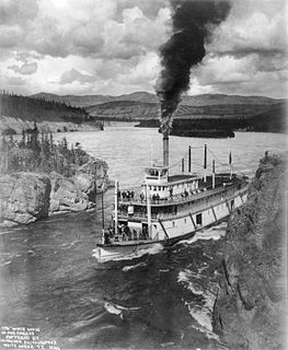
Steamboats on the Yukon River played a role in the development of Alaska and Yukon. Access to the interior of Alaska and Yukon was hindered by large mountains and distance, but the wide Yukon River provided a feasible route. The first steamers on the lower Yukon River were work boats for the Collins Overland Telegraph in 1866 or 1867, with a small steamer called Wilder. The mouth of the Yukon River is far to the west at St. Michael and a journey from Seattle or San Francisco covered some 4,000 miles (6,400 km).
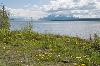
Teslin Lake is a large lake spanning the border between British Columbia and Yukon, Canada. It is one of a group of large lakes in the region of far northwestern BC, east of the upper Alaska Panhandle, which are the southern extremity of the basin of the Yukon River, and which are known in Yukon as "the Southern Lakes". The lake is fed and drained primarily by the Teslin River, south and north, but is also fed from the east by the Jennings River and the Swift River, and from the west by the Hayes River.
The Nakina River is a river in northwestern British Columbia, Canada, rising southeast of Atlin Lake and flowing generally southeast to its confluence with the Inklin River at the locality of Inklin, where the two rivers combine to form the Taku River.
The Taku River Tlingit First Nation are the band government of the Inland Tlinkit in far northern British Columbia, Canada and also in Yukon. They comprise two ḵwaan (tribes) of the Tlingit people, who are otherwise coastal, the Áa Tlein Ḵwáan of the Atlin Lake area and the Deisleen Ḵwáan of Teslin Lake, whose main focus is the Teslin Tlingit Council in Teslin, Yukon. Their band offices are in Atlin, British Columbia.
Steamboats operated on the Stikine River in response to gold finds in along that river and in the Cassiar Country of northwestern British Columbia, Canada.

The Stikine Region is an unincorporated area in northwesternmost British Columbia, Canada and is the only area in B.C. not in a regional district. The Stikine Region was left unincorporated following legislation that established the province's regional districts in 1968 and is not classified as a regional district. It contains no municipal governments which normally constitute the majority of seats on the boards of regional districts. There is only one local planning area, the Atlin Community Planning Area, which was combined in 2009 with the Atlin Community Improvement District to provide fire, landfill, water, streetlighting, sidewalks and advisory land use services. All other services not provided privately are administered directly by various provincial government ministries. The area around Dease Lake, formerly in the Stikine Region, is now within the boundaries of the Regional District of Kitimat-Stikine following a boundary amendment in 2008.

Atlin Mountain, at 6,712 feet (2,046 m), is a medium-sized mountain located next to Atlin Lake in the northern end of the Coast Mountain range in British Columbia, Canada. It is home to the Atlin Mountain Challenge and Snow Drags snowmobile event and the Atlin Mountain Hill Climb.
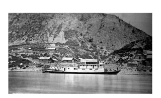
Ben-My-Chree is a famous former hunting and fishing lodge, steamboat landing and small resort in Northern British Columbia, Canada. It is located at the southwest end of Taku Arm, Tagish Lake in the Atlin District in the extreme northwest of the province, and is closer to the Yukon than the rest of the province. The Wall Street Crash of 1929 and Great Depression began the resort's decline and it closed in 1956. The site is now a private residence being reclaimed by wilderness.
King Salmon Creek is a creek in the Atlin District of British Columbia, Canada. The creek begins at King Salmon Lake and flows generally eastward to join the Taku River. Southeast of that confluence is King Salmon Mountain.
The Atlin Arts & Music Festival (AAMF) is an annual arts and music festival directed towards families located in Atlin, British Columbia that happens every July since 2003, however no festival took place in 2010 due to lack of funding. The festival has hosted acts such as Michelle Wright, Sloan, Delhi 2 Dublin, Iskwé, Rock Plaza Central, Harpoonist & The Axe Murderer, The Olympic Symphonium, Matt Epp, David Francey, & many more performers. It also has a large variety of visual artists who invite you to participate in art & music workshops & demos, comedy, artist exhibitions, dance, storytelling, and some workshops even aimed towards children. The annual "Atlin Mini-Marathon" is also strategically held during the Festival weekend.

