Related Research Articles
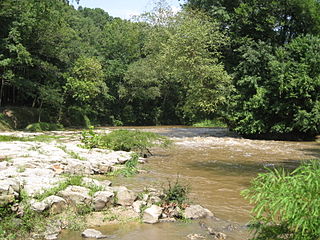
The Strong River is a 95.2-mile-long (153.2 km) river in south-central Mississippi in the United States. It is a tributary of the Pearl River, which flows to the Gulf of Mexico.
Bogue Ealiah is a stream in the U.S. state of Mississippi. It is a tributary to Tallahala Creek.
Bogue Homo is a stream in the U.S. state of Mississippi. It is a tributary to the Leaf River.
Choctaw Creek is a stream in the U.S. state of Mississippi. It is a tributary to Holiday Creek.
Cohay is an unincorporated community in Smith County, in the U.S. state of Mississippi.
Conehoma Creek is a stream in the U.S. state of Mississippi.
Coonshuck Creek is a stream in the U.S. state of Mississippi.
Cushtusia Creek is a stream in the U.S. state of Mississippi.
Etehomo Creek is a stream in the U.S. state of Mississippi.
Hatchapaloo Creek is a stream in the U.S. state of Mississippi. It is a tributary to Oakohay Creek.
Lobutcha Creek is a stream in the U.S. state of Mississippi. It is a tributary to the Pearl River.
Nuakfuppa Creek is a stream in the U.S. state of Mississippi.
Oakohay Creek is a stream in the U.S. state of Mississippi.
Ocobla is an unincorporated community in Neshoba County, in the U.S. state of Mississippi.
Otak Creek is a stream in the U.S. state of Mississippi.
Tallahala Creek is a stream in the U.S. state of Mississippi.
Tallahoma Creek is a stream in the U.S. state of Mississippi.
Tibbehoy Creek is a stream in the U.S. state of Mississippi.
South Tippah Creek is a stream in the U.S. state of Mississippi. It joins with North Tippah Creek to form the Tippah River.
Tuscola is an unincorporated community in Leake County, in the U.S. state of Mississippi.
References
- 1 2 U.S. Geological Survey Geographic Names Information System: Tallahattah Creek
- ↑ Baca, Keith A. (2007). Native American Place Names in Mississippi. University Press of Mississippi. p. 103. ISBN 978-1-60473-483-6.
Coordinates: 31°51′11″N89°05′54″W / 31.8529347°N 89.0983894°W
| This article related to a river in Mississippi is a stub. You can help Wikipedia by expanding it. |