Jakarta, officially the Special Capital Region of Jakarta and formerly known as Batavia until 1949, is the nation's capital city and the centre of the largest metropolis of Indonesia. Lying on the northwest coast of Java, the world's most populous island, Jakarta is the largest metropole in Southeast Asia, and serves as the diplomatic capital of ASEAN. Jakarta is bordered by two provinces: West Java to the south and east; and Banten to the west. The Special Capital Region has a status equivalent to that of a province. Its coastline faces the Java Sea to the north, and it shares a maritime border with Lampung to the west. Jakarta's metropolitan area is ASEAN's second largest economy after Singapore.

Malang, historically known as Tumapel, is an inland city in the Indonesian province of East Java. It has a history dating back to the age of the Singhasari Kingdom. It is the second most populous city in the province, with a population of 820,043 at the 2010 Census and 843,810 at the 2020 Census; the official estimate as of mid-2023 was 847,182. The Malang Metropolitan area was home to 3,663,691 inhabitants in 2010, spread across two cities and 22 districts. Malang is the third largest city by economy in East Java, after Surabaya and Kediri, with an estimated 2016 GDP at Rp. 44.30 trillion.

Gelora Bung Karno Main Stadium, formerly Senayan Main Stadium and Gelora Senayan Main Stadium, is a multi-purpose stadium located at the center of the Gelora Bung Karno Sports Complex in Central Jakarta, Indonesia. It is mostly used for football matches, and usually used by the Indonesia national football team and Liga 1 club Persija Jakarta. The stadium is named after Sukarno, the then-president of Indonesia, who sparked the idea of building the sports complex.

Menteng is a district in the administrative city of Central Jakarta, Indonesia. Menteng is surrounded by the districts of Senen and Matraman to the east, Tebet and Setiabudi to the south, Tanah Abang to the west, and Gambir to the north. Menteng is bound by the West Flood Canal to the west, Ciliwung River to the south and east, and Kebon Sirih Road to the north. Menteng is the district seat of the Central Jakarta government.
Pluit is an administrative village (kelurahan) located in Penjaringan, Jakarta. In majority, of its residents are mainly inhabited by ethnic Chinese Indonesians. Pluit is a bustling area with residential and commercial establishments supported by modern amenities.

Kebayoran Baru is a district in the administrative city of South Jakarta, Indonesia. The name was derived from a planned satellite city of the same name which was developed in the post-war period. Kebayoran Baru was the last residential area to be developed by the Dutch colonial administration. The urban planning was laid in a concept of the Garden city movement, consisting of a well-planned residential area, a shopping center, and a business district, supported with civic facilities such as schools, places of worship, hospitals, and parks. Today, the district is home to many important government institutions, such as the Indonesia Stock Exchange building, the ASEAN Headquarters building, the National Police headquarters, and the City Hall of South Jakarta. Sudirman Central Business District is also located in the district.

Merdeka Square is a large square located in the center of Jakarta, Indonesia. Merdeka is the Indonesian word for freedom or independence. Measuring approximately one square kilometer in area, if the surrounding fields within the Merdeka Square are included, it is considered one of the largest squares in the world. At 75 hectares, it is over five times the size of Tiananmen Square, and 12 times the size of Place de la Concorde.

Colonial buildings and structures in Jakarta include those that were constructed during the Dutch colonial period of Indonesia. The period succeeded the earlier period when Jakarta, governed by the Sultanate of Banten, were completely eradicated and replaced with a walled city of Batavia. The dominant styles of the colonial period can be divided into three periods: the Dutch Golden Age, the transitional style period, and Dutch modernism. Dutch colonial architecture in Jakarta is apparent in buildings such as houses or villas, churches, civic buildings, and offices, mostly concentrated in the administrative city of Central Jakarta and West Jakarta.
Kwitang is an administrative village (kelurahan) in the subdistrict (kecamatan) of Senen, Central Jakarta. It is one of the historic administrative village of Jakarta. The boundary of Kwitang is the Ciliwung to the west, Jalan Kramat Kwitang to the north, Jalan Kramat Raya to the east, and Jalan Kramat 4 to the south.
The following is a timeline of the history of the city of Jakarta, Indonesia.
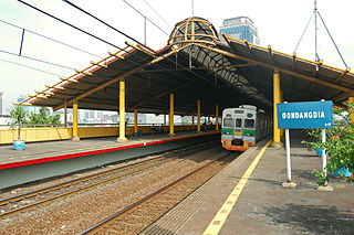
Gondangdia Station (GDD) is a railway station serving by Jakarta Commuterline at Gondangdia, Menteng, Central Jakarta, Indonesia.
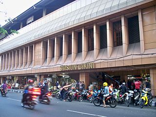
Cikini Station is a railway station located on Jl. Cikini Raya, Cikini, Menteng, Jakarta. This station is only served by KRL Commuterline commuter trains from Jakarta Kota to Depok and Bogor.

Jakarta City Hall is the seat of the Jakarta City government. The complex contains the official office of the governor and the vice governor of Jakarta, and the main administrative office. Jakarta City Hall is located south of Merdeka Square.
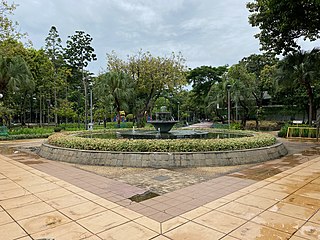
Menteng Park is a park located at Menteng, Central Jakarta, Indonesia. This park was formerly occupied by Menteng Stadium. In October 2006 the stadium was demolished and the park was built on the area by the administration of Sutiyoso. The park is located at the center of Menteng residential area. At present it is one of the popular park in Jakarta.
Sunter is a neighborhood in North Jakarta, Indonesia. The neighborhood corresponds roughly with the Sunter Agung and Sunter Jaya administrative village of Tanjung Priok subdistrict of North Jakarta. Zip code of the area is 14350. The area is adjacent to Plumpang Semper in the north, Kemayoran in the west, Kelapa Gading in the east and Cempaka Mas in the south. The area probably named after Sunter River, which flows through the neighborhood. The area is a low terrain and prone to flooding during heavy rain.

The Krukut River is a river flowing in Jakarta originating in Bogor Regency. In the past the river was clean and one of the tourist attractions during the Dutch East Indies administration, but due to denser housing on the banks and lack of maintenance, the water turned dark and filled with trash, causing routine flooding in rainy seasons.
The Baru Barat River is a man-made canal flowing from the Cisadane River in Bogor Regency to Jakarta, Indonesia. It was one of two canals built in the 18th century under the order of the Governor-General Gustaaf Willem van Imhoff, the other being the Baru Timur River. Both canals were originally built to transport agricultural harvests from Bogor to Batavia. They are among the main rivers in Jakarta, and part of the Ciliwung Cisadane flood control project. The Baru Barat River flows through the districts of Pancoran and Tebet in South Jakarta and drains into the Banjir Kanal Barat.
The following outline is provided as an overview of and topical guide to Jakarta:
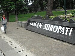
Situ Lembang Park is a park located at Menteng, Jakarta, Indonesia. Situ means lake, while Lembang is the name of the road adjacent the park. The park is nestled within houses of Menteng residential area and located close to another park Taman Suropati.

Dukuh Atas TOD is a transit-oriented development area between Central Jakarta and South Jakarta, Indonesia. This is built as part of constructing several other transit oriented development across Jakarta to facilitate commuters to transfer between different mode of public transportation.