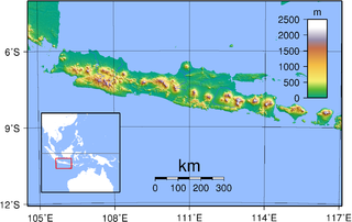
The history of Indonesia has been shaped by its geographic position, its natural resources, a series of human migrations and contacts, wars and conquests, as well as by trade, economics and politics. Indonesia is an archipelagic country of 17,000 to 18,000 islands stretching along the equator in South East Asia. The country's strategic sea-lane position fostered inter-island and international trade; trade has since fundamentally shaped Indonesian history. The area of Indonesia is populated by peoples of various migrations, creating a diversity of cultures, ethnicities, and languages. The archipelago's landforms and climate significantly influenced agriculture and trade, and the formation of states. The boundaries of the state of Indonesia represent the 20th century borders of the Dutch East Indies.
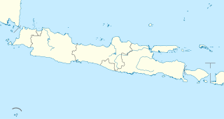
The Provinces of Indonesia are the 34 largest subdivisions of the country and the highest tier of the local government. Provinces are further divided into regencies and cities, which are in turn subdivided into districts (kecamatan).

West Java is a province of Indonesia on the western part of the island of Java, with its provincial capital in Bandung. West Java is bordered by the province of Banten and the country's capital region of Jakarta to the west, the Java Sea to the north, the province of Central Java to the east and the Indian Ocean to the south. The province is the homeland of the Sundanese people, the second-largest ethnic group in Indonesia after the Javanese. West Java was one of the early eight provinces of Indonesia formed following the country's independence proclamation and was later legally re-established on July 14, 1950.
Central Java is a province of Indonesia, located in the middle of the island of Java. Its administrative capital is Semarang. It is bordered by West Java in the west, the Indian Ocean and the Special Region of Yogyakarta in the south, East Java in the east, and the Java Sea in the north. It has a total area of 32,548 km², with a population of 33 million in 2015, making it the third-most populous province in both Java and Indonesia after West Java and East Java. The province also includes the island of Nusakambangan in the south, and the Karimun Jawa Islands in the Java Sea. Central Java is also a cultural concept that includes the Special Region and city of Yogyakarta. However, administratively the city and its surrounding regencies have formed a separate special region since the country's independence, and is administrated separately. Although known as the "heart" of Javanese culture, there are several other non-Javanese ethnic groups, such as the Sundanese on the border with West Java. Chinese Indonesians, Arab Indonesians, and Indian Indonesians are also scattered throughout the province.

Tangerang is a city in the province of Banten, Indonesia. Located on the western border of Jakarta, it is the third largest urban centre in the Greater Jakarta metropolitan area after Jakarta and Bekasi; the sixth largest city proper in the nation; and the largest city in Banten province. It has an area of 164.54 square kilometres and an official 2010 Census population of 1,798,601, which had risen to 2,043,213 at the 2015 Intermediate Census. The latest official estimate as at mid 2019 is 2,237,006 – making it the eighth most populated suburb in the world at the latter date.
Sukabumi is a city surrounded by the regency of the same name in the southern foothills of Mount Gede, in West Java, Indonesia, about 100 km (62 mi) south of the national capital, Jakarta
Tasikmalaya Regency is a regency in the province of West Java, Indonesia. It covers an area of 2,712.52 km2, and had a population of 1,675,675 at the 2010 Census; the latest official estimate was 1,876,544. Located in the southeastern region of Priangan (Preanger), the Regency is by far the biggest and the most important regency in East Preanger. The Regency was previously administered from Tasikmalaya City, which however is now administratively independent of the Regency, and the administrative centre of the Regency is now at Singaparna to the west of the city.

Bengkulu is the capital of the Indonesian province of Bengkulu. The city is the second largest city on the west coast of Sumatra Island after Padang. Previously this area is under the influence of the kingdom of Inderapura and the Sultanate of Banten. The city also became the exile of Sukarno during the period of 1939 - 1942. It had a population of 308,756 at the 2010 Census, the latest estimate is 328,827. The city is also the largest city of Bengkulu Province.

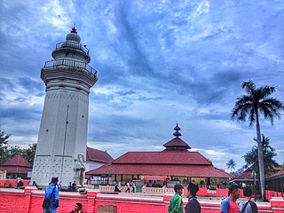
The Banten Sultanate was founded in the 16th century and centred in Banten, a port city on the northwest coast of Java; the contemporary English spelling of both was Bantam. It is said to have been founded by Sunan Gunungjati, who had previously founded Cirebon.

Serang municipality is the capital of Banten province and was formerly also the administrative center of Serang Regency in Indonesia. The city is located towards the north of Banten province, on the island of Java. Before Banten province was formed in 2000 Serang was part of West Java province.

Jakarta is Indonesia's capital and largest city. Located on an estuary of the Ciliwung River, on the northwestern part of Java, the area has long sustained human settlement. Historical evidence from Jakarta dates back to the 4th century CE, when it was a Hindu settlement and port. The city has been sequentially claimed by the Indianized kingdom of Tarumanegara, the Hindu Kingdom of Sunda, the Muslim Sultanate of Banten, and by Dutch, Japanese and Indonesian administrations. The Dutch East Indies built up the area before it was taken during World War II by the Empire of Japan and finally became independent as part of Indonesia.

The Bantenese are a distinct subgroup of the Sundanese people, native to Banten Province on the island of Java. The area of Banten province corresponds more or less with the area of the former Banten Sultanate, a Banten nation state that precedes Indonesia. In his book "The Sultanate of Banten", Guillot Claude writes on page 35: “These estates, owned by the Bantenese of Chinese origin, were concentrated around the village of Kelapadua.” Most of Bantenese are Sunni Muslim.
Sejarah Banten is a Javanese chronicle containing stories of conversion to Islam in Indonesia. The manuscripts of the chronicle date from the late nineteenth century, although two are known to be copies written from the originals in the 1730s and 1740s.
The Dutch East India Company had a presence in the Malay archipelago from 1603, when the first trading post was established, to 1800, when the bankrupt company was dissolved, and its possessions nationalised as the Dutch East Indies.

Ci Durian, or Ci Kandi, is a river in the Banten province of western Java, Indonesia. It rises in the mountains to the south and flows north to the Java Sea. The delta of the river, now canalized, has long been used for rice paddies and for a period was also used for sugarcane plantations. Extensive irrigation works diverted water from the river into a canal system in the 1920s, but these works were not completed and suffered from neglect in the post-colonial era. Plans were made in the 1990s to rehabilitate the irrigation works and dam the river to provide water for industrial projects, with Dutch and Japanese assistance, but these were cancelled by the Indonesian government.
French and British interregnum in the Dutch East Indies were a relatively short period of French and followed by British interregnum on the Dutch East Indies that took place between 1806 and 1815. The French ruled between 1806 and 1811. The British took over for 1811 to 1815, and transferred its control back to the Dutch in 1815.