
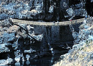
The Inca road system was the most extensive and advanced transportation system in pre-Columbian South America. It was about 40,000 kilometres (25,000 mi) long. The construction of the roads required a large expenditure of time and effort.

Juliaca is the capital of San Román Province in the Puno Region of southeastern Peru. It is the region's largest city with a population of 276,110 inhabitants (2017). On the Altiplano, Juliaca is 3,825 metres (12,549 ft) above sea level, is located on the Collao Plateau and is northwest of Lake Titicaca (45 km). It is the largest trade center in the Puno region.
Cahuachi, in Peru, was a major ceremonial center of the Nazca culture, based from about 1–500 CE in the coastal area of Peru's central Andes. It overlooked some of the Nazca lines. The Italian archaeologist Giuseppe Orefici has been excavating at the site for the past few decades. The site contains over 40 mounds topped with adobe structures. The huge architectural complex covers 0.6 sq. miles (1.5 km²) at 365 meters above sea level. The American archeologist Helaine Silverman has also conducted long term, multi-stage research and written about the full context of Nazca society at Cahuachi, published in a lengthy study in 1993.
The Nazca culture was the archaeological culture that flourished from c. 100 BC to 800 AD beside the arid, southern coast of Peru in the river valleys of the Rio Grande de Nazca drainage and the Ica Valley. Strongly influenced by the preceding Paracas culture, which was known for extremely complex textiles, the Nazca produced an array of crafts and technologies such as ceramics, textiles, and geoglyphs.
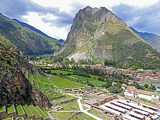
Ollantaytambo is a town and an Inca archaeological site in southern Peru some 72 km (45 mi) by road northwest of the city of Cusco. It is located at an altitude of 2,792 m (9,160 ft) above sea level in the district of Ollantaytambo, province of Urubamba, Cusco region. During the Inca Empire, Ollantaytambo was the royal estate of Emperor Pachacuti, who conquered the region, and built the town and a ceremonial center. At the time of the Spanish conquest of Peru, it served as a stronghold for Manco Inca Yupanqui, leader of the Inca resistance. Located in the Sacred Valley of the Incas, it is now an important tourist attraction on account of its Inca ruins and its location en route to one of the most common starting points for the four-day, three-night hike known as the Inca Trail.

The Chincha culture was the culture of a Native Peruvian people living near the Pacific Ocean in south west Peru. The Chincha Kingdom and their culture flourished in the Late Intermediate Period, also known as the regional states period of pre-Columbian Peru. They became part of the Inca Empire around 1480. They were prominent as sea-going traders and lived in a large and fertile oasis valley. La Centinela is an archaeological ruin associated with the Chincha. It is located near the present-day city of Chincha Alta.

Inca architecture is the most significant pre-Columbian architecture in South America. The Incas inherited an architectural legacy from Tiwanaku, founded in the 2nd century B.C.E. in present-day Bolivia. A core characteristic of the architectural style was to use the topography and existing materials of the land as part of the design. The capital of the Inca empire, Cuzco, still contains many fine examples of Inca architecture, although many walls of Inca masonry have been incorporated into Spanish Colonial structures. The famous royal estate of Machu Picchu is a surviving example of Inca architecture. Other significant sites include Sacsayhuamán and Ollantaytambo. The Incas also developed an extensive road system spanning most of the western length of the continent and placed their distinctive architecture along the way, thereby visually asserting their imperial rule along the frontier.
The Inca society was the society of the Inca civilization in Peru. The Inca Empire, which lasted from 1438 to 1533 A.D., represented the height of this civilization. The Inca state was known as the Kingdom of Cusco before 1438. Over the course of the empire, the rulers used conquest and peaceful assimilation to incorporate a large portion of western South America, centered on the Andes mountain ranges. The empire proved relatively short-lived however: by 1533, Atahualpa, the last Sapa Inca (emperor) of the Inca Empire, was killed on the orders of the conquistador Francisco Pizarro, marking the beginning of Spanish rule. The last Inca stronghold, the Neo-Inca State in Vilcabamba, was conquered by the Spanish in 1572.

Choquequirao is an Incan site in southern Peru, similar in structure and architecture to Machu Picchu. The ruins are buildings and terraces at levels above and below Sunch'u Pata, the truncated hill top. The hilltop was anciently leveled and ringed with stones to create a 30 by 50 m platform.
Inca technology includes devices, technologies and construction methods used by the Inca people of western South America, including the methods Inca engineers used to construct the cities and road network of the Inca Empire.
A tambo was an Inca structure built for administrative and military purposes. Found along the extensive roads, tambos typically contained supplies, served as lodging for itinerant state personnel, and were depositories of quipu-based accounting records. Individuals from nearby communities within the Inca empire were conscripted to maintain and serve in the tambos, as part of the mit'a labor system. Tambos were spaced along Inca roads, generally about one day's travel apart.
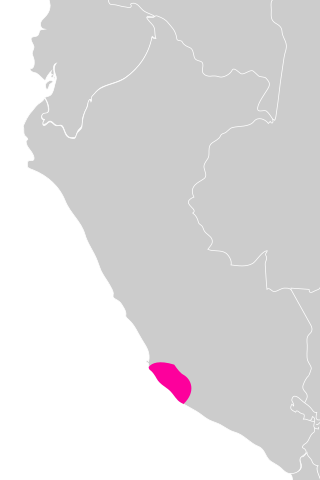
Caravelí Province is one of eight provinces in the Arequipa Region of Peru, with its capital in the city of Caravelí. It borders the Ayacucho department to the north; the provinces of La Unión, Condesuyos, and Camaná to the east; the Pacific Ocean to the south; and the Ica department to the west.

Inca cuisine originated in pre-Columbian times within the Inca civilization from the 13th to the 16th century. The Inca civilization stretched across many regions on the western coast of South America, and so there was a great diversity of unique plants and animals used for food. The most important plant staples involved various tubers, roots, and grains; and the most common sources of meat were guinea pigs, llamas, fish, and other aquatic and terrestrial organisms (305-307). Cuisine was heavily influenced by the Inca's food storage system, social gatherings and celebrations, and social status (308-315).

Raqch'i (Quechua) is an Inca archaeological site in Peru located in the Cusco Region, Canchis Province, San Pedro District, near the populated place Raqch'i. It is 3480 meters above sea level and 110 kilometers from the city of Cuzco. It also known as the Temple of Wiracocha, one of its constituents. Both lie along the Vilcanota River. The site has experienced a recent increase in tourism in recent years, with 83,334 visitors to the site in 2006, up from 8,183 in 2000 and 452 in 1996.

A qullqa (Quechua pronunciation:[ˈqʊʎˌqa] "deposit, storehouse"; was a storage building found along roads and near the cities and political centers of the Inca Empire. These were large stone buildings with roofs thatched with "ichu" grass, or what is known as Peruvian feathergrass. To a "prodigious [extent] unprecedented in the annals of world prehistory" the Incas stored food and other commodities which could be distributed to their armies, officials, conscripted laborers, and, in times of need, to the populace. The uncertainty of agriculture at the high altitudes which comprised most of the Inca Empire was among the factors which probably stimulated the construction of large numbers of qullqas.
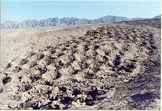
The Band of Holes, also known in Spanish as Monte Sierpe or Cerro Viruela, is a series of about 5,000–6,000 man-sized holes found in the Pisco Valley on the Nazca Plateau in Peru. Local people have no idea who made them or how they were used. Over the years, it has been speculated that they were graves, defensive positions, or storage places. Recent thought is that they were storage pits built during the time of the Inca Empire (1438–1533).

Huánuco Pampa, Huánuco Marka or Huánuco Viejo, Wanako Pampa, Wanuku Pampa or simply Huánuco is a large archaeological site in Peru in the Huánuco Region, Dos de Mayo Province, La Unión District. The ruins of the city lie on a plateau above the Urqumayu or Vizcarra River in the central Andes. The Incas administered their large empire through a small number of administrative centers, such as Huánuco Pampa. The administrative centers were linked by the extensive Inca road system. The most important of the roads, the Qhapaq Ñan, which ran from Cusco to Quito, passed through Huánuco Pampa. The Inca authorities in Huánuco ruled at least five, and perhaps more, ethnic groups. The city is situated on an important commercial trade route and sits on top of a plateau with ravines on all sides in order to allow easy defense of the city. During the Spanish conquest of the Incas, Huánuco Pampa was briefly occupied by Gomez de Alvarado, who founded a Spanish city but it was quickly moved to Pillco because of the harsh climate of Huánuco and the raids of Illa Tupac, one of the captains of Manco Inca.

Marayniyoq or Marayniyoc is an archaeological site in the region of Ayacucho in Peru. It lies southeast of the town of Huanta and southwest of Huamanguilla at the border of the Huanta Province, Huamanguilla District and the Huamanga Province, Pacaycasa District in a plain called Vega Pampa. It is considered a Wari site.
Tinyaq or Quri Willka is an archaeological site in Peru with storehouses of the Inca period on a mountain named Tinyaq. It is located in the Ayacucho Region, Huanta Province, Iguain District.
Inka Raqay hispanicized spelling Incaraqay) or Allqu Willka(Allcuhuillca, Alkowillka) is an archaeological site in the Ayacucho Region in Peru. It is located in the Huanta Province, Iguain District, on top of the mountain named Allqu Willka.
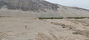 Plaza 1 in Tambo Viejo, in 2022
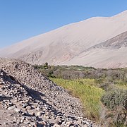 External walls, Tambo Viejo, in 2022
 Plaza 2 in Tambo Viejo, in 2022


