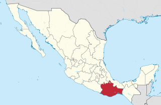
Oaxaca, officially the Free and Sovereign State of Oaxaca, is one of the 32 states that compose the Federative Entities of Mexico. It is divided into 570 municipalities, of which 418 are governed by the system of usos y costumbres with recognized local forms of self-governance. Its capital city is Oaxaca de Juárez.
Santa Catarina Juquila is a town in the State of Oaxaca, Mexico, and is the seat of the municipality also called Santa Catarina Juquila. It is part of the Juquila District in the center of the Costa Region. The name "Juquila" comes from "Xuhquililla", which means "Place of blue milkweed".
Acatlán de Pérez Figueroa is a town and municipality in Oaxaca in south-western Mexico. It is part of the Tuxtepec District of the Papaloapan Region. The name "Acatlán" means "among the reeds". Luis Pérez Figueroa was a general.
Guevea de Humboldt is a town and municipality in Oaxaca in south-western Mexico. It in the north of the Tehuantepec District, which is in the west of the Istmo Region.
Huautepec is a town and municipality in Oaxaca in south-western Mexico. The municipality covers an area of 35.72km². It is part of the Teotitlán District in the north of the Cañada Region. As of 2005, the municipality had a total population of 5,672.
Nejapa de Madero is a town and municipality in Oaxaca in south-western Mexico. It is part of the Yautepec District in the east of the Sierra Sur Region, not far from the main highway between Oaxaca, Oaxaca and Salina Cruz. The name "Nejapa" means "ash water".
San Juan Cotzocon is a town and municipality in Oaxaca in south-western Mexico. It is part of the Sierra Mixe district within the Sierra Norte de Oaxaca Region.
San Juan Guichicovi is a town and municipality in Oaxaca in south-western Mexico. It is part of the Juchitán District in the west of the Istmo de Tehuantepec region. The town was founded on 15 March 1825: Guichicovi means "New Town" in Zapotec.

San Juan Juquila Mixes is a town and municipality in Oaxaca in south-western Mexico. It is part of the Yautepec District in the east of the Sierra Sur Region. The name "Juquila" means "beautiful vegetables".
San Juan Mazatlán is a town and municipality in Oaxaca in south-western Mexico. It is part of the Sierra Mixe district within the Sierra Norte de Oaxaca Region. Mazatlán's name in Nahuatl means "the place of deer".
San Lucas Camotlán is a town and municipality in Oaxaca in south-western Mexico. The municipality covers an area of 127.58 km². It is part of the Sierra Mixe district within the Sierra Norte de Oaxaca Region.
San Miguel Panixtlahuaca is a town and municipality in Oaxaca in south-western Mexico. It is part of the Juquila District in the center of the Costa Region. The name "Panixtlahuatl" in the Nahuatl language means "Plain of the Bridge".
San Miguel Quetzaltepec is a town and municipality in Oaxaca in south-western Mexico. It is part of the Sierra Mixe district within the Sierra Norte de Oaxaca Region.
Santa María Alotepec is a town and municipality in Oaxaca in south-western Mexico. It is part of the Sierra Mixe district within the Sierra Norte de Oaxaca region.
Santa María Guienagati is a town and municipality in Oaxaca in south-western Mexico. It is in the north of the Tehuantepec District in the west of the Istmo Region. The town was first settled by Zapotec migrants from Zaachila, and the name Guienagati comes from Zapotec words meaning "Wilted Flower".
Santiago Atitlán is a town and municipality in Oaxaca in south-western Mexico. It is part of the Sierra Mixe district within the Sierra Norte de Oaxaca Region.
Santiago Camotlán is a town and municipality in Oaxaca in south-western Mexico. It is part of the Villa Alta District in the center of the Sierra Norte Region.
Santiago Ixcuintepec is a town and municipality in Oaxaca in south-western Mexico. It is part of the Sierra Mixe district within the Sierra Norte de Oaxaca Region.
Santiago Lachiguiri is a town and municipality in Oaxaca in south-western Mexico. It is part of the Tehuantepec District in the west of the Istmo Region.

The Indigenous people of Oaxaca are descendants of the inhabitants of what is now the state of Oaxaca, Mexico who were present before the Spanish invasion. Several cultures flourished in the ancient region of Oaxaca from as far back as 2000 BC, of whom the Zapotecs and Mixtecs were perhaps the most advanced, with complex social organization and sophisticated arts.


