Bordering communities
Places adjacent to Tankville | ||||||||||||||||
|---|---|---|---|---|---|---|---|---|---|---|---|---|---|---|---|---|
| ||||||||||||||||
Tankville is a neighbourhood in the city of Moncton. [1] Tankville was officially amalgamated with Moncton in 1973.
| Name | Category | Owner/Est Pop | Notes |
|---|---|---|---|
| Royal Oaks | Residential | ||
| Royal Oaks Golf Club | Golf Course | ||
| Pinetree Mini Homes | Residential | ||
| Tankville Museum | Culture | City of Moncton | |
| Moncton High School | Education | ||
| Moncton/McEwen Aerodrome | Airport | ||
Places adjacent to Tankville | ||||||||||||||||
|---|---|---|---|---|---|---|---|---|---|---|---|---|---|---|---|---|
| ||||||||||||||||
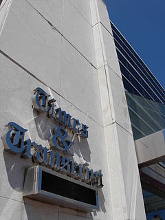
The Times & Transcript is a newspaper from Moncton, New Brunswick. It serves Greater Moncton and eastern New Brunswick. Its offices and printing facilities are located on Main Street in Downtown Moncton. The paper is published by Brunswick News.
CBAL-FM is a Canadian radio station, which broadcasts SRC's Ici Musique network at 98.3 FM in Moncton, New Brunswick.

The Gunningsville Bridge has been a name given to five different bridges that crossed the Petitcodiac River between Moncton at Route 106 and Riverview, New Brunswick at Route 114, New Brunswick, Canada. The latest Gunningsville Bridge opened on November 19, 2005. This is one of two links that cross the Petitcodiac River from Moncton to Riverview; the other is the Petitcodiac River Causeway. The Route links Vaughan Harvey Blvd In Moncton with Gunningsville Blvd In Riverview.
CKNI-FM is a Canadian radio station broadcasting at 91.9 FM in Moncton, New Brunswick. Owned by Acadia Broadcasting, the station broadcasts an adult contemporary format branded as 91.9 The Bend. CKNI's studios and offices are located at Jones Lake Place on Main Street in Moncton.

The Superior Propane Centre, is a multi-purpose arena in Moncton, New Brunswick which opened on November, 8 2003 with four NHL sized ice surfaces, one of which has seating for 1,500 spectators. It was home to the Moncton Beavers of the Maritime Junior A Hockey League until 2007 when they moved to Dieppe and became the Dieppe Commandos. It is the home of the Moncton Mariposa Figure Skating Club, the Moncton Minor Hockey Association the Moncton Ringette Association and Lacrosse Moncton. The facility also contains a pro shop, full-service restaurant, coffee shop and meeting facilities.

The Moncton SportsDome is a sporting facility in Moncton, New Brunswick, Canada, that offers a variety of activities such as paintball, soccer, Laser tag, golf range and Canadian Football. It is an air supported structure that measures 400 feet (120 m) long, 118 feet (36 m) wide, and 50 feet (15 m) high. It comprises two, 175-foot (53 m) long by 100-foot (30 m) wide synthetic fields with additional space outside the fields for walking and spectating.
Resurgo Place in Moncton, New Brunswick, Canada is the new home of the Moncton Museum, the Transportation Discovery Centre and also houses the main Moncton Visitor Information Centre. It is located at 20 Mountain Road in downtown Moncton. After an extensive consultation process with community stakeholders and school children, the new name, Resurgo Place and a new logo was unveiled in March 2013. The name Resurgo which means “I rise again” is Latin and is the first motto (1890) of the City of Moncton.
Kiwanis Park is a 3,500 seat baseball field located in Moncton, New Brunswick. The field was donated to the City of Moncton in 1953 by the local Kiwanis Club. It is the largest baseball field in Canada east of Quebec City. The field is the current home of the Moncton Fisher Cats and also, the Junior and Minor league Metro Mudcats. It has played host to many baseball tournaments including the 1975 Intercontinental Cup, the 1997 World Junior Baseball Championship, and the 2004 Baseball Canada Senior Championships.

CITA-FM is a Canadian radio station, broadcasting a Christian programming format at 105.1 FM in Moncton, New Brunswick.

Magnetic Hill is a Canadian neighbourhood in the north-west area of Moncton, New Brunswick. Magnetic Hill is located around the intersection of Route 126 and Route 2. Magnetic Hill is partially within the community of Lutes Mountain.
Ammon is a Canadian community in Moncton Parish, New Brunswick. Ammon includes the Intersection at Ammon Rd and New Brunswick Route 490. Ammon is in part of Greater Moncton.
Canadian Forces Base Moncton or CFB Moncton is a former Canadian Forces Base located in Moncton, New Brunswick.

Victoria Park is a rectangular well-manicured and mature urban green space in Downtown Moncton containing monuments, a bandstand, fountain and walking paths. It is bound by John Street to the north, Cameron Street to the west, Weldon Street to the east and Park Street to the south. It is also contains a cenotaph and is the site of the city's annual Remembrance Day ceremony. Various footpaths allows visitors to navigate the different features of the park. Victoria Park has served as the backdrop for significant community events, including royal visits, commemorative celebrations and annual craft fairs.
Lewisville is a Neighbourhood in the city of Moncton, New Brunswick.
Harrisville is a neighbourhood in Moncton, New Brunswick. It is notable for being in the vicinity of the Greater Moncton International Airport.
Humphrey is a neighbourhood in Moncton, New Brunswick.
Caledonia a neighbourhood of the city of Moncton. It is the furthest northeast neighbourhood in Greater Moncton.
Centennial is a neighbourhood in Moncton, New Brunswick.
Central Moncton is a neighbourhood in Moncton, New Brunswick. Its boundaries include Vaughan Harvey to the West, Connaught Ave and Wheeler Blvd to the North and Botsford Street to the East with John St and Mountain Road to the south.

RCAF Station Moncton or RCAF Aerodrome Moncton or BCATP Station Moncton, was a Second World War training air station of the British Commonwealth Air Training Plan (BCATP). It was located east of Moncton, New Brunswick, Canada.
Coordinates: 46°08′56″N64°47′31″W / 46.148919°N 64.792042°W