Tanners' Tower

Last updated

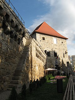
The Tanners' Tower (Romanian : Turnul Tăbăcarilor, German : Gerberturm) in Sighişoara, belonging to Mureș County, Romania, was built around the 13th14th centuries in the southeastern part of the city. It has a square plan, with a small, sloping roof in a single direction. This tower was supposed to guard and protect the courtyard of the Clock Tower.

Romanian language Romance language

Romanian is an Eastern Romance language spoken by approximately 24–26 million people as a native language, primarily in Romania and Moldova, and by another 4 million people as a second language. It is an official and national language of Romania and Moldova. In addition, it is also one of the official languages of the European Union.

German language West Germanic language

German is a West Germanic language that is mainly spoken in Central Europe. It is the most widely spoken and official or co-official language in Germany, Austria, Switzerland, South Tyrol (Italy), the German-speaking Community of Belgium, and Liechtenstein. It is also one of the three official languages of Luxembourg and a co-official language in the Opole Voivodeship in Poland. The languages which are most similar to German are the other members of the West Germanic language branch: Afrikaans, Dutch, English, the Frisian languages, Low German/Low Saxon, Luxembourgish, and Yiddish. There are also strong similarities in vocabulary with Danish, Norwegian and Swedish, although those belong to the North Germanic group. German is the second most widely spoken Germanic language, after English.

Sighișoara City in Mureș County, Romania

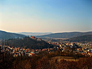
Sighișoara is a city on the Târnava Mare River in Mureș County, Romania. Located in the historic region of Transylvania, Sighișoara has a population of 28,102 according to the 2011 census. It is a popular tourist destination for its well-preserved walled old town, which is listed by UNESCO as a World Heritage Site.

Shape and position retracted behind the wall recommend it as one of the old towers, perhaps even the first one of the city. This tower with archaic aspect was not affected in any way by the fire in 1676. To defend the tower, tanneries used to have: a double arquebuse as well as a simple one, a musket, three hundred pounds of gunpowder and some cannonballs [1]

Arquebus Type of long gun that appeared in Europe during the 15th century

The arquebus, derived from the German Hakenbüchse, was a form of long gun that appeared in Europe during the 15th century. Although the term arquebus was applied to many different forms of firearms from the 15th to 17th centuries, it originally referred to "a hand-gun with a hook-like projection or lug on its under surface, useful for steadying it against battlements or other objects when firing." These "hook guns" were in their earliest forms defensive weapons mounted on German city walls in the early 1400s, but by the late 1400s had become handheld firearms. The development of the arquebus is somewhat tied to technology developed for the crossbow as without the stock from the crossbow, the arquebus would not have a stable platform to rest one's shoulder on. Priming pans also were placed on the arquebus. A matchlock mechanism was added around 1475 and it became the first firearm with a trigger. The heavy arquebus, known as the musket, was developed to better penetrate plate armor and appeared in Europe around 1521. A standardized arquebus, the caliver, was introduced in the latter half of the 16th century. The name "caliver" is derived from the English corruption of calibre, which is a reference to the gun's standardized bore. The caliver allowed troops to load bullets faster since they fit their guns more easily, whereas before soldiers often had to modify their bullets into suitable fits, or were even forced to make their own prior to battle. The smoothbore matchlock arquebus is considered the forerunner to the rifle and other long gun firearms. Heavy arquebuses mounted on wagons were called arquebus à croc. These carried a lead ball of about 3.5 ounces (100 g).

Musket firearm

A musket is a muzzle-loaded long gun that appeared as a smoothbore weapon in early 16th-century Europe, at first as a heavier variant of the arquebus, capable of penetrating heavy armor. By the mid-16th century, this type of musket went out of use as heavy armor declined, but as the matchlock became standard, the term musket continued as the name given for any long gun with a flintlock, and then its successors, all the way through the mid-1800s. This style of musket was retired in the 19th century when rifled muskets became common as a result of cartridged breech-loading firearms introduced by Casimir Lefaucheux in 1835, the invention of the Minié ball by Claude-Étienne Minié in 1849, and the first reliable repeating rifle produced by Volcanic Repeating Arms in 1854. By the time that repeating rifles became common, they were known as simply "rifles", ending the era of the musket.

Gunpowder explosive most commonly used as propellant in firearms

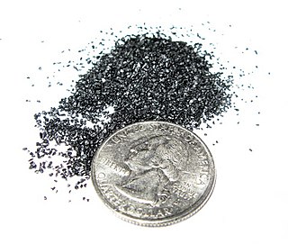
Gunpowder, also known as black powder to distinguish it from modern smokeless powder, is the earliest known chemical explosive. It consists of a mixture of sulfur (S), charcoal (C), and potassium nitrate (saltpeter, KNO3). The sulfur and charcoal act as fuels while the saltpeter is an oxidizer. Because of its incendiary properties and the amount of heat and gas volume that it generates, gunpowder has been widely used as a propellant in firearms, artillery, rockets, and fireworks, and as a blasting powder in quarrying, mining, and road building.

Coordinates: 46°13′07″N24°47′33″E / 46.21860°N 24.79256°E / 46.21860; 24.79256

Geographic coordinate system Coordinate system

A geographic coordinate system is a coordinate system that enables every location on Earth to be specified by a set of numbers, letters or symbols. The coordinates are often chosen such that one of the numbers represents a vertical position and two or three of the numbers represent a horizontal position; alternatively, a geographic position may be expressed in a combined three-dimensional Cartesian vector. A common choice of coordinates is latitude, longitude and elevation. To specify a location on a plane requires a map projection.

Related Research Articles

Cluj-Napoca City in Cluj County, Romania

Cluj-Napoca, commonly known as Cluj, is the fourth most populous city in Romania, and the seat of Cluj County in the northwestern part of the country. Geographically, it is roughly equidistant from Bucharest, Budapest and Belgrade. Located in the Someșul Mic River valley, the city is considered the unofficial capital to the historical province of Transylvania. From 1790 to 1848 and from 1861 to 1867, it was the official capital of the Grand Principality of Transylvania.

Iași County Seat in Romania

Iași is the second largest city in Romania, and the seat of Iași County. Located in the historical region of Moldavia, Iași has traditionally been one of the leading centres of Romanian social, cultural, academic and artistic life. The city was the capital of the Principality of Moldavia from 1564 to 1859, then of the United Principalities from 1859 to 1862, and the capital of Romania from 1916 to 1918.

Sibiu City in Romania

Sibiu is a city in Transylvania, Romania, with a population of 147,245. Located some 275 km (171 mi) north-west of Bucharest, the city straddles the Cibin River, a tributary of the river Olt. Now the capital of Sibiu County, between 1692 and 1791 and 1849–65 Sibiu was also the capital of the Principality of Transylvania.

Mediaș Municipality in Sibiu County, Romania

Mediaș is the second largest city in Sibiu County, Transylvania, Romania.

Târnăveni Municipality in Mureș County, Romania

Târnăveni is a city in Mureș County, central Romania. It lies on the Târnava Mică River in central Transylvania. The city administers three villages: Bobohalma (Bábahalma), Botorca (Őrhegy) and Cuștelnic (Csüdőtelke); the last was part of Gănești Commune until 2002.

Cetatea de Baltă Commune in Alba County, Romania

Cetatea de Baltă is a commune in Alba County, Romania. It is located between Târnăveni at 15 kilometers and Blaj at 21 kilometers on the county road DJ 117. The commune is composed of four villages: Cetatea de Baltă, Crăciunelu de Sus, Sântămărie and Tătârlaua.

Cluj-Napoca Tailors Bastion heritage site in Cluj County, Romania

The Cluj-Napoca Tailors' Tower is located at the southeast corner of the old Cluj-Napoca citadel. It was built in the 15th century and rebuilt between 1627 and 1629, assuming its present form. It was named after the Tailors' Guild, who took care of and guarded this part of the city. Near the tower — where Baba Novac, general of Michael the Brave and Saski priest, was killed in 1601 by General Basta — there is a statue of Baba Novac.

Transfiguration Cathedral, Cluj-Napoca cathedral

The Transfiguration Cathedral, also known as the Minorites' Church, was donated in 1924 by the Holy See to the Romanian Greek-Catholic Church to serve as the Cathedral of the Cluj-Gherla Eparchy, after the move of the Eparchy's center from Gherla to Cluj.

Jidvei Commune in Alba County, Romania

Jidvei is a commune in Alba county, Romania, located on the Târnava River. Jidvei is located in the north-western part of Romania, in the Transylvanian Plateau. Jidvei was first mentioned in documents in 1309, but traces of human presence go further back in time. The oldest building in the village is the church, which was originally constructed in the Gothic style but was later modified in 1707 in the baroque style. In the 15th century, a fortification wall was raised around the church, of which the gate tower remains.

Unirii Square, Cluj-Napoca square in Cluj-Napoca, Romania

Piața Unirii is the largest and most important squares in the Romanian city of Cluj-Napoca. The square is one of the largest in Romania, with dimensions of 220 m by 160 m. The central district of the city spreads out from this square. The St. Michael's Church, with the highest church tower in Romania (80m), is the second largest Gothic-style church in Romania. The church was constructed in two phases. The first from 1316 to 1390 and the second from 1410 to 1487. Also, the statue of King of Hungary Matthias Corvinus is located here.

Bazna Commune in Sibiu County, Romania

Bazna is a commune located in Sibiu County, Romania. It is composed of three villages: Bazna, Boian and Velț. It lies 13 km northeast of Mediaş, within the catchment area of the Târnava Mică River.

Cristian, Sibiu Commune in Sibiu County, Romania

Cristian is a commune located in Sibiu County, Romania. It is composed of a single village, Cristian, located on the Cibin. The village was founded in 1223 by German settlers.

Laslea Commune in Sibiu County, Romania

Laslea is a commune located in Sibiu County, Romania. It is composed of five villages: Florești, Laslea, Mălâncrav, Nou Săsesc and Roandola.

Iacobeni, Sibiu Commune in Sibiu County, Romania

Iacobeni is a commune located in Sibiu County, Romania.

Valea Viilor Commune in Sibiu County, Romania

Valea Viilor is a commune located in Sibiu County, Romania. It has a population of 2,034, and is composed of two villages, Motiș and Valea Viilor. Each of these has a fortified church, Motiș fortified church and Valea Viilor fortified church.

Judgement Tower

The Judgement Tower is a fortified medieval tower in the city of Maribor, Slovenia. An original tower built on the site in the early 14th century secured the southwestern corner of the city walls. It was completely rebuilt in 1540, with the addition of a conical roof which burned down in the 17th century.

Transylvanian Plain

The Transylvanian Plain is an ethnogeographical area in Transylvania, Romania, located between the Someş River and the Mureş River.

Cluj-Napoca City Hall city hall

Cluj-Napoca City Hall, located at 3 Moților Street, is the seat of government for Cluj-Napoca, Romania. Built at the end of the 19th century after the plans of architect Ignác Alpár, it features a Viennese baroque facade with a corner clock tower. Affixed to the tower was the seal of Kolozs County, of which the city was the seat when it was part of Austria-Hungary before 1918, as the building initially housed the county's headquarters. The building was erected according to the city's 1798 development plan, whereby every new building had to be approved by the city council. During its days as county headquarters, the building served multiple purposes–as a political, administrative and fiscal centre. At the same time, the large halls hosted exhibitions of both established and younger artists, and, starting at the turn of the 20th century, the city's balls.

Tinsmiths Tower

The Tinsmiths' Tower is one of the nine towers located in the citadel of Sighișoara, belonging to Mureș County in Romania.Tinsmith’s Tower has the most expressive architecture: 25 meters high, the tower starts with a square base, right after the brick trunk stands in pentagonal shape and above suddenly widens and becomes octagonal. The roof, slightly unbalanced, has a hexagonal plan and the woodwork inside is a veritable masterpiece of carpenters of Sighisoara. The Tin Tower, together with the Clock Tower, has an exceptional defensive position.

References

  1. Baltag, Gheorghe (2015). Istoria Sighisoarei de la intemeierea orasului pana la 1945. Sibiu: Honterus. p. 153.