Burkina Faso is a landlocked Sahel country that shares borders with six nations. It lies between the Sahara desert and the Gulf of Guinea, south of the loop of the Niger River, mostly between latitudes 9° and 15°N, and longitudes 6°W and 3°E. The land is green in the south, with forests and fruit trees, and semi-arid in the north. Most of central Burkina Faso lies on a savanna plateau, 198–305 metres (650–1,001 ft) above sea level, with fields, brush, and scattered trees. Burkina Faso's game preserves – the most important of which are Arly, Nazinga, and W National Park—contain lions, elephants, hippopotamus, monkeys, common warthogs, and antelopes. Previously the endangered painted hunting dog, Lycaon pictus occurred in Burkina Faso, but, although the last sightings were made in Arli National Park, the species is considered extirpated from Burkina Faso.

Ganzourgou is a province of Burkina Faso and is in Plateau-Central Region. The capital of Ganzourgou is Zorgho, which is along the road between Ouagadougou and Niamey, Niger. Other important localities in the province are Mogtédo and Méguet. The population of Ganzourgou in 2019 was 481,794.

The W National Park or W Regional Park is a major national park in West Africa around a meander in the Niger River shaped like the letter W. The park includes areas of the three countries Niger, Benin and Burkina Faso, and is governed by the three governments. Until 2008, the implementation of a regional management was supported by the EU-funded project ECOPAS. The three national parks operate under the name W Transborder Park. The section of W National Park lying in Benin, measuring over 8,000 km2 (3,100 sq mi), came under the full management of African Parks in June 2020. In Benin, W National Park is contiguous with Pendjari National Park which is also under the management of African Parks.

Tillabéri is one of the seven Regions of Niger; the capital of the Region is Tillabéri. Tillabéri Region was created in 1992, when Niamey Region was split, with Niamey and its immediate hinterland becoming a new capital district enclaved within Tillabéri Region.

Arli National Park, often called Arly, is a national park located in Tapoa Province, southeastern Burkina Faso. It adjoins Benin's Pendjari National Park in the south and the Singou Reserve in the west.

Tapoa is one of the 45 provinces of Burkina Faso. It is located in the Est Region. Its capital is Diapaga.

Diapaga is a city in, and the capital of, Tapoa Province, situated in eastern Burkina Faso. The main ethnic group in the city are the Gourmantché. It is a major centre for health services in the region. The W Park militant group of Burkina Faso are reported to have their headquarters in the town.

Arly-Singou is a 6,388 km2 (2,466 sq mi) large ecosystem in Burkina Faso. It encompasses the Arli National Park and the Singou Reserve. It is considered to comprise part of the most significant and important savanna woodland wildlife areas still existing in West Africa.

Diapaga is a department or commune of Tapoa Province in eastern Burkina Faso. Its capital is the town of Diapaga.

Kantchari is a department or commune of Tapoa Province in eastern Burkina Faso. Its capital is the town of Kantchari.

Logobou is a department or commune of Tapoa Province in eastern Burkina Faso. Its capital is the town of Logobou.

Namounou is a department or commune of Tapoa Province in eastern Burkina Faso. Its capital lies at the town of Namounou.

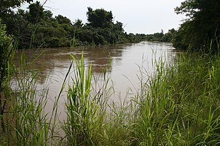
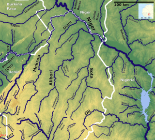
The Mékrou River is a river of Benin, Burkina Faso, and Niger. It flows through the W National Park.

The Sirba River is a tributary of the Niger River in western Africa. The Sirba arises in Burkina Faso and flows east, crosses into Niger and then forms a short part of the international border between the two countries. It meets the Niger River at the midway point between the settlements of Gothèye and Karma in Niger, about 50 kilometres upstream from Niamey.

The Burkina Faso-Niger frontier dispute case (2013) was a public international law case with the International Court of Justice served by the West African states of Burkina Faso and Niger, which share a border. Both nations submitted a border dispute to the court in 2010. The court delivered its judgement in 2013, and the parties implemented it in 2015 and 2016.

Botou is a department or commune of Tapoa Province in eastern Burkina Faso. Its capital is the town of Botou. The department constitutes a panhandle that stretches into Niger.

W-Arly-Pendjari Complex, also known as the "WAP Complex", is a transboundary Natural UNESCO World Heritage Site in Benin, Burkina Faso and Niger covering:

The Burkina Faso–Niger border is 622 km in length and runs from the tripoint with Mali in the north to the tripoint with Benin in the south.

The Benin–Burkina Faso border is 386 km in length and runs from the tripoint with Togo in the southwest to the tripoint with Niger in the northeast.
This page is based on this
Wikipedia article Text is available under the
CC BY-SA 4.0 license; additional terms may apply.
Images, videos and audio are available under their respective licenses.


