
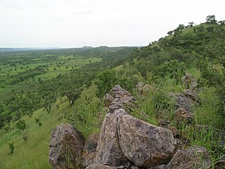
Burkina Faso is a landlocked Sahel country that shares borders with six nations. It lies between the Sahara desert and the Gulf of Guinea, south of the loop of the Niger River, mostly between latitudes 9° and 15°N, and longitudes 6°W and 3°E. The land is green in the south, with forests and fruit trees, and semi-arid in the north. Most of central Burkina Faso lies on a savanna plateau, 198–305 metres (650–1,001 ft) above sea level, with fields, brush, and scattered trees. Burkina Faso's game preserves – the most important of which are Arly, Nazinga, and W National Park—contain lions, elephants, hippopotamus, monkeys, common warthogs, and antelopes. Previously the endangered painted hunting dog, Lycaon pictus occurred in Burkina Faso, but, although the last sightings were made in Arli National Park, the species is considered extirpated from Burkina Faso.

Ghana is a West African country in Africa, along the Gulf of Guinea.

Transport in Ghana is accomplished by road, rail, air and water. Ghana's transportation and communications networks are centered in the southern regions, especially the areas in which gold, cocoa, and timber are produced. The northern and central areas are connected through a major road system.

Togo is a small Sub-Saharan state, comprising a long strip of land in West Africa. Togo's geographic coordinates are a latitude of 8° north and a longitude of 1°10′ east. It is bordered by three countries: Benin to the east, with 644 km (400 mi) of border; Burkina Faso to the north, with 126 km (78 mi) of border; and Ghana, with 877 km (545 mi) of border. To the south Togo has 56 km (35 mi) of coastline along the Bight of Benin of the Gulf of Guinea in the North Atlantic Ocean. Togo stretches 579 km (360 mi) north from the Gulf and is only 160 km (99 mi) wide at the broadest point. In total, Togo has an area of 56,785 km2 (21,925 sq mi), of which 54,385 km2 (20,998 sq mi) is land and 2,400 km2 (927 sq mi) is water.

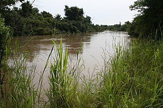
The Volta River is the main river system in the West African country of Ghana. It flows south into Ghana from the Bobo-Dioulasso highlands of Burkina Faso. The main parts of the river are the Black Volta, the White Volta, and the Red Volta. In the northwest, the Black Volta forms the international borders between the Ivory Coast, Ghana, and Burkina Faso. The Volta flows southward along the Akwapim-Togoland highlands, and empties into the Atlantic Ocean at the Gulf of Guinea at Ada Foah. One of its smaller tributaries, the Oti River, enters Ghana from Togo in the east. The Volta River has been dammed at Akosombo for generating hydroelectricity. The reservoir named Lake Volta stretches from Akosombo Dam in the south to the northern part of the country, and is the largest man-made reservoir by area in the world.

Benin, a narrow, key-shaped, north–south strip of land in West Africa, lies between the Equator and the Tropic of Cancer. Its latitude ranges from 6°30′ N to 12°30′ N and its longitude from 1° E to 3°40′ E. It is bounded by Togo to the west, Burkina Faso and Niger to the north, Nigeria to the east, and the Bight of Benin to the south.

The Black Volta or Mouhoun is a river that flows through Burkina Faso for approximately 1,352 km (840 mi) to the White Volta in Dagbon, Ghana, the upper end of Lake Volta. The source of the Black Volta is in the Cascades Region of Burkina Faso, close to Mount Tenakourou, the highest point of the country. Further downstream it forms part of the border between Ghana and Burkina Faso, and later between Côte d'Ivoire and Ghana. Within Ghana, it marks the border between the Savannah and Bono regions. The Bui Dam, a hydroelectric power plant, is built on the river, just south of the Bui National Park, which the river bisects.

The White Volta or Nakambé is the headstream of the Volta River, Ghana's main waterway. The White Volta emerges in northern Burkina Faso, flows through Northern Ghana and empties into Lake Volta in Ghana. The White Volta's main tributaries are the Black Volta and the Red Volta.

The Red Volta or Nazinon is a waterway located in West Africa. It emerges near Ouagadougou in Burkina Faso and has a length of about 320 km at the end of which it joins the White Volta in Ghana.

The Mono River is the major river of eastern Togo.
The Togo Mountains is a mountain range which stretches across the central region of the West African country of Togo and across the eastern and western borders of that country into Ghana and Benin. In Ghana, the range is also known as the Akwapim Hills, and in Benin it is also known as the Atakora Mountains. Part of the range is associated with the country of Niger, where the W National Park is found. The African wild dog, Lycaon pictus, was historically found in this region but may now be extirpated from this locale.

Burkina Faso is largely wild bush country with a mixture of grass and small trees in varying proportions. The savanna region is mainly grassland in the rainy season and semi desert during the harmattan period. Fauna, one of the most diverse in West Africa, includes the elephant, hippopotamus, buffalo, monkey, lions, crocodile, giraffe, various types of antelope, and a vast variety of bird and insect life. The country has 147 mammal species, 330 aquatic species including 121 species of fish and 2067 different plant species. Of the plant species, the dominant endemic species are shea tree and the baobab, the former plant species has immense economic value to the country.
Benin has varied resources of wildlife comprising flora and fauna, which are primarily protected in its two contiguous protected areas of the Pendjari National Park and W National Park. The former is known for many species of avifauna and the latter park is rich in mammals and predators. In addition, many other forest reserves are noted in the country but are not easily accessible, well protected or adequately surveyed for its wildlife resources. The protected area of Benin which is defined as a National Protected Area System is in northern Benin, mostly with a woody savanna ecosystem. It covers 10.3% of the nation and is part of the three-nation W-Arly-Pendjari Complex (WAP).

The wildlife of Togo is composed of the flora and fauna of Togo, a country in West Africa. Despite its small size the country has a diversity of habitats; there are only remnants of the once more extensive rain forests in the south, there is Sudanian savanna in the north-western part of the country and larger areas of Guinean forest–savanna mosaic in the centre and north-east. The climate is tropical with distinct wet and dry seasons. There are estimated to be over 3000 species of vascular plants in the country, and 196 species of mammals and 676 species of birds have been recorded there.

The following outline is provided as an overview of and topical guide to Burkina Faso:
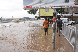
The 2009 West Africa floods are a natural disaster that began in June 2009 as a consequence of exceptionally heavy seasonal rainfall in large areas of West Africa. Several rivers, including the Pendjari, Niger, Volta and Senegal rivers, broke their banks, causing destruction of houses, bridges, roads and crops. The floods are reported to have affected 940,000 people across 12 countries, including Burkina Faso, Benin, Ghana, Niger, Senegal, Guinea, and caused the deaths of at least 193 people. In Burkina Faso, one of the most affected countries, 150,000 people fled their homes, mostly in the capital Ouagadougou where rainfall in one day was equal to 25% of normal annual rainfall for the whole country.

The Benin–Burkina Faso border is 386 km in length and runs from the tripoint with Togo in the southwest to the tripoint with Niger in the northeast.

The Burkina Faso–Togo border is 131 km in length and runs from the tripoint with Ghana in the west to the tripoint with Benin in the east.

