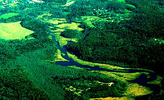
A swamp is a wetland that is forested. Many swamps occur along large rivers where they are critically dependent upon natural water level fluctuations. Other swamps occur on the shores of large lakes. Some swamps have hammocks, or dry-land protrusions, covered by aquatic vegetation, or vegetation that tolerates periodic inundation or soil saturation. The two main types of swamp are "true" or swamp forests and "transitional" or shrub swamps. In the boreal regions of Canada, the word swamp is colloquially used for what is more correctly termed a bog, fen, or muskeg. The water of a swamp may be fresh water, brackish water or seawater. Some of the world's largest swamps are found along major rivers such as the Amazon, the Mississippi, and the Congo.

The Pearl River is a river in the U.S. states of Mississippi and Louisiana. It forms in Neshoba County, Mississippi from the confluence of Nanih Waiya and Tallahaga creeks. and has a meander length of 444 miles (715 km). The lower part of the river forms part of the boundary between Mississippi and Louisiana. The river contains large areas of bottomland hardwood swamp and cypress swamp, providing habitat for many species of wildlife including sturgeon and black bears. As recently as 2008, endangered Ivory-billed woodpeckers were reportedly sighted here. The mouth of the river provides important marsh habitat along salinity gradients; these marshes have been the subject of many scientific studies. It is considered to be one of the most critical areas of natural habitat remaining in Louisiana. The Mississippi state capital, Jackson, is located on the river.

The littoral zone or nearshore is the part of a sea, lake or river which is close to the shore. In coastal environments the littoral zone extends from the high water mark, which is rarely inundated, to shoreline areas that are permanently submerged. It always includes this intertidal zone and is often used to mean the same as the intertidal zone. However, the meaning of "littoral zone" can extend well beyond the intertidal zone.

The Atchafalaya River is a 137-mile-long (220 km) distributary of the Mississippi River and Red River in south central Louisiana in the United States. It flows south, just west of the Mississippi River, and is the fifth largest river in North America, by discharge. The name "Atchafalaya" comes from Choctaw for "long river", from hachcha, "river", and falaya, "long".

The Apalachicola River is a river, approximately 112 mi (180 km) long in the State of Florida. The river's large watershed, known as the ACF River Basin, drains an area of approximately 19,500 square miles (50,505 km2) into the Gulf of Mexico. The distance to its farthest head waters in northeast Georgia is approximately 500 miles (800 km). Its name comes from the Apalachicola people, who used to live along the river.

The Siuslaw River is a river, about 110 miles (180 km) long, that flows to the Pacific Ocean coast of Oregon in the United States. It drains an area of about 773 square miles (2,000 km2) in the Central Oregon Coast Range southwest of the Willamette Valley and north of the watershed of the Umpqua River.

The Oti River or Pendjari River is an international river in West-Central Africa. It rises in Benin, forms the border between Benin and Burkino Faso, flows through Togo, and joins the Volta River in Ghana.

A tidal marsh is a marsh found along rivers, coasts and estuaries which floods and drains by the tidal movement of the adjacent estuary, sea or ocean. Tidal marshes experience many overlapping persistent cycles, including diurnal and semi-diurnal tides, day-night temperature fluctuations, spring-neap tides, seasonal vegetation growth and decay, upland runoff, decadal climate variations, and centennial to millennial trends in sea level and climate. They are also impacted by transient disturbances such as hurricanes, floods, storms, and upland fires.

The Hughes River is a tributary of the Little Kanawha River in western West Virginia in the United States. Via the Little Kanawha and Ohio Rivers, it is part of the watershed of the Mississippi River. As measured from the confluence of its north and south forks, the Hughes is 18 mi (29 km) long, and drains a rural area of the unglaciated portion of the Allegheny Plateau.

The Blackwater River is a 34.3-mile-long (55.2 km) river in the Allegheny Mountains of eastern West Virginia, USA. Via the Black Fork, it is a principal tributary of the Cheat River. Via the Cheat, the Monongahela and the Ohio rivers, it is part of the watershed of the Mississippi River and drains an area of 142 square miles (370 km2). It is a true blackwater stream, owing to spruce and hemlock trees in its watershed, the tannins of which impart a tea or amber color to its water.

The Rainwater Basin wetland region is a 4,200 sq mi (11,000 km2) loess plain located south of the Platte River in south-central Nebraska. It lies principally in Adams, Butler, Clay, Fillmore, Hamilton, Kearney, Phelps, Polk, Saline, Seward, and York counties and extends into adjacent areas of southeastern Hall, northern Franklin, northern Nuckolls, western Saline, northern Thayer and northwestern Webster counties. Before European settlement, this plain was covered by prairie grasslands interspersed with thousands of ephemeral playa wetlands, called Rainwater Basins. Informally and locally, individual Nebraska Rainwater Basins are referred to as rainbasins, basins, lagoons, lakes, ponds, marshes, hay marshes, and lakes marshes. To the west, a tallgrass prairie in the east once gradually transitioned into mixed grass prairie. Currently, the Rainwater Basin wetland region is covered by farms, mainly growing corn and soybeans. Several, interspersed, stream courses, of which largest is the Big Blue River and its tributaries, drain this region. Riparian woodlands and upland slopes possessing oak woodlands are associated with these streams. In the spring and fall months, millions of migratory birds pass through the region to feed and rest. Along with riparian habitats associated Platte River, Big Blue River,its tributaries, and smaller streams, Rainwater Basins are a major component of the Central Flyway of North America.

The geology of Minnesota comprises the rock, minerals, and soils of the U.S. state of Minnesota, including their formation, development, distribution, and condition.
The East Brookfield River is a 2.4-mile-long (3.9 km) river in Massachusetts that heads at Lake Lashaway in East Brookfield at an elevation of 614 feet (187 m) above sea level. It continues to Quaboag Pond, at an elevation of 594 feet (181 m).
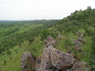
The Togo Mountains is a mountain range which stretches across the central region of the West African country of Togo and across the eastern and western borders of that country into Ghana and Benin. In Ghana, the range is also known as the Akwapim Hills, and in Benin it is also known as the Atakora Mountains. Part of the range is associated with the country of Niger, where the W National Park is found. The African wild dog, Lycaon pictus, was historically found in this region but may now be extirpated from this locale.
Jackson Bottom Wetlands Preserve in Hillsboro, Oregon, United States, is a 635-acre (257 ha) wetlands area along the Tualatin River in Washington County, Oregon. Located on the south end of the city along Highway 219, this lowland area is a designated Important Bird Area and hosts such birds as buffleheads, dusky Canada geese, and tundra swans.

The Katonga River is a river in Uganda, in East Africa.

A pond is a body of standing water, either natural or artificial, that is usually smaller than a lake. They may arise naturally in floodplains as part of a river system, or they may be somewhat isolated depressions. They may contain shallow water with marsh and aquatic plants and animals. The type of life in a pond is generally determined by a combination of factors including water level regime and nutrient levels, but other factors may also be important, including the presence or absence of shading by trees, presence or absence of streams, effects of grazing animals, and salinity.
The Crooked River is a 26.8-mile-long (43.1 km) river in Camden County in the U.S. state of Georgia. Primarily tidal, it is an inlet of Cumberland Sound.

The Nyabarongo is a major river in Rwanda, part of the upper headwaters of the Nile. At 297 km, it is the longest river entirely in Rwanda. The river begins its course at the confluence of the rivers Mbirurume and Mwogo in the South West of the country. These two rivers themselves begin in Nyungwe Forest, and are considered by some to be the most distant source of the Nile. From its start, Nyabarongo flows northward for 85 km, and forms the border between the Western and Southern Provinces. At the confluence with the river Mukungwa, the river changes course and flows eastward for 12 km, then to a more South Eastern course for the last 200 km. For the longest stretch of this course, the river serves as the boundary between the Northern and Southern Provinces, then between the City of Kigali and the Southern Province, and lastly between the City of Kigali and the Eastern Province. The river then before enters the Eastern Province and ends its course close to the border with Burundi. The Nyabarongo River empties both in Lake Rweru and Akagera river in a small but complicated Delta. The Akagera river outflows from Lake Rweru, a mere 1 km from the Nyabarongo delta. Almost all the branches of the Nyabarongo delta empty in the lake, however, one branch of the delta empties directly in the just formed Akagera river. The Akagera River eventually flows into Lake Victoria and forms the Nile.

The Southern Ewaso Ng'iro is a river in the Great Rift Valley in Kenya. It plays an important role in the ecology of Lake Natron, the main regular breeding site for near-threatened lesser flamingos. Changes to land use in the river's headwaters or in the marshes before the river enters the lake could have a serious impact on this species.