
Ghana is a West African country in Africa, along the Gulf of Guinea.
Adansi is a subgroup of the Akan ethnicity inhabiting the Ashanti Region of Ghana. An Adansihene is still designated. The Adansi has seven paramountcies: the capital, Fomena, New Edubiase, Ayaase, Akrokyere (Akrokerri), Akrofuom, Bodwesango and, Dompoase.

The Kwahu Plateau is a 260 km (160 mi) long plateau in southern Ghana. It consists of the uplifted southern edge of the Volta River Basin. It forms the main watershed of Ghana, separating rivers in the Volta River system from rivers in the western half of Ghana which flows into the Atlantic Ocean. The plateau has an average elevation of 1,500 feet and its highest point is Mount Akmawa at 2,586 feet. The plateau is dissected by several valleys and is marked by towering peaks. To the south it borders dense forest country, which it shields from the harmattan winds of the interior. Cacao cultivation has been introduced in the west, through which traditional trade routes lead to the Atlantic; vegetable cultivation is stressed in the eastern sector. The largest and most important towns on the Kwahu Plateau are Wenchi, Mampong, Mpraeso, and Abetifi.

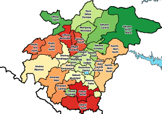
The Eastern Region is located in the Eastern part of Ghana and is one of the sixteen administrative regions of Ghana. Eastern region is bordered to the east by the Lake Volta, to the north by Bono East Region and Ashanti region, to the west by Ashanti region, to the south by Central region and Greater Accra Region. Akans are the dominant inhabitants and natives of Eastern region and Akan, Ewe, Krobo, Hausa and English are the main spoken languages. The capital town of Eastern Region is Koforidua.The Eastern region is the location of the Akosombo dam and the economy of the Eastern region is dominated by its high-capacity electricity generation. Eastern region covers an area of 19,323 square kilometres, which is about 8.1% of Ghana's total landform.

The Pra River is a river in Ghana, the easternmost and the largest of the three principal rivers that drain the area south of the Volta divide. Rising in the Kwahu Plateau near Mpraeso and flowing southward for 240 km through rich cocoa and farming areas and valuable forests in the Akan lowlands, the Pra enters the Gulf of Guinea east of Takoradi. In the 19th century, the Pra served as the border between the Ashanti Confederacy and the Gold Coast.
Asante Akim South Municipal District is one of the forty-three districts in Ashanti Region, Ghana. Originally created as an ordinary district assembly in 1988 as Asante Akim South District, which it was created from the former Asante Akim District Council. Later it was elevated to municipal district assembly status on 15 March 2018. The municipality is located in the eastern part of Ashanti Region and has Juaso as its capital town.
The Ofin River is an easterly-flowing waterway in Ghana. It flows through the Tano Ofin Reserve in Ghana's Atwima Mponua District.

Kara is a city in northern Togo, situated in Kara Region, 413 km north of the capital Lomé. Kara is the capital of the Kara region and, according to the 2010 census, had a population of 94,878. The Kara River flows through the city and is its main resource of water. The city developed from the 1970s onwards from the village originally known as Lama-Kara. Its growth was largely due to the influence of the previous Togolese head of state Gnassingbé Eyadéma; he was born in the nearby village of Pya and understood Kara's strategic position at a crossroads of two trade routes.

The Brule River is a 52.3-mile-long (84.2 km) river in the U.S. states of Michigan and Wisconsin. Nearly, almost all of the course forms a portion of the boundary between the two states.
Trout Creek is a 6.5-mile-long (10.5 km) tributary of Paint Creek in Oakland County, Michigan, in the United States. Via Paint Creek and the Clinton River, it is a tributary of Lake St. Clair.

Twifo/Heman/Lower Denkyira District is a former district that was located in Central Region, Ghana. Originally created as an ordinary district assembly in 1988, which was created from the former Denkyira District Council. However on 28 June 2012, it was split off into two new districts: Twifo-Atti Morkwa District and Hemang-Lower Denkyira District. The district assembly was located in the northwest part of Central Region and had Twifo Praso as its capital town.
Fuaigh Beag or Vuia Be(a)g is an island in the Outer Hebrides. It is off the west coast of Lewis near Great Bernera in Loch Roag. Its name means "little Fuaigh", and is named in contrast to Fuaigh Mòr nearby.
The Birim River is one of the main tributaries of the Pra River in Ghana and the country's most important diamond-producing area, flowing through most of the width of the Eastern region. The river rises in the east of the Atewa Range, flows north through the gap between this range and the Kwahu Plateau, then runs roughly south-west until it joins the Pra. It gives its name to the Birimian rock formation, which yields most of the gold in the region. Ghana is the second largest producer of gold in Africa.
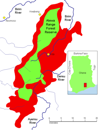
The Atewa Range Forest Reserve is in the Akyem Abuakwa region of southeastern Ghana, near the town of Kibi, and south-west of the Kwahu Plateau which forms the south-west boundary of Lake Volta. The range runs roughly north–south, consisting of steep-sided hills with fairly flat summits. It is the last remains of the Cenozoic peneplain that once covered southern Ghana, and contains ancient bauxitic soils. The range is the site of an important forest reserve, and the source of three major rivers.
Akumadan is the capital of Offinso North, a district in the Ashanti Region of Ghana. It has a population of about 20000. Akumadan township is well known for its agricultural activities. All sorts of food crops can be planted on its soil but tomatoes is the largest crop. 90 percent of natives above 18 years are tomato farmers. They produce more tomatoes than any other town in Ghana. It has a dam that helps to irrigate some farmlands within its reach during dry seasons. Cassava, pepper, onion, garden eggs, plantain, maize etc. are also abundant. A company called Fomghana has acquired a large area of land for planting trees near a river that irrigates it. Recently, the President Nana Addo Dankwa Akuffo-Addo formally opened a Greenhouse project. Its poised to train young people in Agric Technology.
Stella is an unincorporated community in Cowlitz County, Washington. Stella is located northwest of the city of Longview, reached by traveling westbound out of the city along Washington State Route 4, also known as Ocean Beach Highway, and turning north onto Stella Road. The Stella community is part of the Longview School District, a K-12 school district of about 6,600 students.

The Pra River is a river of Ghana. The Pra River rises in the Ashanti, roughly 33 miles (53 km) west of Mampong in the centre of the country, and runs to the northeast, with a length of 120 miles (190 km). Part of the area between the Pra and Anum rivers forms the Pra Anum Forest Reserve.

Kubang Pasu, officially known as the Kingdom of Kubang Pasu Darul Qiyam was a former Malay Kingdom located in the northern Malay Peninsula. The state was established in 1839 as a gift to Tunku Anum, a member of Kedahan nobility, for his efforts in ending the conflict between Kedah and Siam in the aftermath of the Siamese invasion in 1821. The kingdom witnessed the reign of two monarchs before it was re-integrated with Kedah in 1859.

Ayensuano District is one of the thirty-three districts in Eastern Region, Ghana. Originally it was formerly part of the then-larger Suhum-Kraboa-Coaltar District in 1988, which was created from the former Suhum-Kraboa-Coaltar District Council, until the southern part of the district was split off to create Ayensuano (district) on 28 June 2012; thus the remaining part has been renamed as Suhum Municipal District, which it was also elevated into municipal district assembly status on that same year. The district assembly is located in the southern part of Eastern Region and has Coaltar as its capital town.
