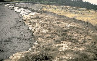
A lahar is a violent type of mudflow or debris flow composed of a slurry of pyroclastic material, rocky debris and water. The material flows down from a volcano, typically along a river valley.

Gaoua is a market town in southern Burkina Faso known for its superstitious values and customs. The population, at last estimate, rested at 30,931 Located in the red earth, green hills, and fast flowing streams of southwestern Burkina Faso, Gaoua is the capital of Poni Province and forms a sort of capital for the sacred rites and bush lore of the Lobi peoples. According to local myth, Gaoua was founded when the Lobi migrated across from northern Ghana where they found the Gan people peoples occupying the territory. As a result, they named the trek across to Gaoua Gan-houo meaning "route of the Gan people".

Carbonatite is a type of intrusive or extrusive igneous rock defined by mineralogic composition consisting of greater than 50% carbonate minerals. Carbonatites may be confused with marble and may require geochemical verification.

Tarkwa is a town and is the capital of Tarkwa-Nsuaem Municipal district, a district in the Western Region southwest of South Ghana. Tarkwa has a 2013 settlement population of 34,941 people.

Ralph Jackson Roberts (1911–2007) was an American geologist and research scientist with the USGS. He is credited with the discovery of the Carlin and Battle Mountain Gold Belts, which make up the richest gold-mining region in Nevada as well as the United States.
The Mining industry of Ghana accounts for 5% of the country's GDP and minerals make up 37% of total exports, of which gold contributes over 90% of the total mineral exports. Thus, the main focus of Ghana's mining and minerals development industry remains focused on gold. Ghana is Africa's largest gold producer, producing 80.5 t in 2008. Ghana is also a major producer of bauxite, manganese and diamonds. Ghana has 23 large-scale mining companies producing gold, diamonds, bauxite and manganese, and, there are also over 300 registered small scale mining groups and 90 mine support service companies.

Although the subsoil of Ivory Coast contained many other minerals, none existed in commercially exploitable amounts, given the high costs of extraction. Mining contributed only 1 percent of GDP in 1986.
Mining in Afghanistan is controlled by the Ministry of Mines and Petroleum, which is headquartered in Kabul with regional offices in other parts of the country. Afghanistan has over 1,400 mineral fields, containing barite, chromite, coal, copper, gold, iron ore, lead, natural gas, petroleum, precious and semi-precious stones, salt, sulfur, talc, and zinc, among many other minerals. Gemstones include high-quality emerald, lapis lazuli, red garnet and ruby. According to a joint study by The Pentagon and the United States Geological Survey, Afghanistan has an estimated US$3 trillion of untapped minerals.

Tajikistan has rich deposits of gold, silver, and antimony. The largest silver deposits are in Sughd Province, where Tajikistan's largest gold mining operation also is located. Russia's Norilsk nickel company has explored a large new silver deposit at Bolshoy Kanimansur. More than 400 mineral deposits of some 70 different minerals have been discovered in Tajikistan, including strontium, tungsten, molybdenum, bismuth, salt, lead, zinc, fluorspar, and mercury. These minerals have been found suitable for mining. Uranium, an important mineral in the Soviet era, remains in some quantity but is no longer extracted. The Tajikistan Aluminium Company (TALCO), an aluminium smelter, is the country's only large-scale production enterprise in the mining sector. Tajikistan hosts the annual Mining World Tajikistan, an international exhibition on mining in Dushanbe.

Kibi or Kyebi is a town and the capital of the East Akim Municipal District, a district in the Eastern Region of south Ghana, on the eastern slopes of the Atewa Range. Kibi lies at an altitude of 318 m, and, Kibi has a 2013 settlement population of 11,677 people.
The South Pass greenstone belt is located within the Wyoming craton in the US. The region was the site of Wyoming's initial gold discovery in 1842.
The West African Craton (WAC) is one of the five cratons of the Precambrian basement rock of Africa that make up the African Plate, the others being the Kalahari craton, Congo craton, Saharan Metacraton and Tanzania Craton. Cratons themselves are tectonically inactive, but can occur near active margins, with the WAC extending across 14 countries in Western African, coming together in the late Precambrian and early Palaeozoic eras to form the African continent. It consists of two Archean centers juxtaposed against multiple Paleoproterozoic domains made of greenstone belts, sedimentary basins, regional granitoid-tonalite-trondhjemite-granodiorite (TTG) plutons, and large shear zones. The craton is overlain by Neoproterozoic and younger sedimentary basins. The boundaries of the WAC are predominantly defined by a combination of geophysics and surface geology, with additional constraints by the geochemistry of the region. At one time, volcanic action around the rim of the craton may have contributed to a major global warming event.

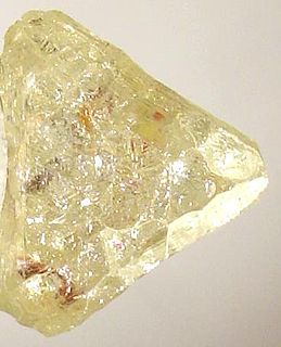
The Birimian rocks are major sources of gold and diamonds that extend through Ghana, Côte d'Ivoire, Guinea, Mali and Burkina Faso. They are named after the Birim River, one of the main tributaries of the Pra River in Ghana and the country's most important diamond-producing area. Ghana and Mali are the second and third largest producers of gold in Africa, respectively.
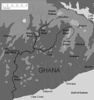
The Birim River is one of the main tributaries of the Pra River in Ghana and the country's most important diamond-producing area, flowing through most of the width of the Eastern region. The river rises in the east of the Atewa Range, flows north through the gap between this range and the Kwahu Plateau, then runs roughly south-west until it joins the Pra. It gives its name to the Birimian rock formation, which yields most of the gold in the region. Ghana is the second largest producer of gold in Africa.

The Iduapriem Gold Mine is an open-pit gold mine situated 10 km south of Tarkwa, in the Western Region of Ghana. The mine is owned by AngloGold Ashanti and consists of the Iduapriem and the Teberebie operation, which were merged in 2000. AngloGold Ashanti originally only owned 85% of the mine but acquired the remaining 15% in September 2007.
The Eburnean orogeny, or Eburnean cycle was a series of tectonic, metamorphic and plutonic events in what is now West Africa during the Paleoproterozoic era about 2200–2000 million years ago. During this period the Birimian domain in West Africa was established and structured.

The Juneau gold belt is located in the southeastern portion of the U.S. state of Alaska. This belt is approximately 100 miles (160 km) in length, north/northwest-trending, and extends from Berners Bay southeastward to Windham Bay, 60 miles (97 km) southeast of Juneau, and includes Douglas Island. The belt contains over 200 gold-quartz-vein deposits with production nearing 7,000,000 ounces (200,000,000 g) of gold. More than three-quarters of Alaska's lode gold was mined from the Juneau gold belt.

Koh-i-Sultan is a volcano in Balochistan, Pakistan. It is part of the tectonic belt formed by the collision of India and Asia: specifically, a segment influenced by the subduction of the Arabian plate beneath the Asian plate and forming a volcanic arc which includes the Bazman and Taftan volcanoes in Iran. The volcano consists of three main cones, with heavily eroded craters running west-northwest and surrounded by a number of subsidiary volcanic centres. Its summit is 2,334 metres (7,657 ft) high, and the crater associated with the Miri cone has a smaller crater inside.

The geology of Ghana is primarily very ancient crystalline basement rock, volcanic belts and sedimentary basins, affected by periods of igneous activity and two major orogeny mountain building events. Aside from modern sediments and some rocks formed within the past 541 million years of the Phanerozoic Eon, along the coast, many of the rocks in Ghana formed close to one billion years ago or older leading to five different types of gold deposit formation, which gave the region its former name Gold Coast.

The geology of Ivory Coast is almost entirely extremely ancient metamorphic and igneous crystalline basement rock between 2.1 and more than 3.5 billion years old, comprising part of the stable continental crust of the West African Craton. Near the surface, these ancient rocks have weathered into sediments and soils 20 to 45 meters thick on average, which holds much of Ivory Coast's groundwater. More recent sedimentary rocks are found along the coast. The country has extensive mineral resources such as gold, diamonds, nickel and bauxite as well as offshore oil and gas.

