
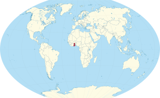
Ghana is a West African country in Africa, along the Gulf of Guinea.

The Sacramento River is the principal river of Northern California in the United States and is the largest river in California. Rising in the Klamath Mountains, the river flows south for 400 miles (640 km) before reaching the Sacramento–San Joaquin River Delta and San Francisco Bay. The river drains about 26,500 square miles (69,000 km2) in 19 California counties, mostly within the fertile agricultural region bounded by the Coast Ranges and Sierra Nevada known as the Sacramento Valley, but also extending as far as the volcanic plateaus of Northeastern California. Historically, its watershed has reached as far north as south-central Oregon where the now, primarily, endorheic (closed) Goose Lake rarely experiences southerly outflow into the Pit River, the most northerly tributary of the Sacramento.

Axim is a coastal town and the capital of Nzema East Municipal district, a district in Western Region of South Ghana. Axim lies 64 kilometers west of the port city of Sekondi-Takoradi in the Western Region, west of Cape Three Points. Axim has a 2013 settlement population of 27,719 people.

The Kwahu Plateau is a 260 km (160 mi) long plateau in southern Ghana. It consists of the uplifted southern edge of the Volta River Basin. It forms the main watershed of Ghana, separating rivers in the Volta River system from rivers in the western half of Ghana which flows into the Atlantic Ocean. The plateau has an average elevation of 1,500 feet and its highest point is Mount Akmawa at 2,586 feet. The plateau is dissected by several valleys and is marked by towering peaks. To the south it borders dense forest country, which it shields from the harmattan winds of the interior. Cacao cultivation has been introduced in the west, through which traditional trade routes lead to the Atlantic; vegetable cultivation is stressed in the eastern sector. The largest and most important towns on the Kwahu Plateau are Wenchi, Mampong, Mpraeso, and Abetifi.

Galamsey refers to illegal small-scale gold mining in Ghana. The term is derived from the English phrase "gather them and sell". Historically, galamsey referred to traditional small-scale mining practices in Ghana, where local communities would gather and search for gold in rivers and streams. However, over time, the term has taken on a broader meaning, encompassing both legal and artisanal small-scale mining (ASM). In Ghana, those involved in these activities are called galamseyers, and in neighbouring Francophone countries such as Ivory Coast and Burkina Faso, they are often referred to as orpailleurs. Ghana's widespread illegal mining activities have caused extensive destructing to the gold-rich West African country's forests.

Akim Oda, a town in Ghana's Eastern Region, serving as the administrative and traditional center of the Birim Central Municipal District and Akyem Kotoku, respectively. The town has 60,604 residents as of 2013.
The Wangara are a diaspora community of ethnic Soninke origin who served as specialized long-distance merchants throughout West Africa, particularly in Trans-Saharan trade. Originating from the Ghana Empire, over time the Wangara became integrated into numerous other communities and ethnic groups, particularly in Timbuktu, Agadez, Kano, Gao, Salaga, Kong, Bissa, Kankan, Fouta Jallon, Djenné as well as Bambouk, Bure, Lobi, and Bono goldfields and Borgu. They were practicing Muslims who helped spread the religion widely and served as clerics, political advisors, healers and marabouts, often following the Suwarian Tradition.

Birim South District is one of the thirty-three districts in Eastern Region, Ghana. Originally it was formerly part of the then-larger and first Birim South District in 1988, which was created from the former Birim District Council, until the western part of the district was split off to create a new Birim South District on 29 February 2008; thus the remaining part has been renamed as Birim Central Municipal District, with Akim Oda as its capital town. However, on 15 March 2018, the eastern part of the district was split off to become Achiase District; thus, the remaining part has been retained as Birim South District. The district assembly is located in the southwest part of Eastern Region and has Akim Swedru as its capital town.

The Akyem are an Akan people. The term Akyem is used to describe a group of four states: Asante Akyem, Akyem Abuakwa, Akyem Kotoku, and Akyem Bosome. These nations are located primarily in the eastern region in south Ghana. The term is also used to describe the general area where the Akyem ethnic group clusters. The Akyem ethnic group make up between 3-4 percent of Ghana's population depending on how one defines the group and are very prominent in all aspects of Ghanaian life. The Akyem are a matrilineal people. The history of this ethnic group is that of brave warriors who managed to create a thriving often influential and relatively independent state within modern-day Ghana. When one talks of Ghanaian history, there is often mention of The Big Six. These were six individuals who played a big role in the independence of Ghana. Of the big six, people of Akyem descent made up the majority.
Birim North District is one of the thirty-three districts in Eastern Region, Ghana. Originally created as an ordinary district assembly in 1988, which was created from the former Birim District Council, until the southern part of the district was split off to create Akyemansa District on 29 February 2008; thus the remaining part has been retained as Birim North District. The district assembly is located in the southwest part of Eastern Region and has New Abirem as its capital town.
The Gold Coast was the name for a region on the Gulf of Guinea in West Africa that was rich in gold, petroleum, sweet crude oil and natural gas. This former region is now known as the country Ghana.
Abomoso is a town located in the Atiwa West District, Eastern region. It is dominated by the Akim clan which is part of the Akan tribe which covers 70% of the total population of Ghana. The residents are mainly farmers settled along and north of the Birim river. Area is dominated by the production of cocoa.

The Birimian rocks are major sources of gold and diamonds that extend through Ghana, Côte d'Ivoire, Guinea, Mali and Burkina Faso. They are named after the Birim River, one of the main tributaries of the Pra River in Ghana and the country's most important diamond-producing area. Ghana and Mali are the second and third largest producers of gold in Africa, respectively.

The Birim River is one of the main tributaries of the Pra River in Ghana and the country's most important diamond-producing area, flowing through most of the width of the Eastern region. The river rises in the east of the Atewa Range, flows north through the gap between this range and the Kwahu Plateau, then runs roughly south-west until it joins the Pra. It gives its name to the Birimian rock formation, which yields most of the gold in the region. Ghana is the second largest producer of gold in Africa.
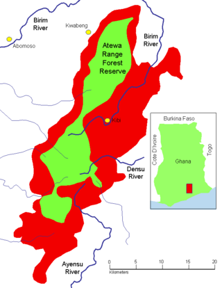
The Atewa Range Forest Reserve is in the Akyem Abuakwa region of southeastern Ghana, near the town of Kibi, and south-west of the Kwahu Plateau which forms the south-west boundary of Lake Volta. The range runs roughly north–south, consisting of steep-sided hills with fairly flat summits. It is the last remains of the Cenozoic peneplain that once covered southern Ghana, and contains ancient bauxitic soils. The range is the site of an important forest reserve, and the source of three major rivers.
Akwatia is the capital of Denkyembour, a district in the Eastern region of south Ghana and west of the Atewa Range in the Birim River basin. Akwatia or Akortia also means "He returned here or there" In the indigenous language formerly known as Oji-Ounji now called Anii. Akwatia has a 2013 settlement population of 23,766 people. Akwatia is the main center of diamond extraction in Ghana. The town is the center of the Denkyembour parliamentary constituency.
Birim Central Municipal District is one of the thirty-three districts in Eastern Region, Ghana. Originally created as an ordinary district assembly in 1988 when it was known as the first Birim South District, which it was created from the former Birim District Council, until the western part of the district was split off to create a new Birim South District, with Akim Swedru as its capital town; thus the remaining part has been renamed as Birim Central Municipal District on 29 February 2008, with Akim Oda as its capital town, which it was elevated to municipal district assembly status on that same year. However on 15 March 2018, the southeast part of the district was split off to become Asene-Manso-Akroso District; thus the remaining part has been retained as Birim Central Municipal District. The municipality is located in the southwest part of Eastern Region and has Akim Oda as its capital town.
Achiase District is one of the thirty-three districts in Eastern Region, Ghana. Originally it was formerly part of the then-larger and first Birim South District in 1988, which was created from the former Birim District Council, until the western part of the district was split off to create a new Birim South District on 29 February 2008; thus the remaining part has been renamed as Birim Central Municipal District, with Akim Oda as its capital town. However on 15 March 2018, the eastern part of the district was split off to create Achiase District; thus the remaining part has been retained as Birim South District. The district assembly is located in the southwest part of Eastern Region and has Achiase as its capital town.
Ghana was initially referred to as the Gold Coast. After attaining independence, the country's first sovereign government named the state after the Ghana Empire in modern Mauritania and Mali. Gold Coast was initially inhabited by different states, empires and ethnic groups before its colonization by the British Empire. The earliest known physical remains of the earliest man in Ghana were first discovered by archaeologists in a rock shelter at Kintampo during the 1960s. The remains were dated to be 5000 years old and it marked the period of transition to sedentism in Ghana. Early Ghanaians used Acheulean stone tools as hunter gatherers during the Early stone age. These stone tools evolved throughout the Middle and Late Stone Ages, during which some early Ghanaians inhabited caves.
