Related Research Articles

Ghana is a West African country in Africa, along the Gulf of Guinea.

Togo is a small Sub-Saharan state, comprising a long strip of land in West Africa. Togo's geographic coordinates are a latitude of 8° north and a longitude of 1°10′ east. It is bordered by three countries: Benin to the east, with 644 km (400 mi) of border; Burkina Faso to the north, with 126 km (78 mi) of border; and Ghana, with 877 km (545 mi) of border. To the south Togo has 56 km (35 mi) of coastline along the Bight of Benin of the Gulf of Guinea in the North Atlantic Ocean. Togo stretches 579 km (360 mi) north from the Gulf and is only 160 km (99 mi) wide at the broadest point. In total, Togo has an area of 56,785 km2 (21,925 sq mi), of which 54,385 km2 (20,998 sq mi) is land and 2,400 km2 (927 sq mi) is water.

The Volta River is the main river system in the West African country of Ghana. It flows south into Ghana from the Bobo-Dioulasso highlands of Burkina Faso. The main parts of the river are the Black Volta, the White Volta, and the Red Volta. In the northwest, the Black Volta forms the international borders between the Ivory Coast, Ghana, and Burkina Faso. The Volta flows southward along the Akwapim-Togoland highlands, and it empties into the Atlantic Ocean at the Gulf of Guinea at Ada Foah. It has a smaller tributary river, the Oti, which enters Ghana from Togo in the east. The Volta River has been dammed at Akosombo for the purpose of generating hydroelectricity. The reservoir named Lake Volta stretches from Akosombo Dam in the south to the northern part of the country, and is the largest man-made reservoir by area in the world.

The Oti River or Pendjari River is an international river in West Africa. It rises in Benin, forms the border between Benin and Burkina Faso, flows through Togo, and joins the Volta River in Ghana.

The Mono River is the major river of eastern Togo.

The Guinean forests of West Africa is a biodiversity hotspot designated by Conservation International, which includes the belt of tropical moist broadleaf forests along the coast of West Africa, running from Sierra Leone and Guinea in the west to the Sanaga River of Cameroon in the east. The Dahomey Gap, a region of savanna and dry forest in Togo and Benin, divides the Guinean forests into the Upper Guinean forests and Lower Guinean forests.

The Upper Guinean forests is a tropical seasonal forest region of West Africa. The Upper Guinean forests extend from Guinea and Sierra Leone in the west through Liberia, Côte d'Ivoire and Ghana to Togo in the east, and a few hundred kilometers inland from the Atlantic coast. A few enclaves of montane forest lie further inland in the mountains of central Guinea and central Togo and Benin.
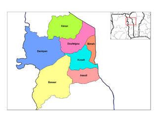
Dankpen is a prefecture located in the Kara Region of Togo. The prefecture covers 2 690 km², with a population in 2010 of 130 723. The prefecture seat is located in Guérin-Kouka. It is split into 12 cantons, Guérin-Kouka, Bapuré, Nandouta, Kidjaboum, Namon, Nawaré, Katchamba, Nampoch, Natchiboré, Natchitikpi, Koulfièkou, and Koutchichéou.

Ghana–Ivory Coast relations refers to the diplomatic relations between Ghana and Ivory Coast. Both nations are members of the United Nations.

The following outline is provided as an overview of and topical guide to Togo:
Mamprusis are an ethnic group in northern Ghana and Togo. Estimates are that there are about 200,000 Mamprusis living in the Northern Regions of Ghana as of 2013, They speak Mampruli, one of the Gur languages. In Ghana, the Mamprusis live mainly in Nalerigu, Gambaga, Walewale, and their surrounding towns and villages in the North East Region. Their origin is in the Upper East Region, principally, Bawku, and they also inhabit parts of the Upper West Region, too.

Denu is a small town which is the capital of Ketu South Municipal, a district on the south-eastern corner of the Volta Region of Ghana, next to Aflao the border town with Togo. The name Denu literally means by the boundary. The town is sandwiched between the sea and lagoon on its south and north respectively.
Kposo language, or Ikposo, is the language of the Akposso people, mainly in the Plateau Region of Togo, west of Atakpamé, but also into eastern Ghana. It is considered one of the Ghana–Togo Mountain languages, but does not have the system of noun classes that is characteristic of other languages in the group.
Tem, or Kotokoli (Cotocoli), is a Gur language spoken in Togo, Ghana, Benin and Burkina Faso. It is used by neighboring peoples. In Ghana the Kotokoli people comes from a northern part of the Volta Region a town called Koue. Koue shares boarder with Togo with a small river which is called the Koue river separating it from Togo.
The Agave are an ethnic group of Ghana, belonging to the Ewe people. They are mainly in the west of the Volta River and north of the Songhor Lagoon.
Several braille alphabets are used in Ghana. For English, Unified English Braille has been adopted. Four other languages have been written in braille: Akan (Twi), Ga, Ewe, and Dagaare. All three alphabets are based on the basic braille letter values of basic Latin alphabet:

The Benin–Togo border is 651 km in length and runs from the tripoint with Burkina Faso in the north down to the Bight of Benin in the south.

The Burkina Faso–Togo border is 131 km in length and runs from the tripoint with Ghana in the west to the tripoint with Benin in the east.

The Ghana–Togo border is 1,098 km in length and runs from the tripoint with Burkina Faso in the north to the Atlantic Ocean in the south.
The Togo women's national under-20 football team represents Togo in international youth women's football competitions.
References
- ↑ Brownlie, Ian (1979). African Boundaries: A Legal and Diplomatic Encyclopedia. Institute for International Affairs, Hurst and Co. pp. 250–79.