
The Great Slave Lake is the second-largest lake in the Northwest Territories of Canada, the deepest lake in North America at 614 metres, and the tenth-largest lake in the world. It is 469 km (291 mi) long and 20 to 203 km wide. It covers an area of 27,200 km2 (10,502 sq mi) in the southern part of the territory. Its given volume ranges from 1,070 km3 (260 cu mi) to 1,580 km3 (380 cu mi) and up to 2,088 km3 (501 cu mi) making it the 10th or 12th largest.

The Western Region is located in south Ghana, spreads from the Ivory Coast border in the west to the Central region in the east, includes the capital and large twin city of Sekondi-Takoradi on the coast, coastal Axim, and a hilly inland area including Elubo. It includes Ghana's southernmost location, Cape Three Points, where crude oil was discovered in commercial quantities in June 2007. The Western Region enjoys a long coastline that stretches from South Ghana's border with Ivory Coast to the Western region's boundary with the Central Region on the east.

Guinea is a traditional name for the region of the African coast of West Africa which lies along the Gulf of Guinea. It is a naturally moist tropical forest or savanna that stretches along the coast and borders the Sahel belt in the north.

Cape Coast Castle is one of about forty "slave castles", or large commercial forts, built on the Gold Coast of West Africa by European traders. It was originally built by the Swedes for trade in timber and gold, but later used in the trans-Atlantic slave trade. Other Ghanaian slave castles include Elmina Castle and Fort Christiansborg. They were used to hold slaves before they were loaded onto ships and sold in the Americas, especially the Caribbean. This "gate of no return" was the last stop before crossing the Atlantic Ocean.

The Brong-Ahafo Region is located in south Ghana. Brong-Ahafo is bordered to the north by the Black Volta river and to the east by the Lake Volta, and to the south by the Ashanti, Eastern and Western regions.The capital of Brong-Ahafo is Sunyani. Brong-Ahafo was created in 1958 from Bono State and named after the dominant and native inhabitants, Akans, Brong and Ahafo.

Salaga is a town and is the capital of East Gonja district, a district in the Northern Region of north Ghana. Salaga has a 2012 settlement population of 25,472 people.
Fort Prinzenstein is a fort located at Keta, Ghana which was used in the slave trade. Many such forts were built in Africa, but Prinzenstein is one of the few that lie east of the Volta River. It was initially built by Danish traders in 1784 for defensive purposes in a war against the Anlo Ewe and to keep the area safe from other colonial powers.

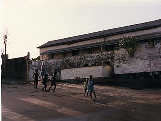
Osu Castle, also known as Fort Christiansborg or simply the Castle, is a castle located in Osu, Accra, Ghana on the coast of the Atlantic Ocean's Gulf of Guinea. The first substantial fort was built by Denmark-Norway in the 1660s, though the castle has changed hands between Denmark-Norway, Portugal, the Akwamu, Britain, and finally post-Independence Ghana, and was rebuilt numerous times. For most of the castle's history, it has been the seat of government in Ghana with some interruptions, the latest when the John Kufuor administration moved the seat of government to Golden Jubilee House after 6 January 2009, which was quickly reversed by the incoming John Atta Mills administration. It also serves as the place where the late president of Ghana John Atta Mills is buried; in a bird sanctuary, overlooking the Atlantic Ocean.

Kalkini is an Upazila of Madaripur District in the Division of Dhaka, Bangladesh.

Mark Twain is a neighborhood of St. Louis, Missouri. It is located between Interstate 70 and Bellefontaine Cemetery.

The history of African-American settlement in Africa extends to the beginnings of ex-slave repatriation to Africa from European colonies in the Americas.
Vaidyaratnam Ayurveda College is Ayurveda college situated in Thaikkattussery near Ollur, Thrissur City of Kerala state. The college is affiliated to the Kerala University of Health Sciences and offers B.A.M.S. degree. The course is recognized by the Central Council of Indian Medicines (CCIM) and is of a duration of 5½ years and 12 months compulsory rotatory internship.Students are admitted for the BAMS course from the list of medical entrance examination conducted by the Government of Kerala. The present intake for the degree programme is 40 students.

Ada Foah is a town on the southeast coast of Ghana, where the Volta River meets the Atlantic Ocean. It's known for palm-lined beaches and estuary islands. Just off the Accra-Aflao motorway, this town is located along the Volta River. It's also the capital of the Ada East District and the seat of the District Assembly.
Fort San Sebastian located in Shama, Ghana is the third oldest fortification in Ghana.
Gwollu is a small town and is the capital of Sissala West district, a district in the Upper West Region of north Ghana. Hilla Limann, a former Ghanaian president was born and raised here.
The history of African Americans in Ghana goes back to individuals such as American civil rights activist and writer W. E. B. Du Bois, who settled in Ghana in the last years of his life and is buried in the capital Accra. Since then, other African Americans who are descended from slaves imported from areas within the present-day jurisdiction of Ghana and neighboring states have applied for permanent resident status in Ghana. As of 2015, the number of African-American residents has been estimated at around 3,000 people, a large portion of whom live in Accra.

Lower Bear River Reservoir in Pioneer, California is created by its own dam, the Lower Bear River Reservoir Dam, and is owned by PG&E. The reservoir lies at 5,800 feet above sea level and covers 727 acres.

