Ghana, officially the Republic of Ghana, is a country in West Africa. It lies adjacent to the Gulf of Guinea and the Atlantic Ocean to the south, sharing a border with Ivory Coast in the west, Burkina Faso in the north, and Togo in the east. Ghana covers an area of 239,567 km2 (92,497 sq mi), spanning diverse ecologies, from coastal savannas to tropical rainforests. With nearly 35 million inhabitants, Ghana is the second-most populous country in West Africa. The capital and largest city is Accra; other significant cities include Kumasi, Tamale, and Sekondi-Takoradi. In 1957 Ghana became the first colony in Sub-Saharan Africa to achieve sovereignty, under the leadership of Kwame Nkrumah.

Ghana is a West African country in Africa, along the Gulf of Guinea.

Kumasi is a city and the capital of the Kumasi Metropolitan Assembly and the Ashanti Region of Ghana. It is the second largest city in the country, with a population of 443,981 as of the 2021 census. Kumasi is located in a rain forest region near Lake Bosomtwe and is located about 200 kilometres (120 mi) from Accra. The city experiences a tropical savanna climate, with two rainy reasons which range from minor to major. Major ethnic groups who lived in Kumasi are the Asante, Mole-Dagbon and Ewe. The current mayor of the metropolitan is Samuel Pyne.

The Gunnison River is located in western Colorado, United States and is one of the largest tributaries of the Colorado River.

The Selenga or Selenge is a major river in Mongolia and Buryatia, Russia. Originating from its headwater tributaries, the Ider and the Delger mörön, it flows for 992–1,024 kilometres (616–636 mi) before draining into Lake Baikal. The Selenga therefore makes up the most distant headwaters of the Yenisey-Angara river system.

The Tano or Tanoé River is a river in Ghana. It flows for 400 kilometres from a town called Traa, a suburb of Techiman, the capital town of Bono East Region of the Republic of Ghana to Ehy Lagoon, Tendo Lagoon and finally Aby Lagoon in Ivory Coast where it enters the Atlantic Ocean. The river forms the last few kilometres of the international land boundary between Ghana and Ivory Coast.

The Carson River is a northwestern Nevada river that empties into the Carson Sink, an endorheic basin. The main stem of the river is 131 miles (211 km) long although the addition of the East Fork makes the total length 205 miles (330 km), traversing five counties: Alpine County in California and Douglas, Storey, Lyon, and Churchill Counties in Nevada, as well as the Consolidated Municipality of Carson City, Nevada. The river is named for Kit Carson, who guided John C. Frémont's expedition westward up the Carson Valley and across Carson Pass in winter, 1844. The river made the National Priorities List (NPL) on October 30, 1990 as the Carson River Mercury Superfund site (CRMS) due to investigations that showed trace amounts of mercury in the wildlife and watershed sediments.

The Río Tinto is a highly toxic river in southwestern Spain that rises in the Sierra Morena mountains of Andalusia. It flows generally south-southwest, reaching the Gulf of Cádiz at Huelva. The Rio Tinto river has a unique red and orange colour derived from its chemical makeup that is extremely acidic and with very high levels of iron and heavy metals.

Gold mining is the extraction of gold by mining.
Environmental issues in Australia describes a number of environmental issues which affect the environment of Australia and are the primary concern of the environmental movement in Australia.

Burke Canyon is the canyon of the Burke-Canyon Creek, which runs through the northernmost part of Shoshone County, Idaho, U.S., within the northeastern Silver Valley. A hotbed for mining in the late-nineteenth and twentieth centuries, Burke Canyon now contains several ghost towns and remnants of former communities along Idaho State Highway 4, which runs northeast through the narrow canyon to the Montana border.

Mining in Ghana is a significant contributor to the nation's economy, accounting for approximately 5% of Ghana's Gross Domestic Product (GDP) and 37% of total exports. Gold dominates the mineral sector, contributing over 90% of total mineral exports. In 2019, Ghana overtook South Africa to become the largest gold producer in Africa, producing 142.4 metric tonnes of gold that year.

The Birim River is one of the main tributaries of the Pra River in Ghana and the country's most important diamond-producing area, flowing through most of the width of the Eastern region. The river rises in the east of the Atewa Range, flows north through the gap between this range and the Kwahu Plateau, then runs roughly south-west until it joins the Pra. It gives its name to the Birimian rock formation, which yields most of the gold in the region. Ghana is the second largest producer of gold in Africa.
Environmental impact of mining can occur at local, regional, and global scales through direct and indirect mining practices. Mining can cause erosion, sinkholes, loss of biodiversity, or the contamination of soil, groundwater, and surface water by chemicals emitted from mining processes. These processes also affect the atmosphere through carbon emissions which contributes to climate change.
The Obuasi Gold Mine is an underground gold mine situated near Obuasi, in the Ashanti Region of Ghana. It was at one time one of the world's ten largest gold mines. The mine is in Obuasi Municipal District, 60 kilometres (37 mi) southwest of the regional capital Kumasi.
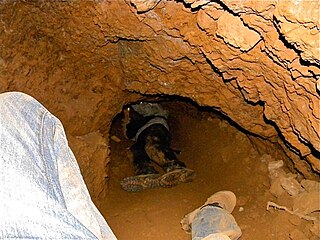
Artisanal and small-scale mining (ASM) is a blanket term for a type of subsistence mining involving a miner who may or may not be officially employed by a mining company but works independently, mining minerals using their own resources, usually by hand.

Mponeng is an ultra-deep tabular gold mine in South Africa in the Witwatersrand Basin of the Gauteng Province. Previously known as Western Deep Levels No1 Shaft, the mine began operations in 1986. It is one of the most substantial gold mines in the world in terms of production and magnitude, reaching over 4 kilometres (2.5 mi) below the surface. At this depth Mponeng takes the title of world's deepest mine from ground level, with aims to deepen the mine beyond 4km in order to reach more reserves. A trip from the surface to its deepest point takes over an hour. An Ecuadorian marathon runner completed a half marathon within the mine in 2017. The mine supports a very large number of people, companies and industries, including entire towns and cities.
Akrofuom is a town on Gyimi River in the Ashanti Region of Ghana. It is the capital of the Akrofuom District. Nana Abena Durowaa I enstooled in December 1999 is the current queenmother of the area. The town is known for the Akrofuom Senior High Technical School. The school is a second cycle institution.

The geology of Ghana is primarily very ancient crystalline basement rock, volcanic belts and sedimentary basins, affected by periods of igneous activity and two major orogeny mountain building events. Aside from modern sediments and some rocks formed within the past 541 million years of the Phanerozoic Eon, along the coast, many of the rocks in Ghana formed close to one billion years ago or older leading to five different types of gold deposit formation, which gave the region its former name Gold Coast.
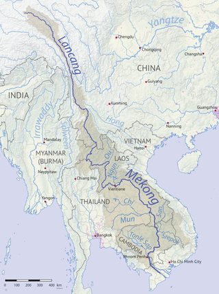
Laos is a nation with plentiful surface water and broad rivers, but outside of cities, water sanitation and accessibility infrastructure is sparse. Few improvements have been made since the end of the Laotian Civil War in 1975, especially compared to peer nations such as Thailand. By 2015, 76% of Laotians nationwide were estimated to have access to “improved” water, while 71% were estimated to have access to “improved” sanitation.
