
Aitutaki, also traditionally known as Araʻura and Utataki, is the second most-populated island in the Cook Islands, after Rarotonga. It is an "almost atoll", with fifteen islets in a lagoon adjacent to the main island. Total land area is 18.05 km2 (6.97 sq mi), and the lagoon has an area of between 50 and 74 km2. A major tourist destination, Aitutaki is the second most visited island of the Cook Islands archipelago.

Rarotonga is the largest and most populous of the Cook Islands. The island is volcanic, with an area of 67.39 km2 (26.02 sq mi), and is home to almost 75% of the country's population, with 10,898 of a total population of 15,040. The Cook Islands' Parliament buildings and international airport are on Rarotonga. Rarotonga is a very popular tourist destination with many resorts, hotels and motels. The chief town, Avarua, on the north coast, is the capital of the Cook Islands.

Pukapuka, formerly Danger Island, is a coral atoll in the northern group of the Cook Islands in the Pacific Ocean. It is one of the most remote islands of the Cook Islands, situated about 1,140 kilometres northwest of Rarotonga. On this small island, an ancient culture and distinct language have been maintained over many centuries. The population of Puka Puka is around 400 people.

Manuae is an uninhabited atoll in the southern group of the Cook Islands, 100 kilometres south-east of Aitutaki. Manuae is not administratively part of Aitutaki, however, it is part of Arutanga-Reureu-Nikaupara Constituency on Aitutaki for electoral purposes only.
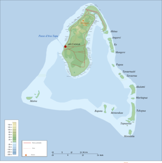
Ee (island) is one of 22 islands in the Aitutaki atoll of the Cook Islands. Located between the smaller islands of Angarei and Mangere, it is the third largest of the Aitutaki motus, after Tekopua and Akaiami, and measures 975m long and up to 410m wide.
Muritapua is one of 22 islands in the Aitutaki atoll of the Cook Islands. It is a small islet located on the eastern perimeter of Aitutaki Lagoon between the larger islands of Akaiami and Tekopua, six kilometres to the southeast of the main island of Aitutaki. The island is 360m long and 150m wide.
Tekopua is one of 22 islands in the Aitutaki atoll of the Cook Islands. It is located on the southeastern perimeter of Aitutaki Lagoon between the smaller islands of Muritapua and Tapuaetai, seven kilometers to the southeast of the main island of Aitutaki. The island is the largest of the Aitutaki atoll, measuring 2,250 meters long and up to 480 meters wide.
Motukitiu is one of 22 islands in the Aitutaki atoll of the Cook Islands. It is a small island located at the southeastern tip of Aitutaki Lagoon, one kilometre to the south of the larger island of Tekopua and eight kilometres to the southeast of the main island of Aitutaki. The island is 450m long and 300m wide.
Moturakau is one of 22 islands in the Aitutaki atoll of the Cook Islands. It is located in the southeast of Aitutaki Lagoon between the larger islands of Rapota and Tekopua, six kilometres to the southeast of the main island of Aitutaki. The island is 460m long and 120m wide.
Rapota is one of 22 islands in the Aitutaki atoll of the Cook Islands. It is located in the south of Aitutaki Lagoon to the west of the smaller island of Moturakau, six kilometres to the southeast of the main island of Aitutaki. The island is volcanic, with a core of basalt surrounded by basalt boulders.

Maina is one of 22 islands in the Aitutaki atoll of the Cook Islands. It is located at the southwestern extreme of Aitutaki Lagoon, five kilometres to the southwest of the main island of Aitutaki. The island is a sand cay 710m long and up to 310m wide. In front of Maina island stands a sandbar known as "Honeymoon Island" named after a Canadian couple who decided to get married here.
Akitua is one of 22 islands in the Aitutaki atoll of the Cook Islands. It is on the northeastern perimeter of Aitutaki Lagoon and is 750m long and up to 310m wide. The island is owned by The Aitutaki Lagoon Resort & Spa, a 5 star hotel equipped with luxury bungalows, restaurant and bar. It is known for its beautiful turquoise, indigo blue, beach.
Angarei is one of 22 islands in the Aitutaki atoll of the Cook Islands. It is located on the northeastern perimeter of Aitutaki Lagoon to the north of the larger island of Ee, three kilometres to the east of the main island of Aitutaki. The island is 480m long by 400m wide.
Mangere is one of 22 islands in the Aitutaki atoll of the Cook Islands. It is located on the northeastern perimeter of Aitutaki Lagoon to the south of the larger island of Ee, three kilometres to the east of the main island of Aitutaki. The island is 350m across.
Papau is one of 22 islands in the Aitutaki atoll of the Cook Islands. It is located on the eastern perimeter of Aitutaki Lagoon, four kilometres to the east of the main island of Aitutaki. The island is 400m long and 200m wide.
Tavaeruaiti is one of 22 islands in the Aitutaki atoll of the Cook Islands. It is located on the eastern perimeter of Aitutaki Lagoon to the north of the larger island of Tavaerua, four kilometres to the east of the main island of Aitutaki. The island is 250m long and 210m wide.
Tavaerua is one of 22 islands in the Aitutaki atoll of the Cook Islands. It is located on the eastern perimeter of Aitutaki Lagoon to the south of the smaller island of Tavaeruaiti, four kilometres to the east of the main island of Aitutaki. The island is 290m wide and 500m long and has an elevation of 7 metres (23 ft) above sea level.
Akaiami is one of 22 islands in the Aitutaki atoll of the Cook Islands. It is located on the eastern perimeter of Aitutaki Lagoon to the north of the smaller islands of Muritapua, five kilometres to the southeast of the main island of Aitutaki. It is the second-largest of the Aitutaki motus, after Tekopua, measuring 1120m long and 410m wide. During the 1950s the island was used as a stopover for TEAL flying boats on the famous Coral Route. These operations ceased in 1960, and the only reminder are the remains of the purpose-built jetty.
The Ootu Peninsula, though connected to the main island of Aitutaki atoll of the Cook Islands, may in many respects be considered as one of the reef islands, being the largest and longest of them. It is located at the northern end of the eastern perimeter of Aitutaki Lagoon to the north and then west of the northernmost true reef island, Akitua, from which is separated by a channel 50 metres wide and less than two metres deep. The southernmost point of the peninsula is called Aumoana. The northernmost point of the peninsula, Teaumera, is also the northernmost point of Aitutaki as a whole. In the northeast is Kopu a Ruatapu, a boat passage through the fringing coral reef.
Tapuaeta cay is one of 22 islands in the Aitutaki atoll of the Cook Islands. It is a sand cay located on the eastern perimeter of Aitutaki Lagoon, to the west of Tapuaetai, and is 190m long and up to 70m wide.


