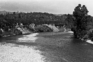
The Inangahua River is located in the northwest of New Zealand’s South Island. It is a major tributary of the Buller River, which it joins at the town of Inangahua Junction.
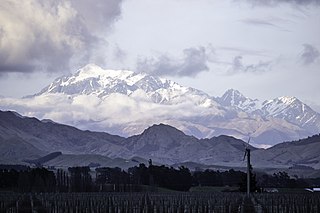
Tapuae-o-Uenuku, formerly Mount Tapuaenuku, is the highest peak in the northeast of New Zealand's South Island. The name translates from Māori as "footprint of the rainbow", though is usually regarded as being named after Chief Tapuaenuku.
Reed Publishing (NZ) Ltd was one of the leading publishers in New Zealand. It was founded by Alfred Hamish Reed and his wife Isabel in 1907. Reed's nephew Alexander Wyclif Reed joined the firm in 1925. It was a New Zealand literature specialist and general titles publisher, releasing over 100 titles a year including a number of significant New Zealand authors such as Barry Crump, Janet Frame and Witi Ihimaera.
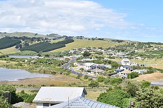
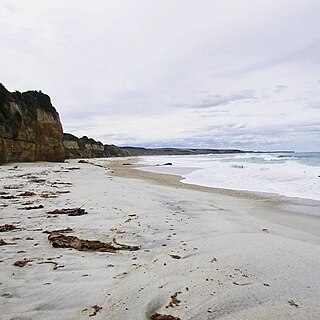
Katiki is a small settlement in North Otago, New Zealand. It lies between the townships of Palmerston and Hampden on State Highway 1 at the northern end of Katiki Beach, close to the Moeraki Peninsula. The tip of the peninsula, Katiki Point, is the site of Katiki Point Lighthouse. The scenic reserve of Trotter's Gorge is located just inland of Katiki.
The following lists events that happened during 1831 in New Zealand.

St Leonards is a suburb of the New Zealand city of Dunedin. It is located close to the northern shore of the Otago Harbour and on the hilly slopes above the harbour. St Leonards is 8.5 kilometres (5.3 mi) northeast of Dunedin's city centre, between the small settlement of Burkes and Sawyers Bay. St Leonards was named by early settler David Carey for the birthplace of his wife, the English town of St Leonards-on-Sea, on the Sussex coast.
Ocean Grove, also known as Tomahawk, is a suburb in the southeast of the New Zealand city of Dunedin. A semi-rural residential suburb on the Pacific coast at the southwestern end of the Otago Peninsula, Ocean Grove is located 6.5 kilometres (4.0 mi) southeast of Dunedin city centre.
The Wharekōpae River is located in the northeast of New Zealand's North Island. A tributary of the Waikohu River, it rises on the slopes of Maungatapere, a 1,050-metre (3,440 ft) peak at the northeastern end of the Huiarau Range, and flows east, reaching the Waikohu River at the settlement of Waikohu, west of Te Karaka.
The Cust River is a river in the Canterbury region of New Zealand. It flows east across the upper Canterbury Plains from its source north of the town of Oxford, New Zealand, flowing into the Cam River / Ruataniwha close to the town of Rangiora. The small town of Cust lies on the banks of the river. The lower part of the river, to the south-west of Rangiora, is diverted into a channel and called the "Main Drain". The channel was built in 1862 to drain the swampy land between Rangiora and the Waimakariri River, and when it was enlarged in 1868 it accidentally captured the Cust.
The Gorge River is a river on the West Coast of New Zealand. It arises in the Hope Blue River Range and flows south-west into the Tasman Sea. Its tributaries include the Duncan River and Jerry River. It passes through Cascade Forest. Its mouth is about 15 km north-east of Awarua Point. The Gorge Islands are very small islands near the mouth. At its mouth, it is a fast tidal river.
The small settlement of Caberfeidh is located in The Catlins, in the Otago region of New Zealand's South Island. The site of a former railway station on the Catlins Branch Line, it is sited close to a tributary of the Maclennan River, 5 kilometres north of the coast at Tahakopa Bay and 12 kilometres southwest of Owaka.
Waiwera South is a small settlement in the South Island of New Zealand, close to the boundary between the Otago and Southland regions. The settlement is located between Balclutha and Clinton, immediately to the south of State Highway 1, between branches of the Waiwera River and Kaihiku Stream, two minor tributaries of the Clutha River. The South Island Main Trunk railway also runs through the township. The settlement's population is around 100.

Karaka Bays is a suburb of Wellington, New Zealand. It lies on the northeast coast of the Miramar Peninsula, 6 km east-south-east of the city centre, and has an expansive view of Wellington Harbour. It takes its name from a New Zealand native tree, the karaka or New Zealand laurel.
Kyeburn is a small settlement in Otago, in the South Island of New Zealand. It lies on the Maniototo, a wide, high plain stretching from the end of the Strath-Taieri valley.
Wangaloa is a small coastal settlement in South Otago, New Zealand. It is located to the north of the mouths of the Clutha River the beach area, close to the town of Kaitangata. There is access to Wangaloa Beach from the Kaitangata Golf course. Wangaloa is connected to Toko Mouth, 10 kilometres (6.2 mi) to the north, by a coastal road, and to Kaitangata, 5 kilometres (3.1 mi) to the west, by a road which crests a low range of coastal hills.
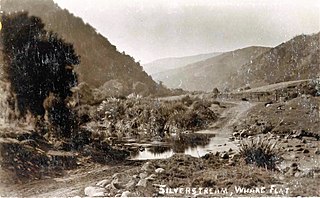
Whare Flat is a locality some 15 km to the northwest of Dunedin city centre, in the South Island of New Zealand. It is located at a widening of the Silver Stream's valley amid the foothills of the Silverpeaks.
Oaro is a settlement close to the Pacific Ocean Coast of north Canterbury, in the South Island of New Zealand.

Kainga is a settlement on the southern bank of the Waimakariri River, just north of Christchurch, in Canterbury, New Zealand. It lies immediately to the south of Kaiapoi, on a small road leading northeast from SH 1
Moneymore is a small farming community in South Otago, New Zealand. It is located 5 kilometres to the southwest of Milton, to the south of SH 1.
Waipapakauri is a small settlement in the Far North District of New Zealand. It is located on State Highway 1 at the isthmus of the Aupouri Peninsula. The larger settlement of Awanui lies to the southeast. Waipapakauri is some 12 kilometres to the north of Kaitaia, the nearest town.
