
Kaohsiung is a coastal city in southern Taiwan. It is officially a special municipality with an area of 2,952 km2 (1,140 sq mi) stretching from the coastal urban centre to the rural Yushan Range. As of 2018, the municipality has a population of 2.77 million, making it the third most populous administrative division in Taiwan.

Oolong is a traditional semi-oxidized Chinese tea produced through a process including withering the plant under strong sun and oxidation before curling and twisting. Most oolong teas, especially those of fine quality, involve unique tea plant cultivars that are exclusively used for particular varieties. The degree of oxidation, which varies according to the chosen duration of time before firing, can range from 8–85%, depending on the variety and production style. Oolong is especially popular in south China and among Chinese expatriates in Southeast Asia, as is the Fujian preparation process known as the Gongfu tea ceremony.
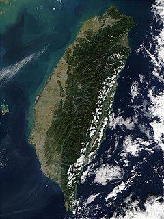
Taiwan, formerly known as Formosa, is an island in East Asia; located some 180 kilometres off the southeastern coast of mainland China across the Taiwan Strait. It has an area of 36,104 km2 (13,940 sq mi), which includes other nearby islands such as Penghu. The East China Sea lies to the north, the Philippine Sea to the east, the Luzon Strait directly to the south and the South China Sea to the southwest. The island makes up 99% of the current territory of the Republic of China, which is also known as "Taiwan".

Taipei, officially known as Taipei City, is the capital and a special municipality of Taiwan. Sitting at the northern tip of the island, Taipei City is an enclave of the municipality of New Taipei City that sits about 25 km (16 mi) southwest of the northern port city Keelung. Most of the city is located in the Taipei Basin, an ancient lakebed. The basin is bounded by the relatively narrow valleys of the Keelung and Xindian rivers, which join to form the Tamsui River along the city's western border.
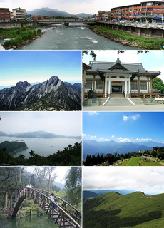
Nantou County is the second largest county of Taiwan. It is also the only landlocked county in Taiwan. Its name derives from the Hoanya Taiwanese aboriginal word Ramtau. Nantou County is officially administered as a county of Taiwan.

New Taipei City is a special municipality and the most populous city in Taiwan. Located in northern Taiwan, the city includes a substantial stretch of the island's northern coastline and surrounds the Taipei Basin, making it the second largest special municipality by area, behind Kaohsiung. New Taipei City is bordered by Keelung to the northeast, Yilan County to the southeast, and Taoyuan to the southwest. It completely surrounds Taipei. Banqiao District is its municipal seat and biggest commercial area. Until 2010, the area that roughly corresponds to the present New Taipei City was known as Taipei County.
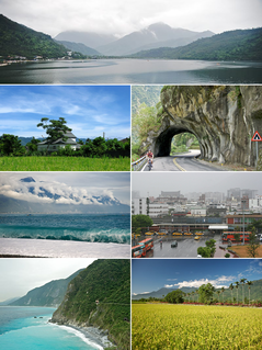
Hualien County is a county on the east coast of Taiwan. It is the largest county by area, yet due to its mountainous terrain, has one of the lowest populations in the country. The county seat and largest city is Hualien City.

Pingtung County is a county in Southern Taiwan known for its agriculture and tourism. In recent years, it promotes specialties such as tuna and wax apples. Pingtung is where Kenting National Park, the oldest and the largest national park in Taiwan established in 1984, is located. The capital of the county is Pingtung City.

Miaoli County is a county in western Taiwan. Miaoli is adjacent with Hsinchu County and Hsinchu City to the north, Taichung to the south, and borders the Taiwan Strait to the west. The Council for Economic Planning and Development of Taiwan classifies Miaoli as a county of Central Taiwan, while the Taiwan Central Weather Bureau classifies Miaoli as a county of the North. Miaoli City is the capital of the county, and is also known as "Mountain Town", owing to the number of mountains nearby, making it a destination for hiking.

Yushan, also Mount Jade or Mount Yu, is the highest mountain in Taiwan at 3,952 metres (12,966 ft) above sea level, giving Taiwan the fourth highest maximum elevation of any island in the world. The obsolete name of Mount Morrison is thought to have been named in honor of the 19th century missionary Robert Morrison. Today, the mountain is generally referred to as Yushan or Mt. Jade.

The Paiwan are an indigenous people of Taiwan. They speak the Paiwan language. In 2014, the Paiwan numbered 96,334. This was approximately 17.8% of Taiwan's total indigenous population, making them the second-largest indigenous group.
Townships are the third-level administrative subdivisions of counties of Taiwan, along with county-controlled cities. After World War II, the townships were established from the following conversions on the Japanese administrative divisions:

The Central Mountain Range, also known as the Zhongyang Range or Chungyang Range, is the principal range of mountains in Taiwan. It runs from the north of the island to the south. Due to this separation, connecting between the west and east is not very convenient. The tallest peak of the range is Xiuguluan Mountain, 3,860 m (12,664 ft).

Shizi Township is a mountain indigenous township in Pingtung County, Taiwan. It is the largest township of the county. The main population is the Paiwan people of the Taiwanese aborigines.
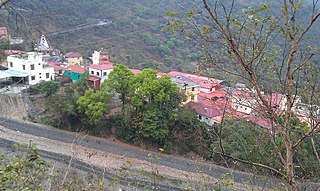
Maolin District is a mountain indigenous district of Kaohsiung, Taiwan. Maolin is one of the least populated districts in Taiwan, since it is located just to the south of the Central Mountain Range. The height ranges from 230 meters to 2700 meters above sea level, with a hot tropical and humid weather. The main population of Maolin district is the Rukai people of the Taiwanese aborigines. Maolin is well suited for tourism due to its unique scenery and ecology. In 2001 December, it was officially made the Maolin National Park of Taiwan.

Ang LeeOBS is a Taiwanese film director and screenwriter. Lee's work is known for its emotional charge, which critics believe is responsible for his success in offsetting cultural barriers and achieving international recognition.
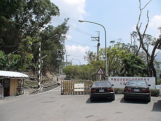
Sandimen Township is a mountain indigenous township in Pingtung County, Taiwan. The population of the township is majority Paiwan with a substantial Rukai minority.


