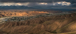
Naryn is the regional administrative center of Naryn Region in central Kyrgyzstan. Its area is 84 square kilometres (32 sq mi), and its estimated population was 41,178 as of January 2021. The town was established as a fortress on the caravan route in 1868. It is situated on both banks of the river Naryn, which cuts a picturesque gorge through the town. The city has two regional museums and some hotels, but is otherwise residential.

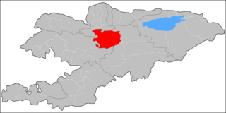
Naryn Region is the largest region of Kyrgyzstan. It is located in the east of the country and borders with Chüy Region in the north, Issyk-Kul Region in the northeast, Xinjiang Uyghur Autonomous Region of China in the southeast, Osh Region in the southwest, and Jalal-Abad Region in the west. Its capital is Naryn. Its total area is 44,160 km2 (17,050 sq mi). The resident population of the region was 292,140 as of January 2021.

Osh Region is a region of Kyrgyzstan. Its capital is Osh, which is not part of the region. It is bounded (clockwise) by Jalal-Abad Region, Naryn Region, China (Xinjiang), Tajikistan, Batken Region, and Uzbekistan. Its total area is 28,934 km2 (11,171 sq mi). The resident population of the region was 1,391,649 as of January 2021. The region has a sizeable Uzbek minority.

At-Bashy is a village in the Naryn Region of Kyrgyzstan, about 35km southwest of Naryn on the main highway to the Torugart Pass. It is the administrative seat of At-Bashy District. The At-Bashy Range to the south extends to Lake Chatyr-Kul. The river At-Bashy comes in from the east and then runs northwest through a gorge in the Baybiche-Too range to join the Naryn near Dostuk. It is the last considerable settlement before the Chinese border. The highway, built in 1906, runs southwest between the Baybiche-Too and At-Bashy ranges before turning south and then east to reach the pass. Its population was 14,655 in 2021. At-Bashy is also known for the white honey collected from its highlands, based on the esparcet honey plants.
Dostuk is a village in Naryn District of Naryn Region of Kyrgyzstan on the river Naryn and highway A361 about 35 km west of Naryn. Its population was 750 in 2021. Until 2012 it was an urban-type settlement.
Emgek-Talaa is a village in the Naryn Region of Kyrgyzstan. It is part of the Naryn District. Its population was 1,866 in 2021.
Kara-Köl is a city in Jalal-Abad Region of Kyrgyzstan. It is a city of regional significance, not part of a district. Its area is 1,050 square kilometres (410 sq mi), and its resident population was 26,901 in 2021. Kara-Köl consists of the town proper, the urban-type settlement Ketmen-Töbö and the village Jazy-Kechüü.
Kyzyl-Beyit is a remote village in the Jalal-Abad Region of Kyrgyzstan. It is part of the Aksy District. It is bordered by mountains on one side and the Naryn River on the other. Transportation to and from the village mainly relies on ferries and boats. Its population was 342 in 2021.
Ak-Kuduk is a village in the Naryn District, Naryn Region of Kyrgyzstan. Its population was 718 in 2021.
Chaek is a village in Naryn Region of Kyrgyzstan on the A361 highway which crosses the north of the region. Its population was 3,762 in 2021. It is the center of the Jumgal District. It is about 100km west of Kochkor and 45km west of Lake Song-Köl. It is the largest of several villages in an agricultural valley. Further west the scenery becomes more dramatic.

Kochkor is a large village in northern Naryn Region of Kyrgyzstan. It is the administrative centre of Kochkor District. The village was established in 1909 as Stolypino and renamed to Kochkor in 1917. Altitude 1,800 m. Its population was 11,373 in 2021. It is on the main A365 highway from Torugart Pass (China) north to Bishkek. About 7 km west A367 branches west toward Jalal-Abad Region and the Ferghana Valley. About 25 km northeast along the highway is the Orto-Tokoy reservoir and about 45 km northeast is Balykchy on Lake Issyk-Kul. The village is a base for excursions into the high country and tourist infrastructure is fairly well developed. There is a regional museum.
Baetov is a village and the administrative seat of Ak-Talaa District in Naryn Region of Kyrgyzstan. Its population was 10,682 in 2021. It lies on the Naryn valley road about half-way from Naryn to Kazarman. At this point, a road branches south to Baetov on an outwash plain in the mountains. A jeep road goes south over a 3,268m pass to the At-Bashy valley and A365 to the Torugart Pass.
Jumgal is a district of Naryn Region in central Kyrgyzstan. The administrative seat lies at Chaek. Its area is 4,803 square kilometres (1,854 sq mi), and its resident population was 44,866 in 2021. It is a mountainous district. Its main rivers are the Kökömeren and its tributaries Jumgal, Suusamyr and Batysh Karakol.

Naryn District is a district of Naryn Region in central-southern Kyrgyzstan. The administrative seat lies at the city of Naryn, which is not part of the district. Naryn District was established in its borders in 1930. It borders At-Bashy District to the south, Ak-Talaa District to the west, Kochkor District to the north, Tong District to the north-east, Jeti-Ögüz District to the east, and Lake Song Köl to the north-west. Its area is 10,502 km2 (4,055 sq mi), and its resident population was 49,955 in 2021.
Ak-Bulung is a village in Naryn District of Naryn Region of Kyrgyzstan. Its population was 343 in 2021.
Naryn is a village in Jalal-Abad Region of Kyrgyzstan. It is part of the Aksy District. Its population was 11,306 in 2021. It is situated on the right bank of the river Naryn, adjacent to Kyzyl-Jar and across from Uchqoʻrgʻon (Uzbekistan).
Bayzak is a village in Naryn Region of Kyrgyzstan. It is part of the Jumgal District. Its population was 6,386 in 2021.
Tengdik is a village in Naryn Region of Kyrgyzstan. It is part of the Kochkor District and the Kochkor rural community. Its population was 5,052 in 2021.
Ming-Bulak is a settlement in the Naryn Region of Kyrgyzstan. It is part of the Naryn District. Its population was 1,438 in 2021.
Emgekchil is a settlement in the Naryn Region of Kyrgyzstan. It is part of the Naryn District. The population of the settlement was 3,353 in 2021.

