
Saharsa is a city and municipal corporation in the Saharsa District in the eastern part of the state of Bihar, India. It is situated near the eastern banks of the Kosi River. It serves as the administrative headquarters for the Saharsa District and is also the Divisional headquarters of the Kosi Division.

Sitamarhi is one of the districts in the Mithila region of the Indian state of Bihar, India. Dumra is the administrative headquarters of this district. The district is a part of the Tirhut Division and is located along the border of Nepal.

Seoni is a city and a municipality in Seoni district in the Indian state of Madhya Pradesh. This tribal household dominated district was formed in the year 1956.

Newarthill is a village in North Lanarkshire, Scotland, situated roughly three miles north-east of the town of Motherwell. It has a population of around 6,200. Most local amenities are shared with the adjacent villages of Carfin, Holytown and New Stevenston which have a combined population of around 20,000 across the four localities.

Woodcroft is a metropolitan suburb of Adelaide, South Australia, located 20 km south of the Central Business District of Adelaide. It is bordered to the north by Reynell Road, to the south by Bains Road, to the west by Panalatinga Road and by the Hills Face Zone to the east. The Panalatinga Creek also runs through the suburb.

Irchester is a village and civil parish in North Northamptonshire, two miles (3 km) south-east of Wellingborough and two miles south-west of Rushden. The population of the village at the 2011 Census was 5,706 and estimated in 2019 at 5,767. Little Irchester and Knuston also lie in the parish.
West Mambalam is a residential and commercial area in Chennai, India. It is known for its shops, bazaars and Hindu temples. It is bounded by Kodambakkam to the north and Saidapet to the south. T. Nagar and Nandanam stretch all along its eastern frontiers while Ashok Nagar lies to its west. The Ayodhya Mandapam is an important landmark.

Pakala is a town in Tirupati district of the Indian state of Andhra Pradesh. It is the mandal headquarters of Pakala mandal. It comes under Tirupati revenue division.
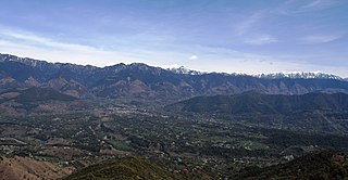
Jogindernagar, or Jogindar Nagar, is a municipality, and a sub district in Mandi district in the Indian state of Himachal Pradesh. Named after Raja Joginder Sen, the hill station is the terminus of the 163-kilometre-long (101 mi) Kangra Valley narrow-gauge railway. Jogindernagar is the third-largest city in the Mandi district. The only city in Asia with three hydro-electric power stations, its nickname is "The City of Powerhouses".

Kirknewton is a village formerly in the county of Midlothian and, since 1975, in West Lothian, Scotland. The population of the Kirknewton Community Council district is 2200, which includes the village and surrounding areas. It lies south of the A71 from Edinburgh to Livingston, and north of the A70, the high-level road that runs along the north side of the Pentland Hills from Edinburgh to Carnwath and Lanark. Much of the village stands back from the B7031, which links the two main "A" roads. To the south-east of the village is Morton.
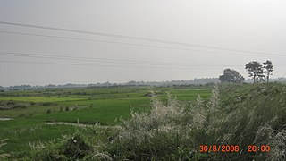
Dheng is a village in Bihar, India. It is situated 25 km. away towards west from Sitamarhi on the bank of the Bagmati River, which is connected to the rest of the district center via broad-gauge rail network. It has: at the east side, the Maniyari and Vasant Gachhi Tola; to the west side, Bel, Bengahi and Adamwan; to the north side is Nepal and Jamla; and to the south is Gamhariya and Kharahia tola.

Leziate is a village and civil parish in the English county of Norfolk. The village is 44 miles (71 km) west of Norwich, 5.7 miles (9.2 km) east of King's Lynn and 106 miles (171 km) north-north-east of London. The Village is located a small distance south of the B1145 a route which runs between King's Lynn and Mundesley. The nearest railway station is at King's Lynn for the Fen Line which runs between King's Lynn and Cambridge. The nearest airport is Norwich International Airport. The parish of Leziate in the 2001 census, has a population of 581, including Ashwicken and increasing to 592 at the 2011 census.
Raghopur is a community development block in Vaishali district of Bihar. Situated between two streams of the Ganges river, it is a river island. It is connected to Patna by Pipa pul. Ancient name of Raghopur is Kotigram.

Rhenock is a town, just 35 km from Pakyong City in the Pakyong district in Sikkim, India, located on the border with the Kalimpong district of West Bengal. It lies 63 kilometres east of Gangtok, and 47 kilometres north of Kalimpong on the way to Jelepla Pass at an altitude of 1,040 metres. The word Rhe-nock means Black Hill. Situated in the extreme east of Sikkim, Rhenock witnessed the establishment of the first police outpost in the state.

Supedi is a village located in the district of Rajkot in the Indian state of Gujarat. Its population is about 7764 persons, living in around 1750 households.

Kumbhariya is a village of historical, archaeological and religious importance with cultural heritage in Danta Taluka of Banaskantha district, Gujarat, India.
Harinagar is a small village in Bihar, India.
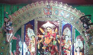
Navtol is a small village of sarisab-pahi west panchayat of Pandaul block in Madhubani district of Bihar State in India. It is located 1.5 kilometres north of National Highway-57, Ganguli chawk. The village Navtol "Sarisabpahi" is situated at 16–17 kilometers south-east from district headquarters (Madhubani), in Darbhanga commissionary of state Bihar. It is an important Tola of revenue village Sarisab alise Sarisab-pahi. Now there are two Panchayats, Sarisab-pahi to the East and Sarisab-pahi to the West. Other Tolas are Pahitol and Bitthotol. Total area of Navtol now is 1.5 km2. The population of this village is 6500–7000. Hindi, Maithili and English are spoken and written in this area, Maithili being the main language of this village. And scripts of this village are Devnagari, Roman and Mithilakshar (tirhuta). Durga pooja celebrated in Navtol, every year in "Ashwin" since 1840. It is near jhanjharpur railway station. This place is famous for durgapuja.

Birpur is a village in Vaishali district, Bihar which is situated at the river island called Raghopur Diyara Island. It is one of the largest village in Raghopur community block. People of this village are mostly dependent on agriculture. People in this area has long tradition of joining armed forces. Its population is approximately 20,000 and peoples of this village are living their life in peaceful manner. Most of the Villagers work outside and bring revenue to this place which helps flourish the local community and enhance purchasing power. Birpur comes under Raghopur community block and a police station is Jurawanpur. It is the second largest village in the Raghopur block in terms of area and population. its pin code is 844508. Education rate of this village is quite low around 33% overall. Higher education facility is not available in the village and also there are no major hospitals, only private clinics and some small hospitals. Thethi is the only language which people speaks. It is spread over in the area of 20 km.

Nimta is a Census Town in North Dumdum Municipality in Barrackpore II CD block in Barrackpore subdivision of North 24 Parganas district in the Indian state of West Bengal. It is a part of the area covered by Kolkata Urban Agglomeration.