
Manhattan is the most densely populated and geographically smallest of the five boroughs of New York City. Coextensive with New York County, Manhattan is the smallest county by geographical area in the U.S. state of New York. Located almost entirely on Manhattan Island near the southern tip of the state, Manhattan constitutes the center of the Northeast megalopolis and the urban core of the New York metropolitan area. Manhattan serves as New York City's economic and administrative center and has been described as the cultural, financial, media, and entertainment capital of the world.

Brooklyn is a borough of New York City located at the westernmost end of Long Island in the State of New York. Formerly an independent city, the borough is coextensive with Kings County, one of twelve original counties established under British rule in 1683 in the then Province of New York. As of the 2020 United States census, the population stood at 2,736,074, making it the most populous of the five boroughs of New York City, and the most populous county in the state. Brooklyn, at 37,339.9 inhabitants per square mile (14,417.0/km2), is the second most densely populated county in the U.S. after Manhattan, as of 2022. Had Brooklyn remained an independent city, it would now be the fourth most populous American city after the rest of New York City, Los Angeles, and Chicago.

Metropolis is a fictional city appearing in American comic books published by DC Comics, best known as the home of Superman and his closest allies and some of his foes. First appearing by name in Action Comics #16, Metropolis is depicted as a prosperous and massive city in the Northeastern United States, in close proximity to Gotham City. In recent years, it has been stated to be located in New York.

Midtown Manhattan is the central portion of the New York City borough of Manhattan, serving as the city's primary central business district. Midtown is home to some of the city's most prominent buildings, including the Empire State Building, the Chrysler Building, the Hudson Yards Redevelopment Project, the headquarters of the United Nations, Grand Central Terminal, and Rockefeller Center, as well as several prominent tourist destinations, including Broadway, Times Square, and Koreatown. Penn Station in Midtown Manhattan is the busiest transportation hub in the Western Hemisphere.

The South Street Seaport is a historic area in the New York City borough of Manhattan, centered where Fulton Street meets the East River, within the Financial District of Lower Manhattan. The Seaport is a designated historic district. It is part of Manhattan Community Board 1 in Lower Manhattan, and is next to the East River to the southeast and the Two Bridges neighborhood to the northeast.

State University of New York at Oswego is a public university in Oswego, New York. It has a total student population of 6,756 and the campus size is 700 acres.

East Williamsburg is a name for the area in the northwestern portion of Brooklyn, New York City, United States. East Williamsburg consists roughly of what was the 3rd District of the Village of Williamsburgh and what is now called the East Williamsburg In-Place Industrial Park (EWIPIP), bounded by the neighborhoods of Northside and Southside Williamsburg to the west, Greenpoint to the north, Bushwick to the south and southeast, and both Maspeth and Ridgewood in Queens to the east. Much of this area is still referred to as either Bushwick, Williamsburg, or Greenpoint with the term East Williamsburg falling out of use since the 1990s.

Dumbo is a neighborhood in the New York City borough of Brooklyn. It encompasses two sections: one situated between the Manhattan and Brooklyn Bridges, which connect Brooklyn to Manhattan across the East River, and another extending eastward from the Manhattan Bridge to the Vinegar Hill area. The neighborhood is bounded by Brooklyn Bridge Park to the north, the Brooklyn Bridge to the west, Brooklyn Heights to the south, and Vinegar Hill to the east. Dumbo is part of Brooklyn Community Board 2.

Third Avenue is a north-south thoroughfare on the East Side of the New York City borough of Manhattan, as well as in the center portion of the Bronx. Its southern end is at Astor Place and St. Mark's Place. It transitions into Cooper Square, and further south, the Bowery, Chatham Square, and Park Row. The Manhattan side ends at East 128th Street. Third Avenue is two-way from Cooper Square to 24th Street, but carries only northbound (uptown) traffic while in Manhattan above 24th Street; in the Bronx, it is again two-way. However, the Third Avenue Bridge carries vehicular traffic in the opposite direction, allowing only southbound vehicular traffic, rendering the avenue essentially non-continuous to motor vehicles between the boroughs.
Isaac Newton Phelps Stokes was an American architect. Stokes was a pioneer in social housing who co-authored the 1901 New York tenement house law. For twenty years he worked on The Iconography of Manhattan Island, a six-volume compilation that became one of the most important research resources about the early development of the city. His designs included St. Paul's Chapel at Columbia University and several urban housing projects in New York City. He was also a member of the New York Municipal Arts Commission for twenty-eight years and president for nine of these.

Fast Company is a monthly American business magazine published in print and online that focuses on technology, business, and design. It publishes six print issues per year.
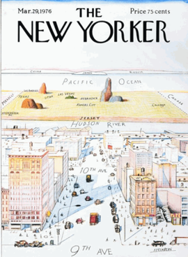
View of the World from 9th Avenue is a 1976 illustration by Saul Steinberg that served as the cover of the March 29, 1976, edition of The New Yorker. The work presents the view from Manhattan of the rest of the world showing Manhattan as the center of the world. The work of art is an artistic representation of distorted self-importance relative to one's true place in the world that is a form of perception-based cartography humor.
Hagstrom Map, based in Maspeth, Queens, was the best-selling brand of road maps in the New York City metropolitan area from the mid-20th to early 21st century. The New York Times in 2002 described Hagstrom's Five Borough Atlas as New York City's "map of record" for the previous 60 years.

A road map, route map, or street map is a map that primarily displays roads and transport links rather than natural geographical information. It is a type of navigational map that commonly includes political boundaries and labels, making it also a type of political map. In addition to roads and boundaries, road maps often include points of interest, such as prominent businesses or buildings, tourism sites, parks and recreational facilities, hotels and restaurants, as well as airports and train stations. A road map may also document non-automotive transit routes, although often these are found only on transit maps.

The Castello Plan – officially entitled Afbeeldinge van de Stadt Amsterdam in Nieuw Neederlandt – is an early city map of what is now the Financial District of Lower Manhattan from an original of 1660. It was created by Jacques Cortelyou, a surveyor in what was then called New Amsterdam – later renamed by the settlers of the Province of New York settlement as New York City, with its Fort Amsterdam, the center of trade and government. The map that is presently in the New York Public Library is a copy created around 1665 to 1670 by an unknown draughtsman from a lost Cortelyou original.

Childs Restaurants was one of the first national dining chains in the United States and Canada, having peaked in the 1920s and 1930s with about 125 locations in dozens of markets, serving over 50,000,000 meals a year, with over $37 million in assets at the time. Childs was a pioneer in a number of areas, including design, service, sanitation, and labor relations. It was a contemporary of food service companies such as Horn & Hardart, and a predecessor of companies such as McDonald's.

John Henry Bufford (1810–1870) was a lithographer in 19th-century Boston, Massachusetts.

The New York State Supreme Court Building, originally known as the New York County Courthouse, is located at 60 Centre Street on Foley Square in the Civic Center neighborhood of Manhattan in New York City. It houses the Civil and Appellate Terms of the New York State Supreme Court for the state's First Judicial District, which is coextensive with Manhattan, as well as the offices of the New York County Clerk.

Many transit maps for the New York City Subway have been designed since the subway's inception in 1904. Because the subway was originally built by three separate companies, an official map for all subway lines was not created until 1940, when the three companies were consolidated under a single operator. Since then, the official map has undergone several complete revisions, with intervening periods of comparative stability.
The Lincoln Arcade was a commercial building near Lincoln Square in the Upper West Side of Manhattan, New York City, just west of Central Park. Built in 1903, it was viewed by contemporaries as a sign of the northward extension of business-oriented real estate ventures, and the shops, offices, and other enterprises.


