Te Anga

Last updated

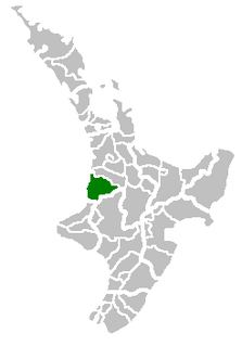
Te Anga is a rural community in the Waitomo District and Waikato Region of New Zealand's North Island. [1]

Waitomo District Territorial authority in Waikato Region, New Zealand

Waitomo District is a territorial authority, located in the Waikato region, at the north of the King Country area in the North Island of New Zealand. A small part of the district, the town of Tiroa, however, lies in the Manawatu-Wanganui region.

North Island The northern of the two main islands of New Zealand

The North Island, also officially named Te Ika-a-Māui, is one of the two main islands of New Zealand, separated from the larger but much less populous South Island by Cook Strait. The island's area is 113,729 square kilometres (43,911 sq mi), making it the world's 14th-largest island. It has a population of 3,749,200.

Marokopa River runs through the area. The river is not safe to swim in due to high rates of E. coli, [2] but farmers have put in plans to reduce water pollution. [3]

Marokopa River river in New Zealand

The Marokopa River is a river of the Waikato Region of New Zealand. It flows west for approximately 26 kilometres (16 mi) to join the Tasman Sea at Marokopa. The main part of the river is 40.5 km (25.2 mi) long, with about 533 km (331 mi) of tributaries. The catchment is some 364 km2 (141 sq mi).

The area transitioned from sheep farming to more intensive dairy farming at the turn of the century. [3]

The local landscape consists of limestones, calcareous mudstones and sandstones, with small areas of basal conglomerates and coal measures. [4]

Conglomerate (geology) A coarse-grained clastic sedimentary rock with mainly rounded to subangular clasts

Conglomerate is a coarse-grained clastic sedimentary rock that is composed of a substantial fraction of rounded to subangular gravel-size clasts, e.g., granules, pebbles, cobbles, and boulders, larger than 2 mm (0.079 in) in diameter. Conglomerates form by the consolidation and lithification of gravel. Conglomerates typically contain finer grained sediment, e.g., either sand, silt, clay or combination of them, called matrix by geologists, filling their interstices and are often cemented by calcium carbonate, iron oxide, silica, or hardened clay.

Coal measures

The coal measures is a lithostratigraphical term for the coal-bearing part of the Upper Carboniferous System. The Coal Measures Group consists of the Upper Coal Measures Formation, the Middle Coal Measures Formation and the Lower Coal Measures Formation. The group records the deposition of fluvio-deltaic sediments which consists mainly of clastic rocks interstratified with the beds of coal. In most places, the coal measures are underlain by coarser clastic sequences known as Millstone Grit, of Namurian age. The top of the coal measures may be marked by an unconformity, the overlying rocks being Permian or later in age. In some parts of Britain, however, the Coal Measures grade up into mainly coal-barren red beds of late Westphalian and possibly Stephanian age. Within the Pennine Basin these barren measures are now referred to as the Warwickshire Group, from the district where they achieve their thickest development.

Education

Piri Piri School is a co-educational state primary school, [5] with a roll of 17 as of March 2019. [6] [7]

Related Research Articles

Waikato region in New Zealands North Island

Waikato is a local government region of the upper North Island of New Zealand. It covers the Waikato District, Hauraki, Coromandel Peninsula, the northern King Country, much of the Taupo District, and parts of Rotorua District. It is governed by the Waikato Regional Council.

Te Kuiti Minor urban area in Waikato, New Zealand

Te Kuiti is a small town in the north of the King Country region of the North Island of New Zealand. It lies at the junction of State Highways 3 and 30 and on the North Island Main Trunk railway, 80 kilometres (50 mi) south of Hamilton. At the 2001 census it had a resident population of 4,374, a decrease of 5.1% since 1991. The town promotes itself as the sheep shearing capital of the world and is host to the annual New Zealand National Shearing Championships.

Tokoroa Place in Waikato, New Zealand

Tokoroa is the fifth-largest town in the Waikato region of the North Island of New Zealand and largest settlement in the South Waikato District. Located 30 km southwest of Rotorua, close to the foot of the Mamaku Ranges, it is midway between Taupo and Hamilton on State Highway One.

Otorohanga Place in Waikato, New Zealand

Otorohanga is a north King Country town at the southern end of the Waikato region in the North Island of New Zealand. It is located 53 kilometres (33 mi) south of Hamilton and 18 kilometres (11 mi) north of Te Kuiti, on the Waipa River. It is a service town for the surrounding dairy-farming district. It is recognised as the "gateway" to the Waitomo Caves and as the "Kiwiana Town" of New Zealand. Until 2007, Otorohanga held a yearly 'Kiwiana Festival.'

Ngatea human settlement

Ngatea is a small town on the Hauraki Plains in the North Island of New Zealand. It is located 18 kilometres southwest of Thames and 70 kilometres southeast of Auckland. Ngatea lies on the Piako River, eight kilometres south of its outflow into the Firth of Thames.

Kawhia Harbour Place in King Country, New Zealand

Kawhia Harbour is one of three large natural inlets in the Tasman Sea coast of the Waikato region of New Zealand's North Island. It is located to the south of Raglan Harbour, Ruapuke and Aotea Harbour, 40 kilometres southwest of Hamilton. Kawhia is part of the Otorohanga District Council. It has a high-tide area of 68 km2 (26 sq mi) and a low-tide area of 18 km2 (6.9 sq mi).

Putaruru Town in North Island, New Zealand

Putaruru is a small town in the South Waikato District of Waikato region of New Zealand's North Island. It lies on the western side of the Mamaku Ranges, on the upper basin of the Waihou River. It is on the Oraka Stream 65 kilometres south-east of Hamilton. The actual Māori-language origin of the town's name is thought to be the word Putaaruru – "To come forth like a ruru (morepork)"; sometimes translated as 'Home of the Owl'.

Mokau human settlement in New Zealand

Mokau is a small town on the west coast of New Zealand's North Island, located at the mouth of the Mokau River on the North Taranaki Bight. Mokau is in the Waitomo District and Waikato Region local government areas, just north of the boundary with the New Plymouth District and the Taranaki Region. Prior to 1989, the town was classed as being in Taranaki, and there is still a feeling that the community of interest is most associated with New Plymouth, 90 km to the southwest. State Highway 3 passes through the town on its route from Te Kuiti to Waitara and, eventually, New Plymouth.

Nukuhau is a suburb of Taupo in the Waikato Region of New Zealand's North Island.

Makaraka is an outer suburb of Gisborne, in New Zealand's North Island, located in the west of the city. The suburb features Gisborne's horse-racing circuit, Makaraka Racecourse.

Puketotara or Puketōtara is a rural community in the Otorohanga District and Waikato Region of New Zealand's North Island.

Hauturu is a village near the eastern shores of the Kawhia Harbour, in the Otorohanga District and Waikato Region of New Zealand's North Island.

Rangitoto is a rural community in the Waitomo District and Waikato Region of New Zealand's North Island.

Aria is a rural community in the Waitomo District and Waikato Region of New Zealand's North Island.

Waikawau is a rural community in the Waitomo District and Waikato Region of New Zealand's North Island.

Waotu or Te Waotu is a rural community in the South Waikato District and Waikato Region of New Zealand's North Island.

References

  1. Hariss, Gavin. "Te Anga, Waikato". topomap.co.nz. NZ Topo Map.
  2. "Marokopa River at Te Anga". waikatoregion.govt.nz. Waikato Regional Council.
  3. 1 2 "Careys show how to care for water". nzherald.co.nz. Dairy NZ. 22 March 2019.
  4. Barrett, Peter J (1962). The Te Kuiti group in the Waitomo-Te Anga area : a study of structures, sedimentation and paleogeography of calcareous sediments. Auckland: University of Auckland.
  5. "Piri Piri School Ministry of Education School Profile". educationcounts.govt.nz. Ministry of Education.
  6. "Directory of Schools - as at 3 April 2019". New Zealand Ministry of Education. Retrieved 9 May 2018.
  7. "Piri Piri School Education Review Office Report". ero.govt.nz. Education Review Office.

Coordinates: 38°15′20″S174°50′08″E / 38.255564°S 174.835522°E / -38.255564; 174.835522

Geographic coordinate system Coordinate system

A geographic coordinate system is a coordinate system that enables every location on Earth to be specified by a set of numbers, letters or symbols. The coordinates are often chosen such that one of the numbers represents a vertical position and two or three of the numbers represent a horizontal position; alternatively, a geographic position may be expressed in a combined three-dimensional Cartesian vector. A common choice of coordinates is latitude, longitude and elevation. To specify a location on a plane requires a map projection.