
Kiribati, officially the Republic of Kiribati, is an island country in the Micronesia subregion of Oceania in the central Pacific Ocean. Its permanent population is over 119,000 as of the 2020 census, with more than half living on Tarawa atoll. The state comprises 32 atolls and one remote raised coral island, Banaba. Its total land area is 811 km2 (313 sq mi) dispersed over 3,441,810 km2 (1,328,890 sq mi) of ocean.

Kiribati consists of 32 atolls and one island in an expanse of ocean equivalent in size to the contiguous United States. The islands are scattered such that Kiribati has territory located in each of the four hemispheres. The islands of Kiribati lie roughly halfway between Hawaii and Australia in the Micronesian and Polynesian regions of the South Pacific. The three main island groupings are the Gilbert Islands, Phoenix Islands, and Line Islands. On 1 January 1995 Kiribati moved the International Date Line to include its easternmost islands and make it the same day throughout the country.

The Gilbert and Ellice Islands in the Pacific Ocean were part of the British Empire from 1892 to 1976. They were a protectorate from 1892 to 12 January 1916, and then a colony until 1 January 1976, and were administered as part of the British Western Pacific Territories (BWPT) until they became independent. The history of GEIC was mainly characterized by phosphate mining on Ocean Island. In October 1975, these islands were divided by force of law into two separate colonies, and they became independent nations shortly thereafter: the Ellice Islands became Tuvalu in 1978, and the Gilbert Islands became part of Kiribati in 1979.

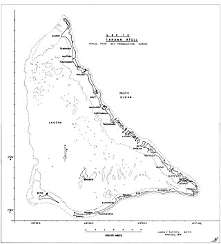
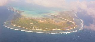
Tarawa is an atoll and the capital of the Republic of Kiribati, in the Micronesia region of the central Pacific Ocean. It comprises North Tarawa, which has 6,629 inhabitants and much in common with other more remote islands of the Gilbert group, and South Tarawa, which has 56,388 inhabitants as of 2015, half of the country's total population. The atoll was the site of the Battle of Tarawa during World War II.

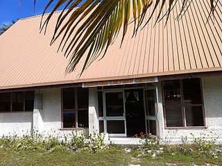
Bairiki is a town located in South Tarawa, Kiribati. It is crucial to the country's political and administrative structure as several governmental organizations and diplomatic missions are situated there.

South Tarawa is the capital and hub of the Republic of Kiribati and home to more than half of Kiribati's population. The South Tarawa population centre consists of all the small islets from Betio in the west to Bonriki and Tanaea in the north-east, connected by the South Tarawa main road, with a population of 63,439 as of 2020.

The House of Assembly is the sole chamber of the Parliament of Kiribati. Since 2016, it has 45 members, 44 elected for a four-year term in 23 single-seat and multi-seat constituencies and 1 non-elected delegate from the Banaban community on Rabi Island in Fiji. From 1979 to 2016, the Attorney general was an ex officio member of the legislature, until a change of the constitution modified this provision.

Nonouti is an atoll and district of Kiribati. The atoll is located in the Southern Gilbert Islands, 38 km north of Tabiteuea, and 250 km south of Tarawa. The atoll is the third largest in the Gilbert Islands and is the island where the Roman Catholic religion was first established in Kiribati, in 1888.

Abaokoro is a settlement in Kiribati. It is located about nine nautical miles from Tarawa. It is located in the Tarawa Atoll.
Bikenibeu is a settlement in Kiribati. It is located close to the southeastern corner of the Tarawa atoll, part of the island country of Kiribati. It is part of a nearly continuous chain of settlements along the islands of South Tarawa, which are now linked by causeways. The low-lying atoll is vulnerable to sea level rise. Rapid population growth has caused some environmental problems. Kiribati's main government high school, King George V and Elaine Bernachi School, is located in Bikenibeu, as well as the Ministries of Environment and Education.
Education in Kiribati is free and compulsory from age 6 to 14, which includes primary school through grade six, and Junior Secondary School for three additional grade levels. In 1998, the gross primary enrollment rate was 84.4 percent, and net primary enrollment rate was 70.7 percent. School quality and access to education are better in urban areas; schools in small communities on isolated islands are expensive to maintain. Mission schools are slowly being absorbed into the government primary school system.
Biketawa is one of the twenty-four small islets which comprise the atoll of Tarawa in the Republic of Kiribati. The capital of Kiribati, South Tarawa, is located on Tarawa.

The Catholic Church in Kiribati is part of the worldwide Catholic Church, which, inspired by the life, death and teachings of Jesus Christ, and under the spiritual leadership of the Pope and Roman curia in the Vatican City is the largest Christian church in the world. Koru Tito is Bishop of Tarawa and Nauru, with see in Kiribati.
Bonriki is a settlement on Tarawa atoll, Kiribati, near Temwaiku and is part of the municipality of South Tarawa. It is in the south-east of South Tarawa. Bonriki International Airport, one of two international airports in Kiribati, is located here. One of the first roads linking islands together in Tarawa connects Bonriki to Bikenibeu.
Buota is an islet and a settlement on the island of Tarawa, Kiribati. There are 1,756 inhabitants (2015). The islet is the southernmost part of North Tarawa even if there is a bridge connecting it to Bonriki and South Tarawa.
Taborio is a settlement on the island of Tarawa, Kiribati, where the Immaculate Heart College, a Catholic school, is situated.

The Sacred Heart Cathedral is a religious building of the Catholic church that is located in South Tarawa on the atoll of Tarawa part of the island nation of Kiribati in Oceania.
King George V School (KGV) was a government high school for boys in the Gilbert Islands, within the British colony Gilbert and Ellice Islands. Throughout its history it was in multiple locations in South Tarawa and Abemama. It served as a boarding school, and trained people to be government workers and teachers.
Temwaiku is a town and settlement in South Tarawa in Kiribati. It is part of a nearly continuous chain of settlements along the islands of South Tarawa, which are linked by causeways, in the same islet of Bonriki.
Koru Tito was an I-Kiribati priest of the Roman Catholic Church who was appointed bishop of the Diocese of Tarawa and Nauru on 29 June 2020 but was not consecrated a bishop before his death.
