Bikenibeu

Last updated

Bikenibeu
Te Umanibong.jpg
Cultural Museum in Bikenibeu
Tarawa map w.jpg
Kiribati location map.svg
Red pog.svg
Bikenibeu
Pacific Ocean laea location map.svg
Red pog.svg
Bikenibeu
Coordinates: 1°22′01″N173°07′34″E / 1.367°N 173.126°E / 1.367; 173.126
CountryFlag of Kiribati.svg  Kiribati
Island group Gilbert Islands
Atoll Tarawa
Locality South Tarawa
Area
  Total1.81 km2 (0.70 sq mi)
Population
 (2010) [1]
  Total6,568
  Density3,600/km2 (9,400/sq mi)

Bikenibeu is a settlement in Kiribati. It is located close to the southeastern corner of the Tarawa atoll, part of the island country of Kiribati. It is part of a nearly continuous chain of settlements along the islands of South Tarawa, which are now linked by causeways. The low-lying atoll is vulnerable to sea level rise. Rapid population growth has caused some environmental problems. Kiribati's main government high school, King George V and Elaine Bernachi School, is located in Bikenibeu, [2] as well as the Ministries of Environment and Education.

Contents

Location

Bikenibeu is one of the three main urban centres in South Tarawa, the others being Betio and Teaoraereke. [2] Starting in 1963, causeways began to be built between the islands of the atoll to make communications easier. [3] The causeways connected Bairiki to Bikenibeu by 1963, and extended from Bikenibeu to Bonriki by 1964, when flights began from the new airport to Fiji. [4]

Bikenibeu island lies between the Tarawa Lagoon to the north, with a maximum depth of 25 metres (82 ft), and the Pacific Ocean to the south, with a depth of up to 4,000 metres (13,000 ft). [5]

The island has been built from sediments from the lagoon. [6]

The process of soil accumulation is driven by the dominant easterly trade winds, and can be reversed during extended periods of westerly winds during El Niño–Southern Oscillations. [7]

Bikenibeu is an average of 3.25 metres (10.7 ft) above sea level on the ocean side, and 2.38 metres (7 ft 10 in) at the lagoon side. [8] Tidal flats on the ocean side extend for 160 metres (520 ft). [5]

ACLR (Accelerated Sea-Level Rise) is a serious concern. In a scenario where a sea level rise of .5 metres (1 ft 8 in) occurs, 71% of Bikenibeu would be flooded by a spring high tide. With a rise of .95 metres (3 ft 1 in) the tide would flood the entire island. [7]

As of 2000, the lagoon away from the shore was still relatively free of human contaminants. [9] However, the causeways linking the islands of South Tarawa have contributed to increasing pollution in the lagoon. [10]

The coral reefs provide natural protection to the coastline, important if sea levels rise. [7] A 2000 report noted large numbers of dead corals on the reef flats on the ocean side, apparently due to past discharges of sewerage. The causeways and land reclamation have also affected the reef environment. [11]

Other environmental problems caused by the growing population include over-fishing and reduction of useful plants and trees such as coconuts. [10]

Population

As of 1996, South Tarawa was almost continuously settled from the Bonriki International Airport through Bikenibeu to Bairiki in the west. [2]

In 1996, there were 4,885 people living on Bikenibeu island, with an area of 1.81 square kilometres (0.70 sq mi). [12]

As of 2005, the population was 6,170, living in 831 households. [13]

By 2010, the population had grown to 6,568. [1]

Migration and population pressure has caused a number of families to build homes on vacant land, becoming squatters. [14]

Facilities

In 1953, the decision was made to build facilities for the medical and education departments at Bikenibeu. [3]

A permanent hospital was built at Bikenibeu in 1956. [15]

Several ministries are based in the settlement.[ citation needed ] These include the Ministry of Education, [16] and the Ministry of Environment, Lands and Agricultural Development. The Ministry of Health and the nursing school are now housed in a new hospital in the neighbouring village of Nawerewere that was built in 1991 with aid from Japan. [10] This is the country's main hospital for medicine, surgery and anaesthetics, paediatrics, obstetrics and gynaecology, and psychiatry, and includes a laboratory, pharmacy and x-ray facility. [17] The general hospital has 160 beds. There is also a dental clinic. [18]

A power plant in Bikenibeu provides a mains electrical service; [2] the hospital at Nawerewere is supplied by the grid, and also had back-up power for essential services.[ citation needed ]

After a cholera epidemic in 1977 a reticulated sewerage system was installed, using sea water as the conveyance medium. [lower-alpha 1] [10]

The King George V school was moved from temporary buildings at Abemama and established in a new building in Bikenibeu in June 1953. [20]

The Elaine Bernacchi Secondary School for girls opened 1959, named after the wife of the Resident Commissioner at the time, Michael Bernacchi. [21]

Also in the late 1950s, the Tarawa Teachers' College began to operate in Bikenibeu.

The two Bikenibeu secondary schools began to be integrated from 1965. [3] They are now a single co-educational school run by the government – KGV/EBS. [10]

Education in Kiribati is compulsory and free from age six to fourteen (year 9).

Church missions provide secondary education for year 10–13 pupils who fail to be admitted to KGV/EBS. [22]

Preachers of the Baháʼí Faith came to Kiribati in 1954, setting up their first centre in Abaiang. The Baháʼí Faith was recognised as a legal religion in 1955. [23] The Baháʼís moved to Bikenibeu in 1957, where they established a centre and housing for resident or travelling teachers. In 1967, the Kiribati Baháʼís set up an independent National Spiritual Assembly with headquarters in Bikenibeu. The Baháʼí Faith in Kiribati claimed 4,000 members in 1985. [24]

There is also a Catholic church dedicated to Saint Peter, and a number of smaller Catholic and Protestant churches and maneaba .

Located on the lagoon side of the island, Otintaai is the only hotel in Bikenibeu with modern amenities. [25]

Te Umanibong, a cultural centre that features local artefacts, is open weekdays. [26]

Bikenibeu Post Office opened on 1 July 1958. [27]

Notable people

See also

Related Research Articles

<span class="mw-page-title-main">Politics of Kiribati</span> Political system of Kiribati

Politics of Kiribati takes place in a framework of a parliamentary representative democratic republic, whereby the Beretitenti, President of Kiribati, is both the head of state and head of government, and of a multi-party system. Executive power is exercised by the government, Beretitenti, and his cabinet, all MPs. Legislative power is exercised by the House of Assembly. The Judiciary of Kiribati is independent of the executive and the legislature. The Constitution of Kiribati, promulgated at independence on 12 July 1979, establishes the Republic of Kiribati as a sovereign democratic republic and guarantees the fundamental rights of its citizens and residents.

<span class="mw-page-title-main">Gilbert and Ellice Islands</span> 1892–1976 British colony in the Pacific

The Gilbert and Ellice Islands in the Pacific Ocean were part of the British Empire from 1892 to 1976. They were a protectorate from 1892 to 12 January 1916, and then a colony until 1 January 1976. The history of the colony was mainly characterized by phosphate mining on Ocean Island. In October 1975, these islands were divided by force of law into two separate colonies, and they became independent nations shortly thereafter: the Ellice Islands became Tuvalu in 1978, and the Gilbert Islands became part of Kiribati in 1979.

<span class="mw-page-title-main">Abaiang</span> Atoll of Kiribati

Abaiang, also known as Apaiang, Apia, and in the past, Charlotte Island, in the Northern Gilbert Islands, is a coral atoll of Kiribati, located in the west-central Pacific Ocean. Abaiang was the island of the first missionary to arrive in the Gilberts, Hiram Bingham II. Abaiang has a population of 5,872.

<span class="mw-page-title-main">Butaritari</span> Atoll in the Pacific Ocean island nation of Kiribati

Butaritari is an atoll in the Pacific Ocean island nation of Kiribati. The atoll is roughly four-sided. The south and southeast portion of the atoll comprises a nearly continuous islet. The atoll reef is continuous but almost without islets along the north side. Bikati and Bikatieta islets occupy a corner of the reef at the extreme northwest tip of the atoll. Small islets are found on reef sections between channels on the west side. The lagoon of Butaritari is deep and can accommodate large ships, though the entrance passages are relatively narrow. It is the most fertile of the Gilbert Islands, with relatively good soils and high rainfall. Butaritari atoll has a land area of 13.49 km2 (5.21 sq mi) and a population of 3,224 as of 2015. During World War II, Butaritari was known by United States Armed Forces as Makin Atoll, and was the site of the Battle of Makin. Locally, Makin is the name of a separate but closest atoll, 3 kilometres to the northeast of Butaritari, but close enough to be seen. These two atolls share a dialect of the Gilbertese language.

<span class="mw-page-title-main">Tarawa</span> Atoll in the South Pacific

Tarawa is an atoll and the capital of the Republic of Kiribati, in the Micronesia region of the central Pacific Ocean. It comprises North Tarawa, which has 6,629 inhabitants and much in common with other more remote islands of the Gilberts group, and South Tarawa, which has 56,388 inhabitants as of 2015, half of the country's total population. The atoll was the site of the Battle of Tarawa during World War II.

<span class="mw-page-title-main">Bairiki</span> Town in Gilbert Islands, Kiribati

The important town of Bairiki, which is located in South Tarawa, Kiribati, is crucial to the country's political and administrative structure. This region houses important governmental organizations and diplomatic missions, making it the center of national politics and international affairs.

<span class="mw-page-title-main">South Tarawa</span> Island of the Republic of Kiribati

South Tarawa is the capital and hub of the Republic of Kiribati and home to more than half of Kiribati's population. The South Tarawa population centre consists of all the small islets from Betio in the west to Bonriki and Tanaea in the north-east, connected by the South Tarawa main road, with a population of 63,439 as of 2020.

<span class="mw-page-title-main">Betio</span> Town in Gilbert Islands, Kiribati

Betio is the largest township of Kiribati's capital city, South Tarawa, and the country's main port. The settlement is located on a separate islet at the extreme southwest of the atoll.

<span class="mw-page-title-main">Abemama</span> Atoll of Kiribati

Abemama (Apamama) is an atoll, one of the Gilberts group in Kiribati, and is located 152 kilometres southeast of Tarawa and just north of the Equator. Abemama has an area of 27.37 square kilometres and a population of 3,299 as of 2015. The islets surround a deep lagoon. The eastern part of the atoll of Abemama is linked together by causeways making automobile traffic possible between the different islets. The outlying islands of Abatiku and Biike are situated on the southwestern side of the atoll.

<span class="mw-page-title-main">Nabetari</span>

Nabetari is a Gilbertese native who impressed several senior Allied officers with his successful attempt on or about 4 April 1944 to escape from the Japanese occupation of the Gilbert Islands during the Second World War.

<span class="mw-page-title-main">Beru (atoll)</span>

Beru is an atoll in the Southern Gilbert Islands in the Pacific Ocean, part of the Republic of Kiribati. Beru was previously known as Eliza, Francis Island, Maria, Peroat, Peru Island or Sunday. It's part of a larger reef with the Nuka Lagoon at its center, and the nearest island is Nikunau. The Tabiang Lagoon is present in the north. Beru is home to 2,051 inhabitants. Due to sea surges, the atoll is experiencing coastal erosion along with damages to seawalls.

<span class="mw-page-title-main">Kuria (atoll)</span> Atoll in Central Gilbert Islands, Kiribati

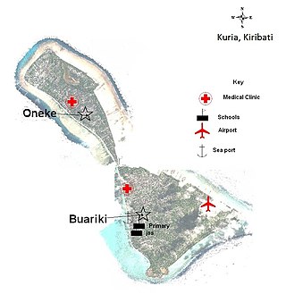
Kuria is an atoll, formed by a pair of islets, in the Central Gilbert Islands in Kiribati, northwest of Aranuka. The two islets, Buariki and Oneeke, are separated by a 20 metre wide channel on a shallow water platform, which is crossed by a bridge of the connecting road. The islands are surrounded by fringing reef which is broadest on the eastern side of Kuria. The population of Kuria was 1,046 in 2015.

<span class="mw-page-title-main">Marakei</span>

Marakei is a small atoll in the North Gilbert Islands. It consists of a central lagoon with numerous deep basins, surrounded by two large islands separated by two narrow channels. The atoll covers approximately 40 square kilometres (15 sq mi).

<span class="mw-page-title-main">Law enforcement in Kiribati</span>

The only State disciplined forces in Kiribati are a unified national police force, with prison and quarantine powers, and the coast guard. Defense assistance is provided by Australia and New Zealand. The police force does not report to any ministers but rather directly to the President of Kiribati.

<span class="mw-page-title-main">Makin (atoll)</span>

Makin is the name of an atoll, chain of islands, located in the Pacific Ocean island nation of Kiribati. Makin is the northernmost of the Gilbert Islands, with a population of 1,990.

Education in Kiribati is free and compulsory from age 6 to 14, which includes primary school through grade six, and Junior Secondary School for three additional grade levels. In 1998, the gross primary enrollment rate was 84.4 percent, and net primary enrollment rate was 70.7 percent. School quality and access to education are better in urban areas; schools in small communities on isolated islands are expensive to maintain. Mission schools are slowly being absorbed into the government primary school system.

King George V and Elaine Bernacchi School (KGV/EBS) is a government senior high school of Kiribati, located in Bikenibeu, South Tarawa. As of 1993 it has almost 600 students. In 1993 it had a competitive admissions process as there was not enough space for every high school student in Kiribati; the remainder had to enroll in Christian high schools. Since then the Kiribati government had established two additional government high schools.

King George V School (KGV) was a government high school for boys in the Gilbert Islands, within the British colony Gilbert and Ellice Islands. Throughout its history it was in multiple locations in South Tarawa and Abemama. It served as a boarding school, and trained people to be government workers and teachers.

<span class="mw-page-title-main">Roniti Teiwaki</span>

Roniti Teiwaki is an I-Kiribati politician.

<span class="mw-page-title-main">Coral reefs of Kiribati</span> Pacific Ocean Island chain

The Coral reefs of Kiribati consists of 32 atolls and one raised coral island, Banaba, which is an isolated island between Nauru and the Gilbert Islands. The islands of Kiribati are dispersed over 3.5 million km2 (1.4 million sq mi) of the Pacific Ocean and straddle the equator and the 180th meridian, extending into the eastern and western hemispheres, as well as the northern and southern hemispheres. 21 of the 33 islands are inhabited. The groups of islands of Kiribati are:

References

Notes

  1. Use of seawater to transport sewage can be a viable and cost-effective option in island communities such as Tarawa where potable water is in short supply – and even in larger cities such as Hong Kong. [19]

Citations

  1. 1 2 Kiribati Census 2010.
  2. 1 2 3 4 "6. South Tarawa" (PDF). Office of Te Beretitent – Republic of Kiribati Island Report Series. 2012. Archived from the original (PDF) on 23 September 2015. Retrieved 28 April 2015.
  3. 1 2 3 Talu & 24 others 1984, p. 99.
  4. MacDonald 2001, p. 177.
  5. 1 2 Martin 2000, p. 152.
  6. Schofield 1977, p. 533.
  7. 1 2 3 Chaoxiong 2001, p. 6.
  8. Chaoxiong 2001, p. 5.
  9. Martin 2000, p. 160.
  10. 1 2 3 4 5 Trease 1993, p. 127.
  11. Hopley 2011, p. 64.
  12. Martin 2000, p. 115-116.
  13. Kiribati 2005 Census, p. 2.
  14. Mason & Hereniko 1987, p. 208.
  15. Talu & 24 others 1984, p. 100.
  16. "About Us." Ministry of Education (Kiribati). Retrieved on 6 July 2018.
  17. Trease 1993, p. 251.
  18. Hinz & Howard 2006, p. 348.
  19. Wells & Rose 2006, p. 1.
  20. MacDonald 2001, p. 169.
  21. Trease 1993, p. 135.
  22. Trease 1993, p. 242.
  23. Finau, Ieuti & Langi 1992, p. 101.
  24. Finau, Ieuti & Langi 1992, p. 102.
  25. Thompson 2002, p. 19.
  26. Hunt 2000, p. 239.
  27. Premier Postal History. "Post Office List". Premier Postal Auctions. Retrieved 5 July 2013.

Sources