
Algeria comprises 2,381,740 square kilometres (919,590 sq mi) of land, more than 80% of which is desert, in North Africa, between Morocco and Tunisia. It is the largest country in Africa. Its Arabic name, Al Jazair, is believed to derive from the rocky islands along the coastline of the Mediterranean Sea. The northern portion, an area of mountains, valleys, and plateaus between the Mediterranean and the Sahara Desert, forms an integral part of the section of North Africa known as the Maghreb. This area includes Morocco, Tunisia, and the northwestern portion of Libya known historically as Tripolitania.

Tunisia is a country in Northern Africa, bordering the Mediterranean Sea, having a western border with Algeria (965 km) and south-eastern border with Libya (459 km) where the width of land tapers to the south-west into the Sahara. The country has north, east and complex east-to-north coasts including the curved Gulf of Gabès, which forms the western part of Africa's Gulf of Sidra. Most of this greater gulf forms the main coast of Libya including the city of Sirte which shares its root name. The country's geographic coordinates are 34°00′N9°00′E. Tunisia occupies an area of 163,610 square kilometres, of which 8,250 are water. The principal and reliable rivers rise in the north of the country with a few notable exceptions from north-east Algeria and flow through the northern plain where sufficient rainfall supports diverse plant cover and irrigated agriculture.

The Great Appalachian Valley, also called The Great Valley or Great Valley Region, is one of the major landform features of eastern North America. It is a gigantic trough, including a chain of valley lowlands, and the central feature of the Appalachian Mountains system. The trough stretches about 1,200 miles (1,900 km) from Quebec in the north to Alabama in the south and has been an important north–south route of travel since prehistoric times.
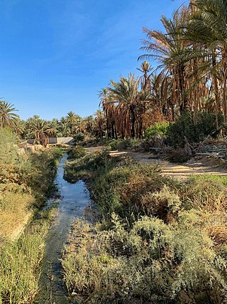
el-Djerid, also al-Jarīd, or more precisely the South Western Tunisia Region is a semi-desert natural region comprising three southern Tunisian Governorates, Gafsa, Kebili and Tozeur with adjacent parts of Algeria and Libya.

The Tunisian campaign was a series of battles that took place in Tunisia during the North African campaign of the Second World War, between Axis and Allied forces from 17 November 1942 to 13 May 1943. The Allies consisted of British Imperial Forces, including a Greek contingent, with American and French corps. The battle opened with initial success by the German and Italian forces but the massive supply interdiction efforts led to the decisive defeat of the Axis. Over 250,000 German and Italian troops were taken as prisoners of war, including most of the Afrika Korps.

The Battle of El Guettar was a battle that took place during the Tunisia Campaign of World War II, fought between elements of the Army Group Africa under General Hans-Jürgen von Arnim, along with Italian First Army under General Giovanni Messe, and U.S. II Corps under Lieutenant General George Patton in south-central Tunisia. It was the first battle in which U.S. forces were able to defeat the experienced German tank units, but the followup to the battle was inconclusive.
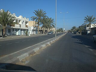
Matmata is a small Berber speaking town in southern Tunisia. Some of the local Berber residents live in traditional underground "troglodyte" structures. In 2004 it had a population of 2,116.

The Mareth Line was a system of fortifications built by France in southern Tunisia in the late 1930s. The line was intended to protect Tunisia against an Italian invasion from its colony in Libya. The line occupied a point where the routes into Tunisia from the south converged, leading toward Mareth, with the Mediterranean Sea to the east and mountains and a sand sea to the west.

The Battle of the Mareth Line or the Battle of Mareth was an attack in the Second World War by the British Eighth Army in Tunisia, against the Mareth Line held by the Italo-German 1st Army. It was the first big operation by the Eighth Army since the Second Battle of El Alamein 4+1⁄2 months previously. On 19 March 1943, Operation Pugilist, the first British attack, established a bridgehead but a break-out attempt was defeated by Axis counter-attacks. Pugilist established an alternative route of attack and Operation Supercharge II, an outflanking manoeuvre via the Tebaga Gap was planned. Montgomery reinforced the flanking attack, which from 26 to 31 March, forced the 1st Army to retreat to Wadi Akarit, another 40 mi (64 km) back in Tunisia.

The Battle of Medenine was an Axis spoiling attack at Medenine in Tunisia on 6 March 1943. The operation was intended to delay an attack by the British Eighth Army on the Mareth Line. The British had been forewarned by Ultra decrypts of German wireless communications and rushed reinforcements from Tripoli and Benghazi before the Axis attack, which was a costly failure. General Erwin Rommel, the commander of Army Group Africa (Heeresgruppe Afrika), could not afford to lose forces needed for the defence of the Mareth Line and the effort was abandoned at dusk that day.

Tozeur is the westernmost of the 24 governorates (provinces) of Tunisia and as such bordering Algeria. It covers an area of 4,719 km2 and has a population of 107,912 making it the least populated province. The capital is Tozeur.
The 69th Infantry Brigade was an infantry brigade of the British Army in the Second World War. It was a second-line Territorial Army formation, and fought in the Battle of France with the 23rd (Northumbrian) Division. The brigade was later part of the 50th (Northumbrian) Infantry Division. It went on to fight in the North African campaign, the Allied invasion of Sicily, the Normandy landings and the North West Europe campaign.

The Great Indian Warpath (GIW)—also known as the Great Indian War and Trading Path, or the Seneca Trail—was that part of the network of trails in eastern North America developed and used by Native Americans which ran through the Great Appalachian Valley. The system of footpaths extended from what is now upper New York to deep within Alabama. Various Native peoples traded and made war along the trails, including the Catawba, numerous Algonquian tribes, the Cherokee, and the Iroquois Confederacy. The British traders' name for the route was derived from combining its name among the northeastern Algonquian tribes, Mishimayagat or "Great Trail", with that of the Shawnee and Delaware, Athawominee or "Path where they go armed".

Interstate 20 in Texas (I-20) is a major east–west Interstate Highway in the Southern United States, running east from a junction with I-10 east of Kent, Texas, through the Dallas–Fort Worth metroplex to the Louisiana state line near Waskom, Texas. The original distance of I-20 was 647 miles (1,041 km) from I-10 to the Louisiana state line, reduced to the current distance of 636 miles (1,024 km) with the rerouting of I-20 in the 1980s and 1990s. I-20 is known as the Ronald Reagan Memorial Highway within the Dallas–Fort Worth metroplex.
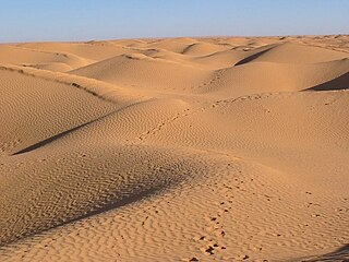
The Grand Erg Oriental is a large erg or "field of sand dunes" in the Sahara Desert. Situated for the most part in Saharan lowlands of northeast Algeria, the Grand Erg Oriental covers an area some 600 km wide by 200 km north to south. The erg's northeastern edge spills over into neighbouring Tunisia.

The Tunisian salt lakes are a series of lakes in central Tunisia, lying south of the Atlas Mountains at the northern edge of the Sahara. The lakes include, from east to west, the Chott el Fedjedj, Chott el Djerid, and Chott el Gharsa.
El Hamma is an oasis town located in the Gabès Governorate, 30 kilometers west of Gabès, Tunisia and near the eastern end of Chott el Fejej. Its population in 2014 was 73,512.
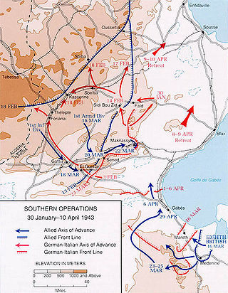
The Battle of Wadi Akarit was an Allied attack from 6 to 7 April 1943, to dislodge Axis forces from positions along the Wadi Akarit in Tunisia during the Tunisia Campaign of the Second World War. The Gabès Gap, north of the towns of Gabès and El Hamma, is a passage between the sea and impassable salt marshes. The 51st (Highland) Infantry Division breached the defences and held a bridgehead, allowing the passage of their main force to roll up the Axis defences. After several determined counter-attacks, the Axis forces withdrew and the Eighth Army, under General Bernard Montgomery, pursued toward Tunis, until reaching Axis defensive positions at Enfidaville.

The topography of Pakistan is divided into seven geographic areas: the northern highlands, the Indus River plain, the desert areas, the Pothohar Plateau, Balochistan Plateau, Salt Range, and the Sistan Basin. All the rivers of Pakistan, i.e. Sindh, Ravi River, Chenab River, Jhelum River, and Sutlej River, originate from the Himalayas mountain range. Some geographers designate Plateau as to the west of the imaginary southwest line; and the Indus Plain lies to the east of that line.
Jebel Dahar is a low sandstone mountain chain of the Médenine Governorate of Tunisia.
