Related Research Articles
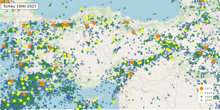
The geology of Turkey is the product of a wide variety of tectonic processes that have shaped Anatolia over millions of years, a process which continues today as evidenced by frequent earthquakes and occasional volcanic eruptions.
The Queen Charlotte Triple Junction is a geologic triple junction where three tectonic plates meet: the Pacific Plate, the North American Plate, and the Explorer Plate. The three plate boundaries which intersect here are the Queen Charlotte Fault, the northern Cascadia subduction zone, and the Explorer Ridge. The Queen Charlotte triple junction is currently positioned adjacent to the Queen Charlotte Sound near the Dellwood Knolls off the coast of Vancouver Island. 10 Ma to 1.5 Ma prior to the triple junction's current location, it was located southwest of Vancouver Island The movements of the triple junction have been characterized by two major shifts in the Pacific-North American Tertiary plate tectonic record. First, at approximately 40 Ma the relative plate motions switched from orthogonal convergence to right-lateral strike slip. The variance in location of the triple junction may have also been related to the formation of an independent basin block. This formation could have been produced by fore-arc bending of the Pacific Plate, due to oblique underthrusting prior to 1 Ma which produced stresses sufficient to break the Pacific Plate and isolate the block. Transpression of 15–30 mm/yr since 5 Ma has been taking place, as well as varying amounts of both transpression and transtension occurring before then. To the northwest of the triple junction the Pacific plate currently has 15 degrees of oblique convergence, passing under the North American plate along the Queen Charlotte transform fault zone. The Explorer plate is a small chunk of the Juan de Fuca plate that broke away from the Juan de Fuca Plate about 3.5 Ma and has moved much slower with respect to North America.

The Longmenshan Fault is a thrust fault which runs along the base of the Longmen Mountains in Sichuan province in southwestern China. The strike of the fault plane is approximately NE. Motion on this fault is responsible for the uplift of the mountains relative to the lowlands of the Sichuan Basin to the east. Representing the eastern boundary of the Qinghai-Tibet Plateau, it is a border formation between the Bayan Kola block in the Plateau and the South China block in the Eurasian Plate. The 2008 Wenchuan, 2013 Lushan and 2022 Ya'an earthquakes occurred along this fault.

An earthquake occurred in China on 14 November 2001 at 09:26 UTC, with an epicenter near Kokoxili, close to the border between Qinghai and Xinjiang in a remote mountainous region. With a magnitude of 7.8 Mw, it was the most powerful earthquake in China for 5 decades. No casualties were reported, presumably due to the very low population density and the lack of high-rise buildings. This earthquake was associated with the longest surface rupture ever recorded on land, ~450 km.
A 6.2 magnitude earthquake occurred in Afghanistan on October 22, 2009 at 19:51:27 UTC. The maximum Mercalli intensity was V (Moderate) at Fayzabad, Badakhshan.

The 1927 Gulang earthquake occurred at 6:32 a.m. on 22 May. This 7.6 magnitude event had an epicenter near Gulang, Gansu in the Republic of China. There were 40,912 deaths. It was felt up to 700 km (435 mi) away.

Intraplate deformation is the folding, breaking, or flow of the Earth's crust within plates instead of at their margins. This process usually occurs in areas with especially weak crust and upper mantle, such as the Tibetan Plateau. Intraplate deformation brings another aspect to plate tectonic theory.
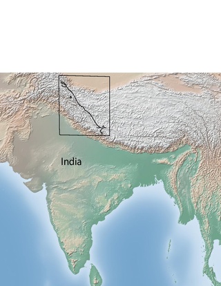
The Karakoram fault is an oblique-slip fault system in the Himalayan region across India and Asia. The slip along the fault accommodates radial expansion of the Himalayan arc, northward indentation of the Pamir Mountains, and eastward lateral extrusion of the Tibetan plateau. Current plate motions suggest that the convergence between the Indian Plate and the Eurasian Plate is around 44±5 mm per year in the western Himalaya-Pamir region and approximately 50±2 mm per year in the eastern Himalayan region.
The Haiyuan Fault is a major active intracontinental strike-slip (sinistral) fault in Central Asia.
The 1973 Luhuo earthquake struck near the town of Zhaggo in Garzê Tibetan Autonomous Prefecture of Sichuan Province, China on February 6, 1973, with a magnitude of 7.6 Ms. The earthquake had a maximum intensity of X (Extreme) on the Modified Mercalli intensity scale. It resulted in between 2,175 and 2,204 deaths and a further 2,743 injuries. Serious and widespread destruction occurred in Luhuo County.

On May 21, 2021, a 6.1 magnitude earthquake struck the Dali City, Yunnan, China, at a depth of 10.0 km. Three people died during the quake, while another 32 were injured. The earthquake was referred by the Chinese media as the 5.21 earthquake or 2021 Yangbi earthquake.
The 2021 Maduo earthquake, also known as the 5.22 earthquake struck Madoi County in Qinghai Province, China on 22 May at 02:04 local time. The earthquake had a moment magnitude and surface-wave magnitude of 7.4. Highway bridges, roads and walls collapsed as a result of the earthquake. According to an anonymous source, at least 20 people were killed, 300 were injured, and 13 were missing. Officials stated that there were no deaths but 19 people sustained minor injuries. It was the strongest in China since 2008. It was assigned a maximum intensity of X in Machali, Maduo County on the China seismic intensity scale and Modified Mercalli intensity scale. This earthquake was preceded by another unrelated earthquake that occurred 5 hours earlier in Yunnan.
The 1889 Chilik earthquake occurred on July 11 on the Gregorian calendar, or June 30 on the Julian calendar at 15:14 local time in the Tien Shan mountains. The earthquake measured an estimated Mw 7.9–8.0 on the moment magnitude scale and was assigned a maximum intensity of X (Devastating) on the MSK 64 and Rossi-Forel scales. Over 92 people across Kazakhstan, Kyrgyzstan and China were killed.
The 2021 Luxian earthquake was a damaging seismic event occurring in the early hours of September 16 at 04:33 China Standard Time. The surface wave magnitude (Ms ) 6.0 or moment magnitude (Mw ) 5.4 earthquake struck at a shallow depth of 7.5 km and severe shaking in an area of 4,000 square kilometers was assigned a maximum intensity of VIII on the China seismic intensity scale. Three people were killed and 146 injured when the earthquake struck Lu County, Luzhou, Sichuan Province. At least 36,800 buildings were affected, 7,800 of them seriously damaged or completely destroyed, causing about a quarter of a billion dollars worth of damage.
An earthquake occurred on June 19, 1718, in Tongwei County, Gansu Province, Qing dynasty, present-day China. The estimated surface wave magnitude (Ms ) 7.5 earthquake was designated a maximum Modified Mercalli intensity of X (Extreme), causing tremendous damage and killing 73,000 people.
The 1992 Kohat earthquake struck Khyber Pakhtunkhwa Province in Pakistan on May 20. The Mw 6.3 earthquake inflicted significant damage in the nearby city Kohat. An estimated 36 people died and 100 were injured in the Peshawar and Kohat districts. Four-hundred (400) homes were wiped out, affecting 2,100 residents in the region.
The 1850 Xichang earthquake rocked Sichuan Province of Qing China on September 12. The earthquake which caused major damage in Xichang county had an estimated moment magnitude of 7.6–7.9 Mw and a surface wave magnitude of 7.5–7.7 Ms . An estimated 20,650 people died.
The 1654 Tianshui earthquake occurred on July 21 in Tianshui, Gansu Province, Ming dynasty sometime between 21:00 and 23:00 local time. The event had an estimated moment magnitude of 7.0 and was assigned a maximum intensity of XI on the China seismic intensity scale. Resulting in extreme damage and affecting at least four provinces, the quake killed approximately 30,000 people.
The 1923 Renda earthquake occurred on March 24 at 20:40 local time between the counties of Daofu and Luhuo in Sichuan, China. The estimated Ms 7.3 earthquake was assigned a maximum modified Mercalli intensity scale rating of X (Extreme). Severe damage occurred in Sichuan, killing an estimated 4,800 people.
The 1955 Zheduotang earthquake, also known as the Kangding earthquake occurred on April 14 at 09:29:02 local time near the city of Kangding in the Garzê Tibetan Autonomous Prefecture, Sichuan. The earthquake had a moment magnitude of 7.0 and a surface wave magnitude of 7.1 and struck at a depth of 10 km. Severe damage occurred in Kangding with the loss of 70 lives.
References
![]() This article incorporates public domain material from Magnitude 6.9 - SOUTHERN QINGHAI, CHINA. United States Geological Survey . Retrieved 2010-07-15.
This article incorporates public domain material from Magnitude 6.9 - SOUTHERN QINGHAI, CHINA. United States Geological Survey . Retrieved 2010-07-15.