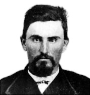
Murdo MacKenzie was twice manager of the Scots-owned Matador Land and Cattle Company, and founding president of the American Stock Growers Association, for whom he testified before congress and the Interstate Commerce Commission. His testimony led to passage of the Hepburn Act of 1906 which eased railroad fares for western shippers.

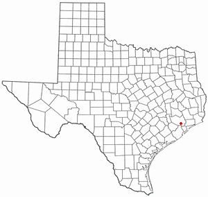
Motley County is a county located in the U.S. state of Texas. As of the 2020 census, its population was 1,063, making it the 10th-least populous county in Texas. Its county seat is Matador. The county was created in 1876 and organized in 1891. It is named for Junius William Mottley, a signer of the Texas Declaration of Independence. Mottley's name is spelled incorrectly because the bill establishing the county misspelled his name. Motley County was one of 30 prohibition, or entirely dry, counties in Texas, but is now a wet county.

Crosby County is a county located in the U.S. state of Texas. As of the 2020 census, its population was 5,133. The county seat is Crosbyton. The county was founded in 1876 and later organized in 1886. Both the county and its seat are named for Stephen Crosby, a land commissioner in Texas.
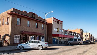
Matador is a town in and the county seat of Motley County, Texas, United States. Its population was 607 at the 2010 census. In 1891, it was established by and named for the Matador Ranch. It is located 95 miles (153 km) east of Lubbock, Texas.
Charles Goodnight, also known as Charlie Goodnight, was a rancher in the American West. In 1955, he was inducted into the Hall of Great Westerners of the National Cowboy & Western Heritage Museum.
La Réunion was a utopian socialist community formed in 1855 by French, Belgian, and Swiss colonists on the south bank of the Trinity River in central Dallas County, Texas, United States. The colony site is a short distance north of Interstate 30 near downtown Dallas. The founder of the community, Victor Prosper Considerant, was a French democratic socialist who directed an international movement based on Fourierism, a set of economic, political, and social beliefs advocated by French philosopher François Marie Charles Fourier. Fourierism subsequently became known as a form of utopian socialism.
The Allen Ranch, or Sam Allen Ranch, was one of the first and longest running ranches in the history of the state of Texas in the United States. The ranch was started a few years after the Texas Revolution in what is now southeast Houston and Pasadena. The ranch itself extended from Clear Lake to Harrisburg. The cattle range covered much of southeast Harris County and Galveston County covering many of the modern communities around Galveston Bay.
Bird's Fort was a community north of present-day Arlington, Texas (USA). In 1841, when John Neely Bryan established Dallas, he invited the settlers at Bird's Fort to come live in his proposed city.

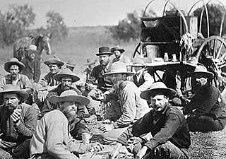
Cattle drives were a major economic activity in the 19th and early 20th century American West, particularly between 1850s and 1910s. In this period, 27 million cattle were driven from Texas to railheads in Kansas, for shipment to stockyards in St. Louis and points east, and direct to Chicago. The long distances covered, the need for periodic rests by riders and animals, and the establishment of railheads led to the development of "cow towns" across the frontier.

The Great Western Cattle Trail is the name used today for a cattle trail established during the late 19th century for moving beef stock and horses to markets in eastern and northern states. It is also known as the Western Trail, Fort Griffin Trail, Dodge City Trail, Northern Trail and Texas Trail. It ran west of and roughly parallel to the better known Chisholm Trail into Kansas, reaching an additional major railhead there for shipping beef to Chicago, or longhorns and horses continuing on further north by trail to stock open-range ranches in the Dakotas, Wyoming, Montana, and two provinces in Canada. A full-length drive from the trailhead south of Bandera, Texas took almost one hundred days to reach its destination in Kansas.

Rath City was a frontier town that existed for fewer than five years, and is now a ghost town. The town was located on the Double Mountain Fork Brazos River, 14 miles northwest of Hamlin in southern Stonewall County, Texas, United States.

Red River Station is a ghost town south of the Red River at Salt Creek in northwestern Montague County, Texas, United States.

The Pease River is a river in Texas, United States. It is a tributary of the Red River that runs in an easterly direction through West Texas. It was discovered and mapped for the first time in 1856 by Jacob de Córdova, who found the river while surveying for the Galveston, Houston and Henderson Railroad Company; it was named after Texas Governor Elisha M. Pease. In December 1860, the Texas Rangers recaptured Cynthia Ann Parker and her daughter from the Comanche Indians at an engagement along the river.

Stiles is a ghost town in Reagan County, Texas, United States, about 18 mi (29 km) north of Big Lake. As the only town in the area when Reagan County was established in 1903, Stiles was made the county seat. Bypassed by the railroad and eclipsed when oil was discovered near Big Lake, Stiles was replaced with Big Lake as the county seat in 1925.

Clairemont is a ghost town in and the former county seat of Kent County, Texas, United States. It is at the intersection of U.S. Route 380 and Texas State Highway 208, 14 mi (23 km) southwest of Jayton and 43 mi (69 km) east of Post. Clairemont lies near the center of Kent County, and the estimated population as of the 2000 census was 15.
Preston, also known as Preston Bend, is an unincorporated community and census-designated place located on the Red River in Grayson County, Texas, United States. It grew in the 19th century at the intersection of several military and trade roads and was an important crossing on the Shawnee cattle trail. Preston lost prominence after the MK&T railroad bypassed the town to the east, leading to a decline in traveler and cattle drive traffic. Much of its former town site is submerged beneath the waters of Lake Texoma. Its population was 2,096 as of the 2010 census.

Estacado is a ghost town in Crosby and Lubbock Counties in the U.S. state of Texas. Located along Farm to Market Road 1527, it was established in 1879 as a Religious Society of Friends (Quaker) colony by Paris Cox and originally named Maryetta after his wife. In 1886, it became the first government seat of Crosby County. In 1936, Recorded Texas Historic Landmark number 4779 was designated to commemorate the founding of Estacado.
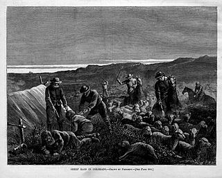
The sheep wars, or the sheep and cattle wars, were a series of armed conflicts in the Western United States fought between sheepmen and cattlemen over grazing rights. Sheep wars occurred in many western states, though they were most common in Texas, Arizona, and the border region of Wyoming and Colorado. Generally, the cattlemen saw the sheepherders as invaders who destroyed the public grazing lands, which they had to share on a first-come, first-served basis. Between 1870 and 1920, approximately 120 engagements occurred in eight states or territories. At least 54 men were killed and some 50,000 to over 100,000 sheep were slaughtered.

Whiteflat is a ghost town in Motley County, Texas, United States. The population was estimated to be 3 at the 2000 census.
Comanche Springs was an aquifer of six artesian springs geographically located between the Edwards Plateau and the Trans-Pecos regions of West Texas. The military fortification Camp Stockton was built around the springs, eventually growing become the city of Fort Stockton.


