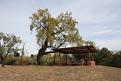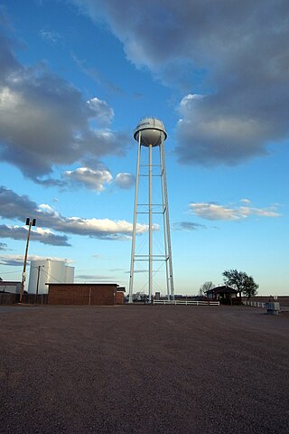
Ransom Canyon is a town in Lubbock County of West Texas, United States. The population was 1,096 at the 2010 census. It is part of the Lubbock Metropolitan Statistical Area.

The Brazos River, called the Río de los Brazos de Dios by early Spanish explorers, is the 14th-longest river in the United States at 1,280 miles (2,060 km) from its headwater source at the head of Blackwater Draw, Roosevelt County, New Mexico to its mouth at the Gulf of Mexico with a 45,000-square-mile (116,000 km2) drainage basin. Being one of Texas' largest rivers, it is sometimes used to mark the boundary between East Texas and West Texas.

The Llano Estacado, sometimes translated into English as the Staked Plains, is a region in the Southwestern United States that encompasses parts of eastern New Mexico and northwestern Texas. One of the largest mesas or tablelands on the North American continent, the elevation rises from 3,000 feet (900 m) in the southeast to over 5,000 feet (1,500 m) in the northwest, sloping almost uniformly at about 10 feet per mile (2 m/km).

West Texas is a loosely defined region in the U.S. state of Texas, generally encompassing the arid and semiarid lands west of a line drawn between the cities of Wichita Falls, Abilene, and Del Rio.

Lubbock Lake Landmark, also known as Lubbock Lake Site, is an important archeological site and natural history preserve in the city of Lubbock, Texas, United States. The protected state and federal landmark is 336 acres (136 ha). There is evidence of ancient people and extinct animals at Lubbock Lake Landmark. It has evidence of nearly 12,000 years of use by ancient cultures on the Llano Estacado. It is part of the Museum of Texas Tech University.

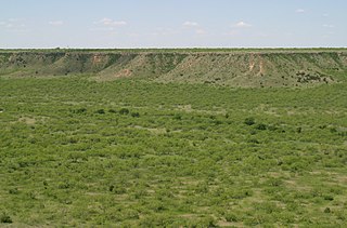
The Caprock Escarpment is a term used in West Texas and Eastern New Mexico to describe the geographical transition point between the level High Plains of the Llano Estacado and the surrounding rolling terrain.

The Buffalo Hunters' War, or the Staked Plains War, occurred in 1877. Approximately 170 Comanche warriors and their families led by Quohadi chief Black Horse or Tu-ukumah left the Indian Territory in December, 1876, for the Llano Estacado of Texas. In February, 1877, they, and their Apache allies, began attacking buffalo hunters' camps in the Red River country of the Texas Panhandle, killing or wounding several. They also stole horses from the camp of Pat Garrett.

Prairie Dog Town Fork Red River is a sandy-braided stream about 120 mi (193 km) long, formed at the confluence of Palo Duro Creek and Tierra Blanca Creek, about 1.8 mi (2.9 km) northeast of Canyon in Randall County, Texas, and flowing east-southeastward to the Red River about 1 mi (2 km) east of the 100th meridian, 8 mi (13 km) south-southwest of Hollis, Oklahoma.

Tee Pee City is a ghost town located in eastern Motley County near Matador, Texas. The ghost town is near the confluence of Tee Pee Creek and the Middle Pease River in eastern Motley County. The site, originally a Comanche campground, derived its name from the numerous teepee poles found up and down the creek by early settlers.

The Battle of Yellow House Canyon was a battle between a force of Comanches and Apaches against a group of American bison hunters that occurred on March 18, 1877, near the site of the present-day city of Lubbock, Texas. It was the final battle of the Buffalo Hunters' War, and was the last major fight involving the United States and Native Americans on the High Plains of Texas.

Double Mountains is the name of a pair of flat-topped buttes located 13 miles (21 km) southwest of Aspermont in Stonewall County, Texas. While the Handbook of Texas gives their elevation as either 2,000 ft (610 m) or 2,400 ft (732 m), United States Geological Survey maps give the elevation of the western mountain as 2,523 ft (769 m) and that of the eastern mountain as between 2,580 and 2,600 ft. Together, the mountains form part of the high ground dividing the watersheds of the Salt Fork and Double Mountain Fork Brazos River.

The Battle of Blanco Canyon was the decisive battle of Col. Ranald S. Mackenzie's initial campaign against the Comanche in West Texas, and marked the first time the Comanches had been attacked in the heart of their homeland. It was also the first time a large military force explored the heart of Comancheria. On 12 August 1871 Mackenzie and Colonel Benjamin Grierson were asked by Indian Agent Lawrie Tatum to begin an expedition against the Kotsoteka and Quahadi Comanche bands, both of whom had refused to relocate onto a reservation after the Warren Wagon Train Raid. Col. Mackenzie assembled a powerful force consisting of eight companies of the Fourth United States Cavalry, two companies of the Eleventh Infantry, and a group of twenty Tonkawa scouts.
The White River is an intermittent stream in the South Plains of Texas and a tributary of the Brazos River of the United States. It rises 8 miles (13 km) west of Floydada in southwestern Floyd County at the confluence of Callahan and Runningwater Draws. From there, it runs southeast for 62 miles (100 km) to its mouth on the Salt Fork of the Brazos River in northwestern Kent County. Besides these two headwaters, which rise near Hale Center and in Curry County, New Mexico, respectively, other tributaries include Pete, Crawfish, and Davidson Creeks. The White River drains an area of 1,690 sq mi (4,377 km2).

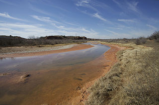
Yellow House Draw is an ephemeral watercourse about 236 km (147 mi) long, heading about 20 km (12 mi) southwest of Melrose, New Mexico, and tending generally east-southeastward across the Llano Estacado to the city of Lubbock, where it joins Blackwater Draw to form Yellow House Canyon at the head of the North Fork Double Mountain Fork Brazos River. It stretches across Roosevelt, Curry, Bailey, Cochran, Hockley, and Lubbock Counties of eastern New Mexico and West Texas, and drains an area of 9,790 km2 (3,780 sq mi).

Fieldton is an unincorporated community in Lamb County, Texas, United States. Fieldton has a post office with the ZIP code 79326.

Yellow House Canyon is about 32 km (20 mi) long, heading in Lubbock, Texas, at the junction of Blackwater Draw and Yellow House Draw, and trending generally southeastward to the edge of the Llano Estacado about 10 km (6.2 mi) east of Slaton, Texas; it forms one of three major canyons along the east side of the Llano Estacado and carries the waters of the North Fork Double Mountain Fork Brazos River.

The Double Mountain Fork Brazos River is an ephemeral, sandy-braided stream about 170 mi (280 km) long, heading on the Llano Estacado of West Texas about 11.5 mi (18.5 km) southeast of Tahoka, Texas, flowing east-northeast across the western Rolling Plains to join the Salt Fork, forming the Brazos River about 18 mi (29 km) west-northwest of Haskell, Texas.

The North Fork Double Mountain Fork Brazos River is an intermittent stream about 75 mi (121 km) long, heading at the junction of Blackwater Draw and Yellow House Draw in the city of Lubbock, flowing generally southeastward to its mouth on the Double Mountain Fork Brazos River in western Kent County. It crosses portions of Lubbock, Crosby, Garza, and Kent counties in West Texas.
The Salt Fork Brazos River is a braided, highly intermittent stream about 150 mi (240 km) long, heading along the edge of the Llano Estacado about 26 mi (42 km) east-southeast of Lubbock, Texas. From its source, it flows generally east-southeastward to join the Double Mountain Fork to form the Brazos River about 18 mi (29 km) west-northwest of Haskell, Texas. The Salt Fork stretches across portions of Crosby, Garza, Kent, and Stonewall counties of West Texas.

Hobbs is an unincorporated community in west Fisher County, Texas, United States. It is located at the intersection of Farm to Market Roads 611 and 1614, about 20 mi (32 km) east of Snyder. It lies within the physiographic region known as the Rolling Plains in the valley of the Clear Fork Brazos River.