
Stonewall County is a county located in the U.S. state of Texas. As of the 2020 census, its population was 1,245. Its county seat is Aspermont. The county was created in 1876 and organized in 1888. It is named for Stonewall Jackson, a general of the Confederate States Army.

Kent County is a county located in the U.S. state of Texas. As of the 2020 census, its population was 753, making it the sixth-least populous county in Texas. Its county seat is Jayton. The county was created in 1876 and later organized in 1892. It is named for Andrew Kent, who died at the Battle of the Alamo. Kent County is a prohibition or entirely dry county, one of four remaining in the state.

Hudspeth County is a county located in the U.S. state of Texas. As of the 2020 census, the population was 3,202. Its county seat is Sierra Blanca, and the largest community is Fort Hancock. The county is named for Claude Benton Hudspeth, a state senator and United States Representative from El Paso. It is northeast of the Mexico–U.S. border.

Stamford is a city on the border of Jones and Haskell counties in west-central Texas, United States. The population was 2,907 at the 2020 census. Henry McHarg, president of the Texas Central Railroad, named the site in 1900 for his hometown of Stamford, Connecticut. The city is home to the Texas Cowboy Reunion.

The Pease River is a river in Texas, United States. It is a tributary of the Red River that runs in an easterly direction through West Texas. It was discovered and mapped for the first time in 1856 by Jacob de Córdova, who found the river while surveying for the Galveston, Houston and Henderson Railroad Company; it was named after Texas Governor Elisha M. Pease. In December 1860, the Texas Rangers recaptured Cynthia Ann Parker, kidnapped by the Comanche Indians in 1836, and her daughter from the Comanche at an engagement along the river.

Clairemont is a ghost town in and the former county seat of Kent County, Texas, United States. It is at the intersection of U.S. Route 380 and Texas State Highway 208, 14 mi (23 km) southwest of Jayton and 43 mi (69 km) east of Post. Clairemont lies near the center of Kent County, and the estimated population as of the 2000 census was 15.
Barker is an unincorporated community in western Harris County, Texas, United States. It lies along local roads off Interstate 10 and is seventeen miles west of downtown Houston. Its elevation is 102 feet (31 m), and it is located at 29°47′4″N95°41′6″W.

Double Mountains is the name of a pair of flat-topped buttes located 13 miles (21 km) southwest of Aspermont in Stonewall County, Texas. While the Handbook of Texas gives their elevation as either 2,000 ft (610 m) or 2,400 ft (732 m), United States Geological Survey maps give the elevation of the western mountain as 2,523 ft (769 m) and that of the eastern mountain as between 2,580 and 2,600 ft. Together, the mountains form part of the high ground dividing the watersheds of the Salt Fork and Double Mountain Fork Brazos River.
The SMS Ranches are a famous group of cattle ranches located in West Texas.
Old Glory is an unincorporated community in Stonewall County, Texas, United States. The community has an estimated population of 100.
Odell is an unincorporated community in Wilbarger County, Texas, United States. According to the Handbook of Texas, the community had an estimated population of 131 in 2000.

Sagerton is an unincorporated community in Haskell County, Texas, United States.

Swenson is an unincorporated community in Stonewall County, Texas, United States. It is located immediately east of the junction of U.S. Highway 380 and FM 1646 in west-central Stonewall County. According to the Handbook of Texas, the community had an estimated population of 185 in 2000.
Alexander is an unincorporated community located in southern Erath County in Central Texas, United States. Alexander is located in the southern part of the county, along Texas State Highway 6 and Fm-914. The town was originally called: "Harper's Mill" when the Post Office was approved for operation around the 1870s. The name was changed in the 1880s, when the Texas Central line, part of the historic Katy Railroad, was built from east to west through the townsite on its way from the Waco area to Stamford, with a branch to Cross Plains from the line at De Leon. In 1907, the Stephenville North and South Texas Railway, part of the Cotton Belt Route, was constructed from north to south and intersected with the Katy's line in Alexander. This made the town an important community for business in the area. The Cotton Belt Route ran from Stephenville through to nearby Carlton. On October 17, 1934, the Cotton Belt Route was abandoned from Stephenville to Hamilton. The Katy Railroad remained through Alexander until its abandonment in the late 1960s. The Alexander post office closed in 1970 and the population remained at a steady 40 from the 1970s through 2000.
Comyn is an unincorporated community located in Comanche County in Central Texas, United States. According to the Handbook of Texas, it had a population of 40 in 2000.

The Double Mountain Fork Brazos River is an ephemeral, sandy-braided stream about 170 mi (280 km) long, heading on the Llano Estacado of West Texas about 11.5 mi (18.5 km) southeast of Tahoka, Texas, flowing east-northeast across the western Rolling Plains to join the Salt Fork, forming the Brazos River about 18 mi (29 km) west-northwest of Haskell, Texas.
Clairette is an unincorporated community located in Erath County in Central Texas, United States.

The Antlers Hotel is a hotel and resort built in 1901 by the Austin and Northwestern Railroad on the Colorado River in Kingsland in Llano County in Central Texas. After a brief heyday, The Antlers closed in 1923 and fell into disrepair. It was eventually resurrected by a couple from Austin and reopened in 1996. It was listed on the National Register of Historic Places in 1997 as part of the Austin and Northwestern Railroad Historic District-Fairland to Llano historic district.
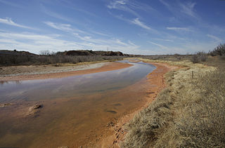
The Salt Fork Brazos River is a braided, highly intermittent stream about 150 mi (240 km) long, heading along the edge of the Llano Estacado about 26 mi (42 km) east-southeast of Lubbock, Texas. From its source, it flows generally east-southeastward to join the Double Mountain Fork to form the Brazos River about 18 mi (29 km) west-northwest of Haskell, Texas. The Salt Fork stretches across portions of Crosby, Garza, Kent, and Stonewall counties of West Texas.
Oak Grove, also known as Rolyat, is an unincorporated community in Bowie County, Texas, United States. According to the Handbook of Texas, the community had a population of 294 in 2000. It is located within the Texarkana metropolitan area.


