
Stonewall County is a county located in the U.S. state of Texas. As of the 2020 census, its population was 1,245. Its county seat is Aspermont. The county was created in 1876 and organized in 1888. It is named for Stonewall Jackson, a general of the Confederate States Army.

Kent County is a county located in the U.S. state of Texas. As of the 2020 census, its population was 753, making it the sixth-least populous county in Texas. Its county seat is Jayton. The county was created in 1876 and later organized in 1892. It is named for Andrew Kent, who died at the Battle of the Alamo. Kent County is a prohibition or entirely dry county, one of four remaining in the state.
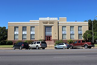
Gillespie County is a county located on the Edwards Plateau in the U.S. state of Texas. As of the 2020 census, its population was 26,725. The county seat is Fredericksburg. It is located in the heart of the rural Texas Hill Country in Central Texas. Gillespie is named for Robert Addison Gillespie, a soldier in the Mexican–American War. It is known as the birthplace of 36th president of the United States of America Lyndon B. Johnson.
Stonewall is an unincorporated community and census-designated place (CDP) in Gillespie County, Texas, United States. The population was 451 at the 2020 census. It was named for Confederate General Thomas J. (Stonewall) Jackson, by Israel P. Nunez, who established a stage station near the site in 1870.

Greenville is a city in Hunt County, Texas, United States, located in Northeast Texas approximately 50 miles (80 km) northeast of Dallas, Texas and 52 miles (84 km) northwest of Canton, Texas. It is the county seat and largest city of Hunt County. As of the 2020 census, the city population was 28,164.

Stamford is a city on the border of Jones and Haskell counties in west-central Texas, United States. The population was 2,907 at the 2020 census. Henry McHarg, president of the Texas Central Railroad, named the site in 1900 for his hometown of Stamford, Connecticut. The city is home to the Texas Cowboy Reunion.

U.S. Route 380 (US 380) is an east–west United States highway. The highway's eastern terminus is in Greenville, Texas at an intersection with Interstate 30, of which the easternmost 3–4 miles are concurrent with US 69 in a loop around the west and south sides of Greenville. Its western terminus is at San Antonio, New Mexico, south of Socorro at an intersection with Interstate 25. It intersected with its parent, U.S. Route 80, at Cisco until 1971, when it was rerouted along the former SH 24 from that highway's western terminus near Old Glory to Greenville. Former U.S. Route 380 from Cisco to near Old Glory became an extension of SH 6. The highway no longer connects to any x80 route. US 380 passes through some of the far northern suburbs of the Dallas/Fort Worth Metroplex, including Denton, Frisco, McKinney and Princeton. The portion in Texas from the New Mexico state line to Jayton was SH 84 before 1939. Its spur, SH 84A, went from Jayton to Aspermont, until 1930, when it became SH 161.
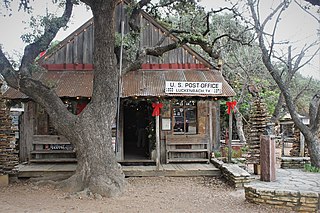
Luckenbach is an unincorporated community 13 miles (19 km) from Fredericksburg in southeastern Gillespie County, Texas, United States. Named for Carl Albert Luckenbach, son of the early settler Jacob Luckenbach, the town is known as a venue for country music and for its German-Texan heritage.

Stonewall Democrats, also known in some states as LGBT Democrats, is a caucus within the Democratic Party that advocates for issues that are relevant to LGBT Americans. The caucus primarily operates through individual chapters or political clubs supporting LGBTQ rights and affiliated with the Democratic Party.

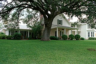
Albert, originally Martinsburg, is a ghost town located 16 miles (25.7 km) southeast of Fredericksburg and one mile (1.6 km) west of the Blanco County line in southeastern Gillespie County, Texas, United States. The town was a stop on the Fredericksburg-Blanco stage route and in 1967 became a stop on the President's Ranch Trail.

Double Mountains is the name of a pair of flat-topped buttes located 13 miles (21 km) southwest of Aspermont in Stonewall County, Texas. While the Handbook of Texas gives their elevation as either 2,000 ft (610 m) or 2,400 ft (732 m), United States Geological Survey maps give the elevation of the western mountain as 2,523 ft (769 m) and that of the eastern mountain as between 2,580 and 2,600 ft. Together, the mountains form part of the high ground dividing the watersheds of the Salt Fork and Double Mountain Fork Brazos River.

Swante M. Swenson was the founder of the SMS ranches in West Texas. It was through his efforts that Swedish immigration to Texas was begun in 1848. In 1972, he was inducted into the Hall of Great Westerners of the National Cowboy & Western Heritage Museum.
The SMS Ranches are a famous group of cattle ranches located in West Texas.
Old Glory is an unincorporated community in Stonewall County, Texas, United States. The community has an estimated population of 100.

Kalgary is an unincorporated community in Crosby County, Texas, United States. According to the Handbook of Texas, the community had an estimated population of 70 in 2000. Kalgary is part of the Lubbock metropolitan area.
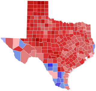
The 2000 United States Senate election in Texas took place on November 7, 2000. Incumbent Republican U.S. Senator Kay Bailey Hutchison won re-election to a second full term. As of 2024, this is the last time Travis County voted Republican in a statewide election and the last time a Republican won every county in the Texas Triangle in a statewide election.

Peacock is an unincorporated community in Stonewall County, Texas, United States. According to the Handbook of Texas, the community had an estimated population of 125 in 2000.

The Double Mountain Fork Brazos River is an ephemeral, sandy-braided stream about 170 mi (280 km) long, heading on the Llano Estacado of West Texas about 11.5 mi (18.5 km) southeast of Tahoka, Texas, flowing east-northeast across the western Rolling Plains to join the Salt Fork, forming the Brazos River about 18 mi (29 km) west-northwest of Haskell, Texas.
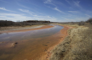
The Salt Fork Brazos River is a braided, highly intermittent stream about 150 mi (240 km) long, heading along the edge of the Llano Estacado about 26 mi (42 km) east-southeast of Lubbock, Texas. From its source, it flows generally east-southeastward to join the Double Mountain Fork to form the Brazos River about 18 mi (29 km) west-northwest of Haskell, Texas. The Salt Fork stretches across portions of Crosby, Garza, Kent, and Stonewall counties of West Texas.

Williams Creek School is located at 5501 South Ranch to Market Road 1623 in Gillespie County, in the U.S. state of Texas. Although now consolidated with the community of Stonewall, the school is actually located south of there in the ghost town of Albert. It was established in 1891 as the Albert School, and was originally a log cabin on Williams Creek. Six years later, it was moved farther from the creek onto a larger piece of land. A new building was constructed of native limestone.


