Canyon Valley, Texas

Last updated
Canyon Valley, Texas
Ghost town
Canyon Valley Texas Bridge.jpg
Pony-truss bridge in Canyon Valley
Relief map of Texas.png
Red pog.svg
Canyon Valley
Location of Canyon Valley in Texas
Usa edcp relief location map.png
Red pog.svg
Canyon Valley
Canyon Valley (the United States)
Coordinates: 33°24′04″N101°20′07″W / 33.40111°N 101.33528°W / 33.40111; -101.33528 Coordinates: 33°24′04″N101°20′07″W / 33.40111°N 101.33528°W / 33.40111; -101.33528 [1]
Country United States
State Texas
County Crosby
Region Llano Estacado
Established1925
Founded byJames A. Shoemaker
Elevation
[1]
2,516 ft (767 m)
Time zone UTC-6 (CST)
Area code 806

Canyon Valley is a ghost town in southern Crosby County, Texas, United States. Today, only a few farms and ranches are scattered across the area.

Contents

Geography

Canyon Valley is located 25 mi (40 km) south of Ralls in southwestern Crosby County. Only one road passes through Canyon Valley, and it is unpaved and passes through a low-water crossing that is often impassable during wet weather. The nearest paved road is Texas State Highway 207, which passes to the west at a distance around 3 mi (4.8 km).

Canyon Valley lies below the Caprock, which defines the southeastern edge of the vast Llano Estacado. It lies within the physiographic region known as the Rolling Plains in the highly eroded valley of the Salt Fork Brazos River.

History

In 1925, James A. Shoemaker brought his family to Crosby County, where he bought a quarter-section of land 3 miles south of the small community of Cap Rock. A three-room house was built on the property, while the land was cleared for farming. Water was hauled in barrels by wagon from the Salt Fork Brazos River until a well was dug with hand tools. [2]

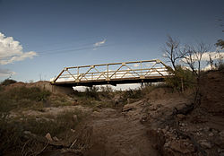
The community grew slowly, but by the early 1930s, Canyon Valley had a cotton gin and a general store. The Valley Gin produced 2,230 bales of cotton in 1934. [3] In 1953, the commissioners court proposed a 5 mi (8.0 km) paved road that would have connected the Valley Gin to the "Ralls and Post Highway" (SH 207). Unfortunately, the proposed road was rejected by the district highway engineer. [4] Although a paved road was never completed, two steel pony-truss bridges were constructed to span Lake Creek and another unnamed dry creek that intermittently becomes a tributary of the Salt Fork Brazos River. The lack of a paved road leading to the community limited the growth of Canyon Valley, and in the late 1950s, the Valley Gin shut down and consolidated with the gin in nearby Kalgary, Texas.

Education

In the early days of Canyon Valley, as more families moved into the area, the number of children grew until enough children were present to justify building a school. In 1926, a one-room schoolhouse was built, and by 1928, a second room was added to the schoolhouse to accommodate the growing student population. [2] The total number of students in Canyon Valley school increased to 66 in 1934, [5] and then reduced to 60 students in 1942. [6] The school served the community until 1947, when it was consolidated with the Cap Rock school to form the Caprock Consolidated Independent School District. [7] A grade school remained in operation at Cap Rock until August 23, 1960, when the district was consolidated with Ralls Independent School District. [8]

See also

Related Research Articles

Crosby County, Texas County in Texas

Crosby County is a county located in the U.S. state of Texas. As of the 2010 census, its population was 6,059. The county seat is Crosbyton. The county was founded in 1876 and later organized in 1886. Both the county and its seat are named for Stephen Crosby, a land commissioner in Texas.

Ralls, Texas City in Texas, United States

Ralls is a city in Crosby County, Texas, United States. It was named after John Robinson Ralls, who with the help of W.E. McLaughlin, laid out the townsite in July 1911. As of the 2010 census, it had a population of 1,944, down from 2,252 at the 2000 census. Ralls is surrounded by productive farm lands that primarily produce cotton and grains, with lesser amounts of soybean, sunflower seed, and vegetables.

Ransom Canyon, Texas Town in Texas, United States

Ransom Canyon is a town in Lubbock County of West Texas, United States. The population was 1,096 at the 2010 census. It is part of the Lubbock Metropolitan Statistical Area.

Fluvanna, Texas Unincorporated community in Texas, United States

Fluvanna is an unincorporated community in Scurry County, Texas, United States. It lies just south of the Llano Estacado high atop the caprock, where Farm-to-Market Road 1269 and Ranch Road 612 intersect.

Caprock Escarpment

The Caprock Escarpment is a term used in West Texas and Eastern New Mexico to describe the geographical transition point between the level High Plains of the Llano Estacado and the surrounding rolling terrain. In Texas, the escarpment stretches around 200 mi (320 km) south-southwest from the northeast corner of the Texas Panhandle near the Oklahoma border. The escarpment is especially notable, from north to south, in Briscoe, Floyd, Motley, Crosby, Dickens, Garza, and Borden Counties. In New Mexico, a prominent escarpment exists along the northernmost extension of the Llano Estacado, especially to the south of San Jon and Tucumcari, both in Quay County, New Mexico. Along the western edge of the Llano Estacado, the portion of the escarpment that stretches from Caprock to Maljamar, New Mexico, is called the Mescalero Ridge.

Salt Fork Red River river in the United States of America

The Salt Fork Red River is a sandy-braided stream about 311 km (193 mi) long, heading on the Llano Estacado of West Texas about 2.9 km (1.8 mi) north of Claude of Armstrong County, Texas, flowing east across the Texas Panhandle and Western Oklahoma to join the Red River about 21 km (13 mi) south of Altus of Jackson County, Oklahoma.

Texas State Highway 207

State Highway 207 is a state Highway that runs from Post, Texas through the South Plains and Texas Panhandle to the Texas/Oklahoma state line.

Blanco Canyon

Blanco Canyon is a canyon located in the U.S. state of Texas. Eroded by the White River into the Caprock Escarpment on the east side of the Llano Estacado, the canyon runs for 34 miles (55 km) in a southeasterly direction, gradually widening from its beginning in southwestern Floyd County to 10 miles (16 km) across at its mouth in southeastern Crosby County. It also gradually deepens from 50 feet (15 m) at its beginning to 300 to 500 feet at its mouth. One side canyon, 5-mile long Crawfish Canyon, was cut by Crawfish Creek as it feeds into the White River from the west.

Battle of Blanco Canyon

The Battle of Blanco Canyon was the decisive battle of Col. Ranald S. Mackenzie's initial campaign against the Comanche in West Texas, and marked the first time the Comanches had been attacked in the heart of their homeland. It was also the first time a large military force explored the heart of Comancheria. On 12 August 1871 Mackenzie and Colonel Benjamin Grierson were asked by Indian Agent Lawrie Tatum to begin an expedition against the Kotsoteka and Quahadi Comanche bands, both of whom had refused to relocate onto a reservation after the Warren Wagon Train Raid. Col. Mackenzie assembled a powerful force consisting of eight companies of the Fourth United States Cavalry, two companies of the Eleventh Infantry, and a group of twenty Tonkawa scouts.

White River (Texas)

The White River is an intermittent stream in the South Plains of Texas and a tributary of the Brazos River of the United States. It rises 8 miles (13 km) west of Floydada in southwestern Floyd County at the confluence of Callahan and Runningwater Draws. From there, it runs southeast for 62 miles (100 km) to its mouth on the Salt Fork of the Brazos River in northwestern Kent County. Besides these two headwaters, which rise near Hale Center and in Curry County, New Mexico, respectively, other tributaries include Pete, Crawfish, and Davidson Creeks. The White River drains an area of 1,690 sq mi (4,377 km2).

Mulberry Creek (Red River tributary)

Mulberry Creek is an intermittent stream about 58 mi (93 km) long, formed as a shallow draw on the high plains of the Llano Estacado in Armstrong County, Texas, and flowing southeastward to join the Prairie Dog Town Fork Red River in Hall County, Texas.

Kalgary, Texas Unincorporated community in Texas, United States

Kalgary is an unincorporated community in Crosby County, Texas, United States. According to the Handbook of Texas, the community had an estimated population of 70 in 2000.

Grassland, Texas Town in Texas, United States

Grassland is an unincorporated community in Lynn County, West Texas, United States. According to the Handbook of Texas, the community had an estimated population of 61 in 2000.

Yellow House Canyon

Yellow House Canyon is about 32 km (20 mi) long, heading in Lubbock, Texas, at the junction of Blackwater Draw and Yellow House Draw, and trending generally southeastward to the edge of the Llano Estacado about 10 km (6.2 mi) east of Slaton, Texas; it forms one of three major canyons along the east side of the Llano Estacado and carries the waters of the North Fork Double Mountain Fork Brazos River.

Double Mountain Fork Brazos River

The Double Mountain Fork Brazos River is an ephemeral, sandy-braided stream about 170 mi (280 km) long, heading on the Llano Estacado of West Texas about 11.5 mi (18.5 km) southeast of Tahoka, Texas, flowing east-northeast across the western Rolling Plains to join the Salt Fork, forming the Brazos River about 18 mi (29 km) west-northwest of Haskell, Texas.

North Fork Double Mountain Fork Brazos River

The North Fork Double Mountain Fork Brazos River is an intermittent stream about 75 mi (121 km) long, heading at the junction of Blackwater Draw and Yellow House Draw in the city of Lubbock, flowing generally southeastward to its mouth on the Double Mountain Fork Brazos River in western Kent County. It crosses portions of Lubbock, Crosby, Garza, and Kent counties in West Texas.

Salt Fork Brazos River

The Salt Fork Brazos River is a braided, highly intermittent stream about 150 mi (240 km) long, heading along the edge of the Llano Estacado about 26 mi (42 km) east-southeast of Lubbock, Texas. From its source, it flows generally east-southeastward to join the Double Mountain Fork to form the Brazos River about 18 mi (29 km) west-northwest of Haskell, Texas. The Salt Fork stretches across portions of Crosby, Garza, Kent, and Stonewall counties of West Texas.

Duffys Peak

Duffy's Peak is a small hill or butte near the Salt Fork Brazos River in Garza County, Texas. Duffy's Peak extends less than 50 ft (15 m) above the river, yet despite its small size, it served as an important landmark for early surveyors of the region and is said to be named for a member of the original survey team who died and was buried nearby in the late 1870s.

Little Red River (Texas)

The Little Red River is an intermittent stream about 30 mi (48 km) long, formed at the confluence of the North Prong and South Prong Little Red River in Briscoe County, Texas, and flowing east-northeastward to join the Prairie Dog Town Fork Red River in Hall County, Texas.

McDonald Creek (Salt Fork Brazos River tributary)

McDonald Creek is an intermittent stream, about 25 mi (40 km) long, heading about 10 mi (16 km) south-southwest of Crosbyton, Texas, and trending generally southeast to join the Salt Fork Brazos River near the community of Verbena, Texas.

References

  1. 1 2 "Canyon Valley". Geographic Names Information System . United States Geological Survey.
  2. 1 2 Crosby County Pioneer Memorial Museum. 1978. A History of Crosby County 1876-1977. Dallas: Taylor, p. 490.
  3. Curry, W.M. (ed). The Crosbyton Review. (Crosbyton, Tex.), Vol. 26, No. 10, p. 4, March 2, 1934. The Portal to Texas History. . Accessed May 5, 2013.
  4. Curry, W.M. (ed). The Crosbyton Review. (Crosbyton, Tex.), Vol. 45, No. 31, p. 1, July 30, 1953. The Portal to Texas History. . Accessed May 5, 2013.
  5. Curry, W.M. (ed). The Crosbyton Review. (Crosbyton, Tex.), Vol. 26, No. 17, p. 1, April 20, 1934. The Portal to Texas History. . Accessed May 5, 2013.
  6. Curry, W.M. (ed). The Crosbyton Review. (Crosbyton, Tex.), Vol. 34, No. 20, p. 1, May 15, 1942. The Portal to Texas History. . Accessed May 5, 2013.
  7. Curry, W.M. (ed). The Crosbyton Review. (Crosbyton, Tex.), Vol. 39, No. 25, p. 1, June 20, 1947. The Portal to Texas History. . Accessed May 5, 2013.
  8. Jenkins, Edloe A. "Cap Rock, TX". Handbook of Texas Online. Retrieved 2013-05-05.