Cone, Texas

Last updated

Cone, Texas
Cone Texas School 2010.jpg
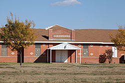
Cone school built in 1923
Relief map of Texas.png
Red pog.svg
Cone
Usa edcp relief location map.png
Red pog.svg
Cone
Coordinates: 33°47′50″N101°23′16″W / 33.79722°N 101.38778°W / 33.79722; -101.38778 [1]
Country United States
State Texas
County Crosby
Region Llano Estacado
Elevation
[1]
3,130 ft (950 m)
Population
 (2000 est.)
  Total20
Time zone UTC-6 (Central (CST))
  Summer (DST) UTC-5 (CDT)
ZIP code
79357
Area code 806
GNIS feature ID1354866 [1]
Website Handbook of Texas

Cone is an unincorporated community in Crosby County, Texas, United States. It lies on U.S. Route 62, thirty-four miles northeast of Lubbock, has an estimated population of 70. Cone is part of the Lubbock Metropolitan Statistical Area

Contents

History

Named for early settler James Stanton Cone, the community of Cone was established in 1901, and was granted a post office sometime around 1903. On 14 February 1903, the Cone School began teaching students on land donated by a man by the name of Charles Travis, and by 1939 the community was home to 150 residents. [2]

After the 1930s, however, the population began to decline. By 1965, the Cone school's enrollment had fallen so low that the district was forced to consolidate, sending the few remaining pupils to attend school in Ralls. By 1988 the population had fallen to less than fifty, and only three businesses and the post office remained in operation. By 2000, however, the population had rebounded to its current level of approximately 70. Cone school building was purchased in 1966 by The Primitive Baptist Foundation and repurposed it as the Harmony Plains Singing School.

Education

Cone is served by the Ralls Independent School District.

See also

Related Research Articles

<span class="mw-page-title-main">Lubbock County, Texas</span> County in Texas, United States

Lubbock County is a county located in the U.S. state of Texas. The 2020 census placed the population at 310,639. Its county seat and largest city is Lubbock. The county was created in 1876 and organized in 1891. It is named for Thomas Saltus Lubbock, a Confederate colonel and Texas Ranger.

<span class="mw-page-title-main">Crosby County, Texas</span> County in Texas, United States

Crosby County is a county located in the U.S. state of Texas. As of the 2020 census, its population was 5,133. The county seat is Crosbyton. The county was founded in 1876 and later organized in 1886. Both the county and its seat are named for Stephen Crosby, a land commissioner in Texas.

<span class="mw-page-title-main">Ralls, Texas</span> City in Texas, United States

Ralls is a city in Crosby County, Texas, United States. It was named after John Robinson Ralls, who, with the help of W.E. McLaughlin, laid out the townsite in July 1911. As of the 2010 census, it had a population of 1,944, down from 2,252 at the 2000 census. Ralls is surrounded by productive farmlands that primarily produce cotton and grains, with lesser amounts of soybean, sunflower seed, and vegetables.

<span class="mw-page-title-main">Floydada, Texas</span> City in Texas, United States

Floydada is a city in and the county seat of Floyd County, Texas, United States. This rural community lies on the high plains of the Llano Estacado in West Texas and is sometimes referred to as the Pumpkin Capital of Texas. The population was 3,038 at the 2010 census, down from 3,676 at the 2000 census.

<span class="mw-page-title-main">Caprock Escarpment</span> Geographical transition in Texas and New Mexico

The Caprock Escarpment is a term used in West Texas and Eastern New Mexico to describe the geographical transition point between the level High Plains of the Llano Estacado and the surrounding rolling terrain. In Texas, the escarpment stretches around 200 mi (320 km) south-southwest from the northeast corner of the Texas Panhandle near the Oklahoma border. The escarpment is especially notable, from north to south, in Briscoe, Floyd, Motley, Crosby, Dickens, Garza, and Borden Counties. In New Mexico, a prominent escarpment exists along the northernmost extension of the Llano Estacado, especially to the south of San Jon and Tucumcari, both in Quay County, New Mexico. Along the western edge of the Llano Estacado, the portion of the escarpment that stretches from Caprock to Maljamar, New Mexico, is called the Mescalero Ridge.

Acuff is an unincorporated farming community in northeastern Lubbock County, Texas, United States. It is part of the Lubbock Metropolitan Statistical Area.

<span class="mw-page-title-main">Slide, Texas</span> Unincorporated community in Texas, United States

Slide is an unincorporated community in Lubbock County, Texas, United States. It lies at the junction of FM 1730 and FM 41, 13 miles south of Lubbock, and has an estimated population of 44. The community is part of the Lubbock metropolitan area.

<span class="mw-page-title-main">Woodrow, Texas</span> Unincorporated community in Texas, United States

Woodrow is an unincorporated community in southern Lubbock County, Texas, United States. It lies on U.S. Route 87, ten miles south of Lubbock, and has an estimated population of 85. It is part of the Lubbock Metropolitan Statistical Area.

<span class="mw-page-title-main">Southland, Texas</span> Unincorporated community in Texas, United States

Southland is an unincorporated community in Garza County, Texas, United States. It lies along the eastern edge of the Llano Estacado on U.S. Route 84, twenty miles northwest of Post.

<span class="mw-page-title-main">Dougherty, Floyd County, Texas</span> Unincorporated community in Texas, United States

Dougherty is a small unincorporated community in Floyd County, Texas, United States.

<span class="mw-page-title-main">Blanco Canyon</span>

Blanco Canyon is a canyon located in the U.S. state of Texas. Eroded by the White River into the Caprock Escarpment on the east side of the Llano Estacado, the canyon runs for 34 miles (55 km) in a southeasterly direction, gradually widening from its beginning in southwestern Floyd County to 10 miles (16 km) across at its mouth in southeastern Crosby County. It also gradually deepens from 50 feet (15 m) at its beginning to 300 to 500 feet at its mouth. One side canyon, 5-mile long Crawfish Canyon, was cut by Crawfish Creek as it feeds into the White River from the west.

<span class="mw-page-title-main">White River (Texas)</span> River in Texas, United States

The White River is an intermittent stream in the South Plains of Texas and a tributary of the Brazos River of the United States. It rises 8 miles (13 km) west of Floydada in southwestern Floyd County at the confluence of Callahan and Runningwater Draws. From there, it runs southeast for 62 miles (100 km) to its mouth on the Salt Fork of the Brazos River in northwestern Kent County. Besides these two headwaters, which rise near Hale Center and in Curry County, New Mexico, respectively, other tributaries include Pete, Crawfish, and Davidson Creeks. The White River drains an area of 1,690 sq mi (4,377 km2).

<span class="mw-page-title-main">Kalgary, Texas</span> Unincorporated community in Texas, United States

Kalgary is an unincorporated community in Crosby County, Texas, United States. According to the Handbook of Texas, the community had an estimated population of 70 in 2000.

<span class="mw-page-title-main">Estacado, Texas</span> Place in Texas, United States

Estacado is a ghost town in Crosby and Lubbock Counties in the U.S. state of Texas. Located along Farm to Market Road 1527, it was established in 1879 as a Religious Society of Friends (Quaker) colony by Paris Cox and originally named Maryetta after his wife. In 1886, it became the first government seat of Crosby County. In 1936, Recorded Texas Historic Landmark number 4779 was designated to commemorate the founding of Estacado.

<span class="mw-page-title-main">Posey, Texas</span> Unincorporated community in Texas, United States

Posey is an unincorporated community located on the level plains of the Llano Estacado, approximately 11 mi (18 km) southeast of Lubbock in southeastern Lubbock County, Texas, United States.

<span class="mw-page-title-main">Barwise, Texas</span> Unincorporated community in Texas, United States

Barwise is a small, unincorporated community located on the level plains of the Llano Estacado about 10 mi (16 km) west of Floydada in western Floyd County, Texas. The town was founded in 1928 after the Fort Worth and Denver South Plains Railway Company laid tracks through the area. The rail spur that passes through Barwise extended from the Fort Worth and Denver Railway junction at Estelline to Lubbock and Plainview.

<span class="mw-page-title-main">Heckville, Texas</span> Unincorporated community in Texas, United States

Heckville is an unincorporated community located on the high plains of the Llano Estacado, approximately 16 mi (26 km) northeast of Lubbock or 7 mi (11 km) north of Idalou in northeastern Lubbock County, Texas, United States. This small town was named after Henry Heck, who built a cotton gin to serve the community in 1948.

<span class="mw-page-title-main">Becton, Texas</span> Unincorporated community in Texas, United States

Becton is an unincorporated community in northeastern Lubbock County, Texas, United States, approximately 18 mi (29 km) northeast of Lubbock. This small rural community lies on the high plains of the Llano Estacado in West Texas.

<span class="mw-page-title-main">Close City, Texas</span> Unincorporated community in Texas, United States

Close City is an unincorporated community in western Garza County, approximately 6.5 mi (10.5 km) west-northwest of Post. The small rural community lies on the High Plains of the Llano Estacado in West Texas.

<span class="mw-page-title-main">Canyon Valley, Texas</span> Ghost town in Texas, United States

Canyon Valley is a ghost town in southern Crosby County, Texas, United States. Today, only a few farms and ranches are scattered across the area.

References