Mont Ripley is a ski hill located in Franklin Township, Houghton County, in Michigan's Upper Peninsula. The site is just outside the cities of Hancock and Houghton. It is owned by Michigan Technological University. It was founded in the early 1900s by Fred Pabst Jr.. With the addition of snow making in 2000, the season has been extended from late November to late March or early April.

The Tegelberg Cable Car, on the Tegelberg mountain near Schwangau in southern Bavaria. The cable car is 2,146.18 metres long, climbs a height of 892.5 metres, has a carrying cable of 48 mm in diameter and a hauling cable of 26 mm in diameter. It has two cabins each capable of transporting up to 44 persons. They are driven by a 2,540 KW engine. The cableway has a 38 metre high support pillar, made of reinforced concrete.

Cölbe is a community in Marburg-Biedenkopf district in Hesse, Germany.
Hackney, is a village in Guyana, standing on the eastern bank of the Pomeroon River, 11 km from its mouth. Formerly the business centre for residents of the coconut estates of the lower Pomeroon River, Hackney is still of some importance. It provides a primary school and church for residents of the surrounding area.

The Landtag of Baden-Württemberg is the diet of the German state of Baden-Württemberg. It convenes in Stuttgart and currently consists of 154 members of five political parties. The majority before the 2021 election was a coalition of the Alliance '90/The Greens and the CDU, supporting the cabinet of Green Minister-President Winfried Kretschmann.
South Point is an unincorporated community in Accomack County, Virginia.

Əmirməhmud is a village in the Agdash Rayon of Azerbaijan. The village forms part of the municipality of Şəmsabad.
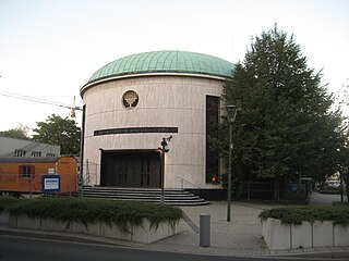
The New Synagogue is the synagogue of the Jewish community in Düsseldorf, Germany. The synagogue was built in the Golzheim district, far from the site of the former synagogue, which was located in the city center at Kasernenstraße. There the synagogue, built in 1905, was pillaged and burned by SA men during the Kristallnacht in 1938.

Krowia Góra is a village in the administrative district of Gmina Łoniów, within Sandomierz County, Świętokrzyskie Voivodeship, in south-central Poland. It lies approximately 3 kilometres (2 mi) east of Łoniów, 20 km (12 mi) south-west of Sandomierz, and 76 km (47 mi) south-east of the regional capital Kielce.
Koło is a village in the administrative district of Gmina Brody, within Żary County, Lubusz Voivodeship, in western Poland, close to the German border. It lies approximately 6 kilometres (4 mi) north of Brody, 34 km (21 mi) north-west of Żary, and 52 km (32 mi) west of Zielona Góra.
Wierzch is a village in the administrative district of Gmina Głogówek, within Prudnik County, Opole Voivodeship, in south-western Poland, close to the Czech border. It lies approximately 7 kilometres (4 mi) west of Głogówek (Oberglogau), 15 km (9 mi) east of Prudnik, and 37 km (23 mi) south of the regional capital Opole.
Łasko is a village in the administrative district of Gmina Bierzwnik, within Choszczno County, West Pomeranian Voivodeship, in north-western Poland. It lies approximately 9 kilometres (6 mi) north-east of Bierzwnik, 28 km (17 mi) east of Choszczno, and 89 km (55 mi) south-east of the regional capital Szczecin.

Rothenthurn is a castle in the municipality of Spittal an der Drau in Carinthia, Austria.

Burg Freundsberg is a castle in Tyrol, Austria, that was constructed in the year of 1150 by the lords of Freundsberg. Burg Freundsberg is 675 metres (2,215 ft) above sea level. Originally the castle consisted out of a single keep, which is still intact up to this date. The chapel next to it was built afterwards in the year 1177. In 1467 the castle was sold to Archduke Sigismund of Austria, who rebuilt the castle and called it Sigismundruh for the duration of his reign.

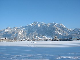
The Ammergau Alps are a mountain range in the Northern Limestone Alps in the states of Bavaria (Germany) and Tyrol (Austria). They cover an area of about 30 x 30 km and begin at the outer edge of the Alps. The highest summit is the Daniel which has a height of 2,340 metres (7,680 ft).

Aeroport District is an administrative district (raion) of the Northern Administrative Okrug and one of the 125 raions of Moscow, Russia. The area of the district is 4.58 square kilometers (1.77 sq mi).
Arabi Island is one of the Saudi Arabian islands near Farsi Island in the Persian Gulf. The island measures ten hectares in area.
Flint fields are large natural deposits of flint. They are found in numerous Jurassic and Cretaceous beds across the whole of Europe.

Elm Grove is a census-designated place (CDP) in Adair County, Oklahoma, United States. The population was 198 at the 2010 census.
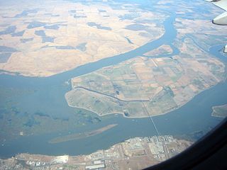
West Island is a small island in the San Joaquin River, California. It is part of Sacramento County. Its coordinates are 38°01′24″N121°46′43″W. It is shown, labeled "Webers Island", on an 1850 survey map of the San Francisco Bay area made by Cadwalader Ringgold and an 1854 map of the area by Henry Lange.