
Pahang, officially Pahang Darul Makmur with the Arabic honorific Darul Makmur is a sultanate and a federal state of Malaysia. It is the third largest state in the country and the largest state in Peninsular Malaysia, and the ninth most populace. The state occupies the basin of the Pahang River, and a stretch of the east coast as far south as Endau. The state borders the Malaysian states of Kelantan and Terengganu to the north, Perak, Selangor and Negeri Sembilan to the west and Johor to the south, with the South China Sea is to the east. The Titiwangsa mountain range that forms a natural divider between the peninsula's east and west coasts is spread along the north and south of the state, peaking at Mount Tahan, which is 2,187 metres (7,175 ft) high. Although two thirds of the state is covered by dense rain forest, its central plains are intersected by numerous rivers, and along the coast there is a 32-kilometre (20 mi) wide expanse of alluvial soil that includes the deltas and estuarine plains of the Kuantan, Pahang, Rompin, Endau, and Mersing Rivers.

Taman Negara is a national park in Peninsular Malaysia. It was established in 1938 and 1939 as the King George V National Park after Theodore Hubback lobbied the sultans of Pahang, Terengganu and Kelantan to set aside a piece of land that covers the three states for the creation of a protected area. After independence, it was renamed Taman Negara, which means "national park" in Malay.

The Pahang River mainly flows through the state of Pahang, Malaysia. Its drainage basin covers its Pahang as well as the neighbouring state of Negeri Sembilan.

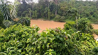
Kuala Tahan is a Malaysian village located at the confluence of the Tahan and Tembiling Rivers, in Jerantut District, Pahang.

The Jempol District is the largest district in the Malaysian state of Negeri Sembilan. The district borders Jelebu District to the northwest, Kuala Pilah District to the west, Tampin District to the south, Bera District, Pahang to the northeast and Segamat District, Johor to the east. Bandar Seri Jempol and Bahau are the principal towns in Jempol.

The Jerantut District is a district in north-eastern Pahang, Malaysia. Jerantut is home to the National Park.
Rompin River is a river in the Malaysian state of Pahang. It flows through southeastern Pahang before emptying into the South China Sea.
Belimbing is a small town in Pekan District, Pahang, Malaysia, located near Pahang River and Chini Lake. Belimbing means star fruit in Malay.
The Laluan Penarikan were a series of portage routes across the Malay Peninsula. The most famous of these routes connected the Muar River with the Pahang River. The Penarikan shortened the journey of water vessels sailing between the Strait of Malacca and the South China Sea.

Telok Mas is a small town in Melaka Tengah District, Malacca, Malaysia.
The Jelai River is a 97.14 km long river in Pahang, Malaysia. It is one of the two main tributaries of the Pahang River, the longest river in Peninsular Malaysia.

Terengganu Malay is a Malayic language spoken in the Malaysian state of Terengganu all the way southward to coastal Pahang and northeast Johor. It is the native language of Terengganu Malays and highly localized Chinese Peranakan community as well as a second language among the smaller Indian minority.

The Federal Route 102, also known as Pos Betau–Lembah Bertam Road, is a 79.1-kilometre (49.2 mi) federal highway in Pahang, Malaysia. It is built as the third access road to the district of Cameron Highlands, Pahang after the Federal Route 59 and 185. The completion of the highway makes it possible for Pahangite motorists to visit Cameron Highlands without leaving the state of Pahang.
Lipis River is a river of Pahang, Malaysia.
Pahang Malay is a Malayic language spoken in the Malaysian state of Pahang. It is regarded as the dominant Malay dialect spoken along the vast riverine systems of Pahang, but co-exists with other Malay dialects traditionally spoken in the state. Along the coastline of Pahang, Terengganu Malay is spoken in a narrow strip of sometimes discontiguous fishing villages and towns. Another dialect spoken in Tioman island is a distinct Malay variant and most closely related to Riau Archipelago Malay subdialect spoken in Natuna and Anambas islands in the South China Sea, together forming a dialect continuum between the Bornean Malay and the Mainland Peninsular/Sumatran Malay.

Tun Abdul Razak Stadium is a football stadium in Jengka, Maran District, Pahang, Malaysia. It is currently used primarily for football matches. The stadium holds 25,000 people and opened in 2015. It was named after former prime minister of Malaysia, Tun Abdul Razak and currently is the home stadium of Felda United.
Pahang Malays are a sub-group of Malay people native to the state of Pahang, in the east coast of Peninsular Malaysia. With population of approximately 1.08 million people, they constitutes 70% of Pahang state's population, making them the dominant ethnic group in the state. Their language, Pahang Malay is one of many Malayan languages spoken in the region that belong to the Malayo-Polynesian group of Austronesian family.

Old Pahang Kingdom was a historical Malay polity centred in the Pahang region on the east coast of the Malay Peninsula. The polity appeared in foreign records from as early as the 5th century and at its height, covered much of modern state of Pahang and the entire southern part of the peninsula. Throughout its pre-Melakan history, Pahang was established as a mueang or naksat of some major regional Malayic mandalas including Langkasuka, Srivijaya and Ligor. Around the middle of the 15th century, it was brought into the orbit of Melaka Sultanate and subsequently established as a vassal Muslim Sultanate in 1470, following the coronation of the grandson of the former Maharaja as the first Sultan of Pahang.

Jerantut is a town in Jerantut District, Pahang, Malaysia. It is the largest district in the State of Pahang. It covers an area of 2,900 square miles. Bordered by the States of Kelantan and Terengganu in the North, Temerloh and Maran districts in the South, Kuala Lipis and Raub districts in the West and Kuantan district and Terengganu state in the East. It has 10 mukims consisting of 295 villages administered under 58 JKKK. Jerantut District Council was gazetted on 18 February 1982. Jerantut District Council, formerly known as Jerantut Town Board is the local authority of Jerantut town.
2020–2021 Malaysian floods is an event when several states in Malaysia were flooded in late 2020 and early 2021. Floods caused about tens of thousands of people to be evacuated to evacuation centers. The floods also claimed several lives, causing almost all types of land transport in the areas affected by the floods to be cut off.
