
The Columbia River is the largest river in the Pacific Northwest region of North America. The river forms in the Rocky Mountains of British Columbia, Canada. It flows northwest and then south into the U.S. state of Washington, then turns west to form most of the border between Washington and the state of Oregon before emptying into the Pacific Ocean. The river is 1,243 miles long, and its largest tributary is the Snake River. Its drainage basin is roughly the size of France and extends into seven states of the United States and one Canadian province. The fourth-largest river in the United States by volume, the Columbia has the greatest flow of any North American river entering the Pacific. The Columbia has the 36th greatest discharge of any river in the world.
The Pacific Northwest (PNW), sometimes referred to as Cascadia, is a geographic region in western North America bounded by its coastal waters of the Pacific Ocean to the west and, loosely, by the Rocky Mountains to the east. Though no official boundary exists, the most common conception includes the U.S. states of Oregon, Washington, and Idaho, and the Canadian province of British Columbia. Some broader conceptions reach north into Alaska and Yukon, south into northern California, and east into western Montana. Other conceptions may be limited to the coastal areas west of the Cascade and Coast mountains. The variety of definitions can be attributed to partially overlapping commonalities of the region's history, culture, geography, society, ecosystems, and other factors.

The Willamette River is a major tributary of the Columbia River, accounting for 12 to 15 percent of the Columbia's flow. The Willamette's main stem is 187 miles (301 km) long, lying entirely in northwestern Oregon in the United States. Flowing northward between the Oregon Coast Range and the Cascade Range, the river and its tributaries form the Willamette Valley, a basin that contains two-thirds of Oregon's population, including the state capital, Salem, and the state's largest city, Portland, which surrounds the Willamette's mouth at the Columbia.

Multnomah County is one of the 36 counties in the U.S. state of Oregon. As of the 2020 census, the county's population was 815,428. Multnomah County is part of the Portland–Vancouver–Hillsboro, OR–WA Metropolitan Statistical Area. Though smallest in area, Multnomah County is the state's most populous county. Its county seat, Portland, is the state's largest city.

Hood River County is one of the 36 counties in the U.S. state of Oregon. As of the 2020 census, the population was 23,977. The county seat is Hood River. The county was established in 1908 and is named for the Hood River, a tributary of the Columbia River. Hood River County comprises the Hood River, OR Micropolitan Statistical Area. The Hood River Valley produces apples, pears, and cherries. Situated between Mount Hood and the Columbia River in the middle of the Columbia River Gorge, Hood River County is a popular destination for outdoor enthusiasts, such as windsurfers, mountain-bikers, skiers, hikers, kayakers, and many more.

Chinookan peoples include several groups of Indigenous people of the Pacific Northwest in the United States who speak the Chinookan languages. Since at least 4000 BCE Chinookan peoples have resided along the Lower and Middle Columbia River (Wimahl) from the river's gorge downstream (west) to the river's mouth, and along adjacent portions of the coasts, from Tillamook Head of present-day Oregon in the south, north to Willapa Bay in southwest Washington. In 1805 the Lewis and Clark Expedition encountered the Chinook Tribe on the lower Columbia.

The Deschutes River in central Oregon is a major tributary of the Columbia River. The river provides much of the drainage on the eastern side of the Cascade Range in Oregon, gathering many of the tributaries that descend from the drier, eastern flank of the mountains. The Deschutes provided an important route to and from the Columbia for Native Americans for thousands of years, and then in the 19th century for pioneers on the Oregon Trail. The river flows mostly through rugged and arid country, and its valley provides a cultural heart for central Oregon. Today the river supplies water for irrigation and is popular in the summer for whitewater rafting and fishing.

Quercus garryana is an oak tree species of the Pacific Northwest, with a range stretching from southern California to southwestern British Columbia. It is commonly known as the Oregon white oak or Oregon oak or, in Canada, the Garry oak. It grows from sea level to an altitude of 690 feet in the northern part of its range, and from 980 to 5,900 ft in the south of the range in California. The eponymous Nicholas Garry was deputy governor of the Hudson's Bay Company.

Multnomah Falls is a waterfall located on Multnomah Creek in the Columbia River Gorge, east of Troutdale, between Corbett and Dodson, Oregon, United States. The waterfall is accessible from the Historic Columbia River Highway and Interstate 84. Spanning two tiers on basalt cliffs, it is the tallest waterfall in the state of Oregon at 620 ft (189 m) in height. The Multnomah Creek Bridge, built in 1914, crosses below the falls, and is listed on the National Register of Historic Places.
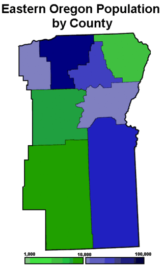
Eastern Oregon is a region of the U.S. state of Oregon. It is not an officially recognized geographic entity; thus, the boundaries of the region vary according to context. It is sometimes understood to include only the eight easternmost counties in the state; in other contexts, it includes the entire area east of the Cascade Range. Cities in the basic eight-county definition include Baker City, Burns, Hermiston, Pendleton, Boardman, John Day, La Grande, and Ontario. Umatilla County is home to the largest population base in Eastern Oregon, accounting for 42% of the region's residents. Hermiston, located in Umatilla County, is the largest city in the region, accounting for 10% of the population. Major industries include transportation/warehousing, timber, agriculture and tourism. The main transportation corridors are I-84, U.S. Route 395, U.S. Route 97, U.S. Route 26, U.S. Route 30, and U.S. Route 20.
The Multnomah are a tribe of Chinookan people who live in the area of Portland, Oregon, in the United States. Multnomah villages were located throughout the Portland basin and on both sides of the Columbia River. The Multnomah speak a dialect of the Upper Chinookan language in the Oregon Penutian family.

Rooster Rock State Park is a state park located east of Corbett, in the U.S. state of Oregon. One of the features of the park is Rooster Rock, a column of basalt forming a natural obelisk, which stands near the south side of the Columbia River Gorge, in the lee of Crown Point. The park is administered by the Oregon Parks and Recreation Department.

Svensen is an unincorporated community and census-designated place (CDP) on the Columbia River in Clatsop County, Oregon, United States, named after early settler Peter Svensen. There was a post office in Svensen from 1895 to 1944. Since the closure of the Svensen Post Office, mail service has been provided by rural carriers of the Astoria, Oregon post office. Svensen is within the Knappa School District.
The state of Oregon in the United States has established an international reputation for its production of wine, ranking fourth in the country behind California, Washington, and New York. Oregon has several different growing regions within the state's borders that are well-suited to the cultivation of grapes; additional regions straddle the border between Oregon and the states of Washington and Idaho. Wine making dates back to pioneer times in the 1840s, with commercial production beginning in the 1960s.

The Wahkiakum County ferry crosses the lower Columbia River between the U.S. states of Washington and Oregon, and is the last regularly scheduled car ferry to cross the Columbia River between the two states.

Interstate 84 (I-84) in the U.S. state of Oregon is a major Interstate Highway that traverses the state from west to east. It is concurrent with U.S. Route 30 (US 30) for most of its length and runs 376 miles (605 km) from an interchange with I-5 in Portland to the Idaho state line near Ontario. The highway roughly follows the Columbia River and historic Oregon Trail in northeastern Oregon, and is designated as part of Columbia River Highway No. 2 and all of the Old Oregon Trail Highway No. 6; the entire length is also designated as the Vietnam Veterans Memorial Highway. I-84 intersects several of the state's main north–south roads, including US 97, US 197, I-82, and US 395.

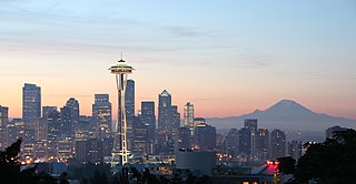
Oregon is a state in the Pacific Northwest region of the United States. Oregon is a part of the Western United States, with the Columbia River delineating much of Oregon's northern boundary with Washington, while the Snake River delineates much of its eastern boundary with Idaho. The 42° north parallel delineates the southern boundary with California and Nevada. The western boundary is formed by the Pacific Ocean.
Clifton is an unincorporated community in Clatsop County, Oregon, United States. It is located north of U.S. Route 30, about nine miles northwest of Westport on the south bank of the Columbia River. It is on Clifton Channel across from Tenasillahe Island.
Clifton is an unincorporated locale in Hood River County, Oregon, United States. It is located about 3 miles west of the city of Hood River. The name originates from the drop in elevation Interstate 84 takes from the cliffs there, which are 250 feet above the Columbia River.
The Holiday Inn Portland-Columbia Riverfront is a hotel in Portland, Oregon. The hotel is located on Hayden Island, along the Columbia River east of the Interstate Bridge. Construction cost $18 million.

