
U.S. Route 641 (US 641) is a U.S. Route in Tennessee and Kentucky. It runs for 165.45 miles (266.27 km) from US 64 south of Clifton, Tennessee to an intersection with US 60 in Marion, Kentucky. While it is considered a spur route of U.S. Route 41, the two routes no longer connect.

Mississippi Highway 182 designates the old two-lane highway for U.S. Route 82 (US 82) where the current US 82 occupies a new right-of-way. Some of the towns with a segment of MS 182 are Winona, Kilmichael, Eupora, Mayhew, Starkville, and Columbus.
Pennsylvania Route 61 is an 81.8-mile-long (131.6 km) state highway that is located in the Commonwealth of Pennsylvania in the United States. The route is signed on a north–south direction, running from U.S. Route 222 Business in Reading northwest to US 11/US 15/PA 147 in Shamokin Dam.
Pennsylvania Route 29 is a 118-mile-long (190 km) north–south state highway that runs through most of eastern Pennsylvania.

State Route 22 is a 172.8-mile long (278.1 km) south-to-north state highway in the western part of Tennessee, United States. It begins at the Mississippi state line in McNairy County, where the roadway continues as Mississippi Highway 2. It ends at the Kentucky state line in Lake County, when it crosses into the Kentucky Bend, a detached portion of Fulton County, Kentucky. The monument for the 1862 Battle of Island Number Ten in the American Civil War is located on SR 22, about 3 mi (4.8 km) north of Tiptonville.

Pennsylvania Route 35 is a 70.8-mile-long (113.9 km) state highway located in central Pennsylvania. The southern terminus of the route is at U.S. Route 522 (US 522) near Shade Gap. The northern terminus is at US 11/US 15 in Selinsgrove.
Pennsylvania Route 87 is a 69.3-mile-long (111.5 km) north–south state highway located in northern Pennsylvania. The southern terminus of the route is at exit 21 of Interstate 180 (I-180)/U.S. Route 220 in Montoursville. The northern terminus is at US 6 in Washington Township.

Pennsylvania Route 192 is a state highway located in central Pennsylvania. The western terminus of the route is at PA 144 in Centre Hall. The eastern terminus is at U.S. Route 15 in Lewisburg.
Pennsylvania Route 641 is a state route that is located in Central Pennsylvania in the United States. The route is 57.9 miles (93.2 km) long and runs from U.S. Route 522 near Shade Gap east to US 11/US 15 in Camp Hill.
Pennsylvania Route 108 is a highway in Western Pennsylvania that runs for 32 miles (51 km) from the Ohio state line near SNPJ to PA 8 in Adams Corner. PA 108 intersects Interstate 376 (I-376) near New Castle and U.S. Route 19 (US 19) near Harlansburg. PA 108 also has an interchange with Interstate 79 (I-79) at exit 105.

Pennsylvania Route 168 is a highway in Western Pennsylvania that runs for 55 miles (89 km) from PA 18 in Frankfort Springs to PA 208 in Volant. PA 168 intersects or runs concurrently with PA 18 at several points, including New Castle.
Pennsylvania Route 144 is a state highway located in the U.S. state of Pennsylvania, covering a distance of about 109 miles (175 km). The southern terminus is located near an interchange with U.S. Route 322 (US 322) at State Route 2015 in Potter Township while the northern terminus is located at US 6 in Galeton. Between Snow Shoe and Renovo, PA 144 is known as the High Plateau Scenic Byway, a Pennsylvania Scenic Byway.
Pennsylvania Route 413 is a 31-mile-long (50 km), north–south state highway in Bucks County, Pennsylvania. The route runs from the New Jersey state line on the Burlington–Bristol Bridge over the Delaware River outside Bristol, where the road continues as Route 413 into New Jersey, north to PA 611 in Bedminster Township. The route passes through the lower and central portions of Bucks County, serving Bristol, Levittown, Langhorne, Newtown, and Buckingham. The route intersects U.S. Route 13 and Interstate 95 (I-95) near Bristol, I-295 near Penndel, US 1 in Langhorne Manor, and US 202 in Buckingham.

State Route 69 is a state highway in West and Middle Tennessee that runs parallel to the Tennessee River for the majority of its length. SR 69 carries both primary and secondary highway designations and is routed through rural areas.

Pennsylvania Route 254 is a 30-mile-long (48 km) state highway located in Northumberland, Montour, and Columbia counties in Pennsylvania. The western terminus is at PA 405 in Milton. The eastern terminus is at PA 487 near Benton.
State Route 60 is a north-south major state route in Eastern Tennessee. It covers 54 miles (87 km) and runs from the Tennessee-Georgia state line in Bradley County to Dayton joining US 27.

State Route 55 is an east–west highway in Middle Tennessee. The road begins at SR 50 in Lynchburg and ends at U.S. Route 70S and SR 380 in McMinnville. The current length is 49.3 mi (79.3 km). SR 55 heads northeast from Lynchburg to Tullahoma as a two-lane road. In Tullahoma, the route runs concurrent with US 41A. From here, SR 55 heads northeast as a multilane highway to Manchester, where it intersects US 41 and Interstate 24 (I-24). The route continues northeast, serving Summitville and Morrison before it reaches McMinnville.
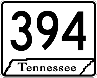
State Route 394 is a west–east state highway in Sullivan County, Tennessee. It serves as southern bypass of Bristol and as a connector route from Interstate 81 (I-81) to Bristol Motor Speedway. The western terminus is at an intersection with U.S. Route 11W northwest of Blountville and the eastern terminus is at a junction with US 421 southeast of Bristol. The route heads southeast and crosses I-81 before passing through Blountville. From here, SR 394 continues southeast to an interchange with US 11E/US 19 near Bristol Motor Speedway, where it turns northeast and continues to US 421.

At least 17 special routes of U.S. Route 11 (US 11) and at least one of US 11E have existed.
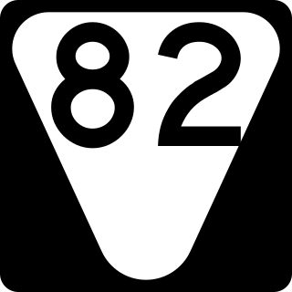
State Route 82 is a secondary state highway that runs through Moore and Bedford counties in south central Tennessee in the United States. The route runs from an intersection with SR 55 in Lynchburg north and east to SR 64 near Beech Grove.

