
U.S. Route 411 (US 411) is an alternate parallel-highway associated with US 11. US 411 extends for about 313 miles (504 km) from US 78 in Leeds, Alabama, to US 25W/US 70 in Newport, Tennessee. US 411 travels through northeastern Alabama, northwestern Georgia, and southeastern Tennessee. Notable towns and cities along its route include Gadsden, Alabama; Rome, Georgia; Cartersville, Georgia; Maryville, Tennessee; Sevierville, Tennessee, and Newport, Tennessee.
State Route 56 is a 164-mile (265 km) highway that runs south to north in Middle Tennessee.
State Route 22 is a 172.8-mile long (278.1 km) south-to-north state highway in the western part of Tennessee, United States. It begins at the Mississippi state line in McNairy County, where the roadway continues as Mississippi Highway 2. It ends at the Kentucky state line in Lake County, when it crosses into the Kentucky Bend, a detached portion of Fulton County, Kentucky.

State Route 119 is an east–west highway serving rural sections of west-central Ohio. It begins just west of Fort Recovery at the eastern terminus of Indiana State Road 26. It travels through Mercer, Auglaize, and Shelby counties to end at SR 65 in Jackson Township, Shelby County. The route is 42-mile-long (68 km) and serves the medium-size villages of Fort Recovery, St. Henry, Minster, and Anna.
State Route 14 is a south–north route from the Mississippi border in Memphis, Tennessee to an intersection with State Route 54 in Tipton County.

State Route 99 is a long east–west highway in Middle Tennessee. The route travels through large sections of rural areas and for most of the length is a secondary highway. The route begins near Waynesboro and ends in Bradyville after logging 126.7 mi (203.9 km) and passing through six counties.
State Route 20 (SR 20) is a 143.04-mile (230.20 km) long east–west primary state highway that begins in Dyersburg and ending near Summertown. SR 20 is unsigned and concurrent with U.S. Route 412 (US 412) for its entire length, except for a short section between Hohenwald and Summertown. Along its route, SR 20 traverses parts of both Middle Tennessee and West Tennessee.
State Route 8 is a south–north route that connects Chattanooga to McMinnville in East & Middle Tennessee
State Route 10 is a south–north route from the Alabama state line in Lincoln County, Tennessee to the Kentucky state line in Macon County.
State Route 15 is a west–east route from Memphis to Monteagle. For much of its route it has an unsigned concurrency with U.S. Route 64. SR 15 does travel through the southern part of all 3 Grand Divisions of the state: West Tennessee, Middle Tennessee, and East Tennessee.
State Route 76 (SR 76) is a state highway in Tennessee, traversing the state in a northeast-southwest axis from east of Memphis to north of Nashville. SR 76 is unique in that it actually changes its cardinal directions in Clarksville at the junction with US 41A and US 41A Bypass.

U.S. Route 23 (US 23) in the U.S. state of Georgia, is a north–south United States highway that travels from the St. Marys River south-southeast of Folkston to the North Carolina state line, in the northern part of Dillard.

U.S. Route 129 (US 129) is a 375-mile-long (604 km) U.S. Highway in the U.S. state of Georgia. It travels south-to-north from the Florida state line, south of Statenville, to the North Carolina state line, northwest of Blairsville.
In Tennessee, U.S. Route 412 stretches for 181.93 miles (292.79 km) through the farmland of West Tennessee and the hills of Middle Tennessee.
State Route 205 is a state highway in Shelby County, Tennessee.
State Route 141 is an east–west highway in Middle Tennessee. The road begins southeast of Westmoreland and ends in Silver Point. The current length is 67.59 mi (108.8 km).
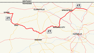
State Route 49 is a state highway in Tennessee. The route forms a broad southern arc that passes through the rural Middle Tennessee towns of Dover, Erin, Charlotte, Ashland City, Pleasant View, and Springfield.
State Route 16 is a state highway in the U.S. state of Tennessee. Its southern terminus is at the Alabama State Line, where it continues as State Route 79 in Alabama. From there, it continues to Winchester, where it becomes unsigned in a concurrency with U.S. Route 41A. This concurrency lasts until its northern terminus in Williamson County, at a junction with U.S. Route 31A.
State Route 77 (SR 77), is an east–west state highway in the U.S. state of Tennessee. The 84.86-mile-long (136.57 km) route traverses the flat farmland of West Tennessee.
State Route 195 is a 7.6 mile long east-west state highway in Fayette County, Tennessee. It connects Macon with Somerville, as well as providing access to Fayette County Airport.
