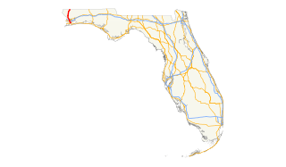
State Road 21 (SR 21) runs mostly in a southwest-to-northeast direction in the US state of Florida from McMeekin to Jacksonville. It is also known as Blanding Boulevard for much of its length.

State Route 161 is a primary state highway in and near Richmond, Virginia, United States. It extends from an interchange with Interstate 95 in the independent city of Richmond north to an intersection with U.S. Route 1 in the Lakeside area of central Henrico County.
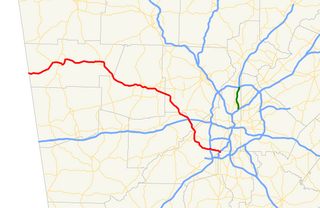
State Route 6 (SR 6) is a 72.1-mile-long (116.0 km) state highway that travels northwest-to-southeast in the U.S. state of Georgia. It is known as Jimmy Lee Smith Parkway, Jimmy Campbell Parkway, Nathan Dean Parkway, and Wendy Bagwell Parkway in Paulding County; C.H. James Parkway in Cobb County; Thornton Road in Douglas County; and Camp Creek Parkway and honorarily as Tuskegee Airmen Parkway in Fulton and Clayton counties. It begins at the Alabama state line, where it is concurrent with US 278. Here, US 278 enters Alabama, concurrent with the unsigned state highway SR 74. Its eastern terminus is at an interchange with Interstate 85 (I-85) west of the Hartsfield–Jackson Atlanta International Airport.
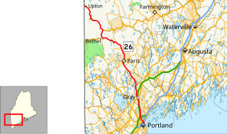
State Route 26 (abbreviated SR 26) is part of Maine's system of numbered state highways. It is a major regional route running for 96.7 miles (155.6 km) from downtown Portland to the New Hampshire border near Upton, where it continues as New Hampshire Route 26. It is a multi-state route along with NH 26 and its short extension into Vermont.
State Route 22 is a 172.8-mile long (278.1 km) south-to-north state highway in the western part of Tennessee, United States. It begins at the Mississippi state line in McNairy County, where the roadway continues as Mississippi Highway 2. It ends at the Kentucky state line in Lake County, when it crosses into the Kentucky Bend, a detached portion of Fulton County, Kentucky.

State Route 68 (SR-68) is a state highway in the U.S. state of Utah. It is a major thoroughfare throughout the Wasatch Front as it runs north–south for 70.832 miles (113.993 km), linking US-6 near Elberta to US-89 in Woods Cross. The route intersects several major freeways and highways in the Salt Lake City metropolitan area including I-215, I-80, and I-15. The route is more commonly referred to as Redwood Road, after the street it is routed along throughout Salt Lake County. The highway is also routed for a short distance along 500 South and 200 West in Bountiful and Camp Williams Road in Utah County. The route is a surface street for its entire length.
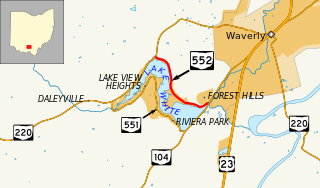
State Route 552 is an east-west state highway in southern Ohio. The western terminus of the route is at SR 220 about two and a half miles (4.0 km) west of Waverly. Its eastern terminus is at SR 104 nearly two miles (3.2 km) southwest of Waverly.

State Route 39 is a 118-mile-long (190 km) state highway that travels south-to-north through portions of Seminole, Miller, Early, Clay, Quitman, and Stewart counties in the southwestern part of the U.S. state of Georgia. The route proceeds north from its southern terminus along the shore of Lake Seminole in southern Seminole County to a point just southwest of Omaha, where it travels in an easterly direction until it meets its northern terminus, an intersection with US 27/SR 1 in the unincorporated community of Louvale Station.
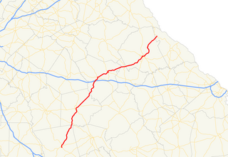
State Route 44 (SR 44) is a 94.2-mile-long (151.6 km) state highway that runs southwest-to-northeast through portions of Jones, Putnam, Greene, Taliaferro, Wilkes, and Lincoln counties in the central and east-central parts of the U.S. state of Georgia. The route connects Gray with the central portion of Lincoln County, northwest of Lincolnton.
U.S. Route 29 in the State of Florida is the westernmost south-to-north U.S. route in the state. It runs 43.6 miles (70.2 km) from downtown Pensacola north to the Alabama state line entirely within Escambia County. US 29 runs as a four-lane highway through much of the panhandle, becoming six lanes through and near several towns. The highway's hidden state road designation is entirely State Road 95.
U.S. Route 41 (US 41) in the U.S. state of Florida is a north–south United States Highway. It runs 479 miles (771 km) from Miami in South Florida northwest to the Georgia border north of the Lake City area. Within the state, US 41 is paralleled by Interstate 75 (I-75) all the way from Miami to Georgia, and I-75 has largely supplanted US 41 as a major highway.
State Route 157 is a short secondary highway in northern Obion County, Tennessee.
State Route 62, also known as Monsanto Road, is a 2.443-mile-long (3.932 km) state highway near Guntersville in Marshall County. The highway heads east from lakeside homes and marinas along Lake Guntersville to SR 227 near Guntersville.

Pennsylvania Route 415 is a 10.035-mile-long (16.150 km) state highway located in Luzerne and Wyoming counties in Pennsylvania. The southern terminus is at Route 309 in Dallas while the northern terminus is at Route 29 near Harveys Lake in the community of Ruggles. A rare feature of this road is that the right-of-way splits in Harveys Lake, where the State Route 0415 alignment heads along the western side of Harveys Lake, while State Route 1415 heads along the eastern side. The two routes merge several miles north.

U.S. Route 129 (US 129) is a 375-mile-long (604 km) U.S. Highway in the U.S. state of Georgia. It travels south-to-north from the Florida state line, south of Statenville, to the North Carolina state line, northwest of Blairsville.
State Route 21 is a two lane highway that runs from the Mississippi River west of Tiptonville, Tennessee to the Kentucky state line north of Union City. This road provides access to Reelfoot Lake State Park.
There are 34 routes assigned to the "S" zone of the California Route Marker Program, which designates county routes in California. The "S" zone includes county highways in Imperial, Orange, Riverside, San Diego, and Santa Barbara counties.
State Route 304 is a state highway in Meigs and Roane counties in the eastern portion of the U.S. state of Tennessee. It connects Decatur to Kingston via SR 68 and Ten Mile. It provides access to many marinas and lakeside homes along Watts Bar Lake.
State Route 363, also known as Indian Creek Road, is a 6.0-mile-long (9.7 km) east-west mile long state highway in Jefferson County, Tennessee. It provides access to lakeside homes and marinas along the south shore of Douglas Lake.
