The Huguenots were a religious group of French Protestants who held to the Reformed (Calvinist) tradition of Protestantism. The term, which may be derived from the name of a Swiss political leader, the Genevan burgomaster Besançon Hugues (1491–1532), was in common use by the mid-16th century. Huguenot was frequently used in reference to those of the Reformed Church of France from the time of the Protestant Reformation. By contrast, the Protestant populations of eastern France, in Alsace, Moselle, and Montbéliard, were mainly Lutherans.

Wardour Street is a street in Soho, City of Westminster, London. It is a one-way street that runs north from Leicester Square, through Chinatown, across Shaftesbury Avenue to Oxford Street. Throughout the 20th century the West End street became a centre for the British film industry and the popular music scene.

Spitalfields is an area in London, England and is located in the London Borough of Tower Hamlets. It is in East London and situated in the East End. Spitalfields is formed around Commercial Street and Brick Lane. It has several markets, including Spitalfields Market, the historic Old Spitalfields Market, Brick Lane Market and Petticoat Lane Market. The area has a long attracted migrants from overseas, including many Jews, whose presence gained the area the 19th century nickname of Little Jerusalem.

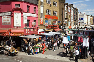
Brick Lane is a famous street in the East End of London, in the borough of Tower Hamlets. It runs from Swanfield Street in Bethnal Green in the north, crosses the Bethnal Green Road before reaching the busiest, most commercially active part which runs through Spitalfields, or along its eastern edge. Brick Lane's southern end is connected to Whitechapel High Street by a short extension called Osborn Street.
Petticoat Lane Market is a fashion and clothing market in Spitalfields, London. It consists of two adjacent street markets. Wentworth Street Market is open six days a week and Middlesex Street Market is open on Sunday only.

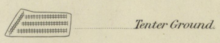
Tenterhooks or tenter hooks are hooked nails in a device called a tenter. Tenters were wooden frames which were used as far back as the 14th century in the process of making woollen cloth. They are now superseded by stenter pins.

Christ Church Spitalfields is an Anglican church built between 1714 and 1729 to a design by Nicholas Hawksmoor. On Commercial Street in the East End and in today's Central London it is in the London Borough of Tower Hamlets, on its western border facing the City of London, it was one of the first of the so-called "Commissioners' Churches" built for the Commission for Building Fifty New Churches, which had been established by an act of parliament in 1711.
Chuts is the name applied to Jews who immigrated to London from the Netherlands in the mid-Victorian era (1850s–1860s). They typically came from the cities of Amsterdam and Rotterdam, and brought to London their trades: most notably those of cigar-, cap-, and slipper-making, and as small-time ship chandlers.
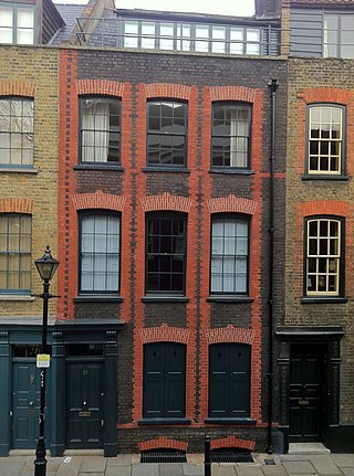
Fournier Street, formerly Church Street, is a street of 18th-century houses in Spitalfields in the East End of London. It is in the London Borough of Tower Hamlets and runs between Commercial Street and Brick Lane. The street is named after a man of Huguenot extraction, George Fournier.
Huguenot weavers were French silk weavers of the Calvinist faith. They came from major silk-weaving cities in southern France, such as Lyon and Tours. They fled from religious persecution, migrating from mainland Europe to Britain around the time of Revocation of the Edict of Nantes, 1685.

The Museum of Immigration and Diversity is a museum at 19 Princelet Street in Spitalfields, in the London Borough of Tower Hamlets, England. The Grade II* listed building in which the museum is located was a house built in 1719 for the Huguenot silk merchant Peter Abraham Ogier.

Great Titchfield Street is a street in the West End of London. It runs north from Oxford Street to Greenwell Street, just short of the busy A501 Marylebone Road and Euston Road. It lies within the informally designated London area of Fitzrovia. In administrative terms it is in the City of Westminster. It lies within their designated East Marylebone Conservation Area in the former Metropolitan Borough of St Marylebone.

Brick Lane Mosque or Brick Lane Jamme Masjid, formerly known as the London Jamme Masjid, is a Muslim place of worship in Central London and is in the East End of London.

Bolsover Street is in the Parish of St Marylebone in London's West End. In administrative terms it lies within the City of Westminster's West End Ward and is partly in the Harley Street Conservation Area whilst also sitting on the edges of the Regents Park and East Marylebone Conservation Areas.

The Huguenot Burial Site is a former burial ground for Huguenots in Wandsworth, London. It was in use from 1687 to 1854. The burial site is located between East Hill and Huguenot Place in the London Borough of Wandsworth. It is located next to St Mary Magdalen Roman Catholic Church.

In 1746, the French-born British surveyor and cartographer John Rocque produced two maps of London and the surrounding area. The better known of these has the full name A Plan of the Cities of London and Westminster, and Borough of Southwark: it is a map of Georgian London to a scale of 26 inches to a mile, surveyed by John Rocque, engraved by John Pine, and published in 1746. It consists of 24 sheets and measures 3.84 m × 2.01 m. Taking nearly ten years to survey, engrave and publish, it has been described as "a magnificent example of cartography ... one of the greatest and most handsome plans of any city".
Brick Lane is a 2006 British documentary directed and produced by Minoo Bhatia. The documentary is about the personal stories and journeys of people who have made the street Brick Lane their home, how these different groups have shaped the town and the changing cultural markers that define the area. It was broadcast by BBC Two on 25 March 2006.

Potters Fields Park is a small public park situated in the London Borough of Southwark in London, England. The park is located immediately south-west of Tower Bridge and immediately south-east of City Hall, London. It is frequently used for food festivals and other events.
Bay was a napped coarse woolen fabric, not technically considered cloth, introduced to England by Flemish immigrants in the 16th century. It was produced in Essex at Colchester and Bocking, and also in various towns in the West of England. Production continued until the 19th century. Bays were made into linings for furniture, hangings, curtains, bed surroundings, and cloaks.

The history of the Huguenots in Kent dates back to the mid 1500s.