
Zaragoza metro station is a station of the Mexico City Metro in Venustiano Carranza, Mexico City. It is an underground station with two side platforms served by Line 1 between Gómez Farías and Pantitlán stations. It serves the colonias (neighborhoods) of 4 Árboles and Puebla. It lies below the Calzada Ignacio Zaragoza from which it receives its name, which in turn is named after Ignacio Zaragoza, the Secretary of War and Navy during the Battle of Puebla. The station's pictogram features a silhouette of the nearby equestrian statue that honors him.

Boulevard Puerto Aéreo metro station is a station of the Mexico City Metro in Venustiano Carranza, Mexico City. It is an underground station with two side platforms served by Line 1 between Balbuena and Gómez Farías stations. It serves the colonias (neighborhoods) of Moctezuma, Santa Cruz Aviación, and Valentín Gómez Farías. It lies below Puerto Aéreo Boulevard, from which it receives its name, and it is near Calzada Ignacio Zaragoza. The station's pictogram features a silhouette of an air vent below a road bridge, in reference to a landmark found at the intersection of both avenues. The station is partially accessible to people with disabilities.

Indios Verdes metro station is a station of the Mexico City Metro along Insurgentes Norte Avenue in the colonias (neighborhoods) of Residencial Zacatenco and Santa Isabel Tola, in Gustavo A. Madero, Mexico City. It is an at-grade station with two island platforms that serves as the northern terminus of Line 3. It is followed by Deportivo 18 de Marzo station. The station and its surrounding area are named this way because of the verdigris statues of Itzcoatl and Ahuitzotl, both Aztec rulers. They are located in Mestizaje Park and are collectively known as the Monumento a los Indios Verdes; the silhouettes of the statues are depicted in the pictogram. The station was opened on 1 December 1979, on the first day of service between Indios Verdes and Hospital General stations.

Terminal Aérea metro station is a Mexico City Metro station next to the Mexico City International Airport in Venustiano Carranza, Mexico City. It is an underground station with two side platforms, served by Line 5, between Oceanía and Hangares stations. The station serves colonias (neighborhoods) of Peñón de los Baños and Moctezuma 2ª sección.

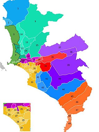
The Lima and Callao Metro is a rapid transit system that serves the cities of Lima and Callao, which make up the Lima metropolitan area. The existing metro lines currently link the district of Villa El Salvador in the south of Lima with San Juan de Lurigancho in the northeast of the city, as well as a 5km segment in the east of the metro area. Furthermore, there are four additional lines planned for the network.
The Rímac River is located in western Peru and is the most important source of potable water for the Lima and Callao Metropolitan Area. It belongs to the Pacific Slope, into which it flows after bathing the cities of Lima and Callao, together with the Chillón River, to the north, and the Lurín River, to the south. It is 204 km long and has a basin of 3,312 km², of which 2,237.2 km² is a humid basin. The basin has a total of 191 lagoons, of which only 89 have been studied. The river begins in the highlands of the Huarochirí Province in the Lima Region and its mouth is located in Callao, near Jorge Chávez International Airport.
The Lima Metropolitan Area is an area formed by the conurbation of the Peruvian provinces of Lima and Callao. It is the largest of the metropolitan areas of Peru, the seventh largest in the Americas, the fourth largest in Latin America, and among the thirty largest in the world. The conurbation process started to be evident in the 1980s.

San Martín de Porres (SMP) is a district in Lima, Peru, located in the north area of the city. It is bordered by the Chillón River, marks its natural border with Ventanilla and Puente Piedra on the north; Callao on the west; Los Olivos, Comas on the northeast; Rímac and Independencia districts on the east; the Rímac River marks its natural border with Lima District and Carmen de la Legua Reynoso on the south. It is the second most populated district of Lima metropolitan area and Peru.

Los Olivos is a district of the Lima Province in Peru. Is a District of the Cono Norte area in the city of Lima.

Independencia is a district of the Lima Province in Peru. It is located in the north area of the city.

Line 5, also known as the Yellow Line from its color on the system map, is a rapid transit line of the Mexico City Metro network. It travels 15.6 kilometers (9.7 mi) along the boroughs of Gustavo A. Madero, Cuauhtémoc and Venustiano Carranza in northern, northeastern and eastern Mexico City, serving thirteen stations. The line was inaugurated on 19 December 1981, going from Pantitlán to Consulado station. In 1982, the line was expanded twice, first from Consulado to La Raza station on 1 July, and later from La Raza to Politécnico station on 30 August.

Metropolitano is a bus rapid transit system serving the city of Lima, Peru. Its construction began in the year 2006.

The Mar de Grau is the official name for the body of water in the Pacific Ocean under the control of the South American country of Peru. This body of water extends in length approximately 3,079.50 km, from the parallel of the Boca de Capones in northern Peru to the parallel of the Punto Concordia and the parallel in front of the city of Tacna in southern Peru. In terms of width, the maritime zone extends from the Peruvian coast to 200 nautical miles into the Pacific Ocean.

Príncipe Pío is a multimodal train station in Madrid, Spain that services Madrid Metro's Line 6, Line 10, and Ramal; Cercanías Madrid's commuter rail lines C-1, C-7, and C-10; and city buses and intercity and long-distance coaches. It is located next to the River Manzanares between the San Vicente roundabout and the streets of Cuesta de San Vicente, Paseo de la Florida, and Paseo del Rey in the district of Moncloa-Aravaca. It is one of the busiest stations in the Madrid Metro and Cercanías systems.
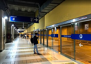
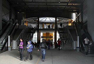
Estación Central is the central station of the Metropolitano bus system in Lima, Peru. It is located under the Paseo de los Héroes Navales, between the Plaza Grau and Bolivia/Roosevelt avenues, where the system path's bifurcation begins.
Terminal Matellini, also known as Estación Terminal Sur, is the southern terminal of the Metropolitano bus system in Lima, Peru. It is located in Chorrillos District.

Estadio Nacional is a station of the Metropolitano bus system in Lima, Peru. It is located east of the National Stadium of Peru and the Park of the Reserve, receiving its name from the former, between the districts of La Victoria and Lima's Santa Beatriz neighbourhood.

Comunidad Andina-Aramburú, formerly known as Aramburú, is a station of the Metropolitano bus system in Lima, Peru. It is located at the intersection of Paseo de la República and Andrés Aramburú Avenue, next to the Headquarters of the Andean Community. It received its current name in 2023 after a successful proposal by the Ministry of Foreign Affairs.

Andrés Reyes is a station of the Metropolitano bus system in Lima, Peru. It is located at the intersection of Paseo de la República and jirón Andrés Reyes in San Isidro District. The station was built to alleviate the load taken by neighbouring Canaval y Moreyra and Javier Prado stations.
Colmena is a station of the Metropolitano bus system in Lima, Peru. It is located at the intersection of Nicolás de Piérola (Colmena) avenue and Jirón Lampa, next to Democracy Square.
