Teufelkap

Last updated
Teufelkap
Teufels-Kap
Devil Cape
Greenland edcp location map.svg
Red pog.svg
Location Djævleøen
Coordinates 76°22′55″N20°10′49″W / 76.38194°N 20.18028°W / 76.38194; -20.18028 Coordinates: 76°22′55″N20°10′49″W / 76.38194°N 20.18028°W / 76.38194; -20.18028
Offshore water bodies Dove Bay
Greenland Sea
Elevation732 m (2,402 ft)
Area Arctic

Teufelkap (German : Teufels-Kap), meaning "Devil Cape", is a headland in King Frederick VIII Land, Northeast Greenland. Administratively it is part of the Northeast Greenland National Park. [1]

German language West Germanic language

German is a West Germanic language that is mainly spoken in Central Europe. It is the most widely spoken and official or co-official language in Germany, Austria, Switzerland, South Tyrol in Italy, the German-speaking Community of Belgium and Liechtenstein. It is one of the three official languages of Luxembourg and a co-official language in the Opole Voivodeship in Poland. The languages that are most similar to the German are the other members of the West Germanic language branch, including Afrikaans, Dutch, English, the Frisian languages, Low German/Low Saxon, Luxembourgish, and Yiddish. There are strong similarities in vocabulary with Danish, Norwegian and Swedish, although those belong to the North Germanic group. German is the second most widely spoken Germanic language, after English.

King Frederick VIII Land Region in Greenland

King Frederick VIII Land is a major geographic division of northeastern Greenland. It extends above the Arctic Circle from 76°N to 81°N in a N/S direction along the coast of the Greenland Sea.

Greenland autonomous territory within the Kingdom of Denmark

Greenland is the world's largest island, located between the Arctic and Atlantic oceans, east of the Canadian Arctic Archipelago. It is an autonomous territory within the Kingdom of Denmark. Though physiographically a part of the continent of North America, Greenland has been politically and culturally associated with Europe for more than a millennium. The majority of its residents are Inuit, whose ancestors migrated from Alaska through Northern Canada, gradually settling across the island by the 13th century. Nowadays the population is largely concentrated on the southwest coast of the island while the rest of the island is sparsely populated. Greenland is divided into five municipalities — Sermersooq, Kujalleq, Qeqertalik, Qeqqata, and Avannaata. It has two unincorporated areas — the Northeast Greenland National Park and the Thule Air Base. The last one, even if under Danish control, is administered by the United States Air Force.

Contents

Its cliffs are a home for seabird colonies. [2]

History

Teufelkap was named in 1870 by Carl Koldewey (1837–1908). [3] The steep headland with a dark red hue looked frightening in the fog when it was first seen by members of the Second German North Polar Expedition in March 1870. Later visitors of the area confirmed that the name chosen by the German explorers was suitable to refer to the sinister-looking headland. [4]

Carl Koldewey German explorer

Carl Christian Koldewey was a German Arctic explorer. He led both German North Polar Expeditions.

Geography

Teufelkap is located in Dove Bay at the eastern end of Djævleøen. It is a conspicuous landmark. The entrance of the A. Stelling Sound lies to the SW around the cape. [5]

Dove Bay bay in Greenland

Dove Bay is a bay in King Frederick VIII Land, northeastern Greenland. It is part of the Northeast Greenland National Park area.

Djævleøen island in Greenland

Djævleøen, meaning "Devil Island", is an uninhabited island of King Frederick VIII Land, NE Greenland.

Map of Northeastern Greenland. Operational Navigation Chart B-9, 1st edition.jpg
Map of Northeastern Greenland.

Related Research Articles

Store Koldewey island

Store Koldewey, meaning 'Big Koldewey', is the largest of the Koldewey Islands in King Frederick VIII Land, northeastern Greenland.

German North Polar Expedition series of arctic German expeditions

The German North Polar Expeditions were a short series of mid-19th century German expeditions to the Arctic. The aim was to explore the North Pole region and to brand the newly united, Prussian-led German Empire as a great power. In 1866, German geographer August Petermann wrote a pamphlet strongly advocating German participation in the international quest for the North Pole, which stimulated a German expedition.

Wollaston Foreland peninsula in Greenland

Wollaston Foreland is a peninsula in King Christian X Land, East Greenland. Administratively it belongs to the NE Greenland National Park area.

Sabine Island island in Greenland

Sabine Island is an island to the northeast of Wollaston Foreland, previously known as Inner Pendulum Island. It is in the Northeast Greenland National Park area.

Germania Land peninsula in Greenland

Germania Land or Germanialand is a peninsula in northeastern Greenland. Despite the high latitude it is largely unglaciated.

Tunumiit

Tunumiit are Greenlandic Inuit from Tunu, the eastern part of Greenland. The Tunummiit live now mainly in Tasiilaq and Ittoqqortoormiit and are a part of the Arctic people known collectively as the Inuit. The singular for Tunumiit is Tunumiu.

Iluileq island in Greenland

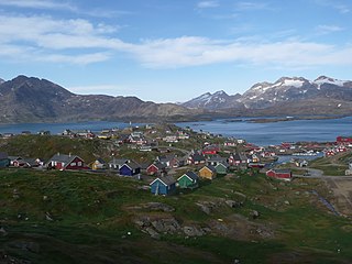
Iluileq is an uninhabited island in the Kujalleq municipality in southern Greenland.

Payer Peak mountain in Greenland

Payer Peak, is a mountain in King Christian X Land, Northeast Greenland. Administratively it is part of the Northeast Greenland National Park zone.

Denmark expedition 1906–1908 expedition to Greenland

The Denmark expedition, also known as Denmark Expedition to Greenland's Northeast Coast, and as the Danmark Expedition after the ship, was an expedition to the northeast of Greenland in 1906–1908.

Cape Walløe cape in Greenland

Cape Walløe, also known as Kangeq and Kangerssiuasik, is a headland in the North Atlantic Ocean, southeast Greenland, Kujalleq municipality.

Cape Discord peninsula in Kujalleq, Greenland

Cape Discord, also known as Kangeq, is a headland in the North Atlantic Ocean, southeast Greenland, Kujalleq municipality.

Peters Bay bay of the Greenland Sea in King Christian X Land, Greenland

Peters Bay is a bay of the Greenland Sea in King Christian X Land, Greenland. Administratively it belongs to the NE Greenland National Park area.

Cape Simpson (Greenland)

Cape Simpson is a headland in the Greenland Sea, Northeast Greenland. Administratively it is part of the NE Greenland National Park.

Mackenzie Bay bay in Northeast Greenland National Park, Greenland

Mackenzie Bay is a bay of the Greenland Sea in King Christian X Land, Greenland. Administratively it belongs to the NE Greenland National Park area.

Young Sound sound in Greenland

Young Sound is a marine channel with a fjord structure in King Christian X Land, East Greenland. Administratively it is part of the Northeast Greenland National Park zone.

Lindeman Fjord

Lindeman Fjord is a fjord in King Christian X Land, East Greenland. Administratively it is part of the Northeast Greenland National Park zone.

Cape Bismarck peninsula in Northeast Greenland National Park, Greenland

Cape Bismarck is a headland in King Frederick VIII Land, Northeast Greenland. Administratively it is part of the Northeast Greenland National Park.

References

  1. Den grønlandske Lods - Sejladsanvisninger Østgrønland
  2. Amdrup, G. 1913: Report on the Danmark Expedition to the northeast coast of Greenland 1906–08. Meddelelser om Grønland 41(1), 270 pp
  3. Karl Christian Koldewey, Die Zweite Deutsche Nordpolarfahrt: Unter Führung des Kapitän Koldewey. 1869 - 1870
  4. "Catalogue of place names in northern East Greenland". Geological Survey of Denmark. Retrieved 9 July 2019.
  5. "Teufelkap". Mapcarta. Retrieved 11 July 2019.