
Puka-Puka is a small coral atoll in the north-eastern Tuamotu Archipelago, sometimes included as a member of the Disappointment Islands. This atoll is quite isolated, the nearest land being Fakahina, 182 km to the southwest.

Punaʻauia is a commune in the suburbs of Papeʻete in French Polynesia, an overseas territory of France in the Pacific Ocean. Punaʻauia is located on the island of Tahiti, in the administrative subdivision of the Windward Islands, themselves part of the Society Islands. In the late 1890s, the French painter Paul Gauguin lived in Punaʻauia. Here he painted his masterpiece Where Do We Come From? What Are We? Where Are We Going?. The commune borders Faʻaʻā on the north and Pāʻea on the south.

Pīra'e[pi.ra.e] is a commune in the suburbs of Pape'ete in French Polynesia, an overseas territory of France in the Pacific Ocean. Pīra'e is located on the island of Tahiti, in the administrative subdivision of the Windward Islands, themselves part of the Society Islands. It borders Pape'ete in the west and Arue in the east. At the 2017 census it had a population of 14,209. The Stade Pater Te Hono Nui is a stadium located in the commune.

Arue is a commune in the suburbs of Papeete in French Polynesia, an overseas territory of France in the Pacific Ocean. Arue is located on the island of Tahiti, in the administrative subdivision of the Windward Islands, themselves part of the Society Islands. At the 2017 census it had a population of 10,243.

In French Polynesia, there are two levels of administrative divisions: five administrative subdivisions and 48 communes. Many of the communes are further subdivided into communes associées. The breakdown into administrative subdivisions was as a result of the law #71-1028, dated December 24, 1971. The compositions of the administrative subdivisions and the communes were defined in the decrees #72-408 and #72-407 of May 17, 1972, respectively. These subdivisions were confirmed in the decree #2005-1611 of December 20, 2005. Below are several lists of the divisions, according to different sorting schemes.

Paparā is a commune of French Polynesia, an overseas territory of France in the Pacific Ocean. Paparā is located on the island of Tahiti, in the administrative subdivision of the Windward Islands, themselves part of the Society Islands. At the 2017 census it had a population of 11,680.

Hitia'a O Te Ra is a commune of French Polynesia, an overseas territory of France in the Pacific Ocean. The commune of Hitia'a O Te Ra is located on the island of Tahiti, in the administrative subdivision of the Windward Islands, themselves part of the Society Islands. At the 2017 census it had a population of 10,033.
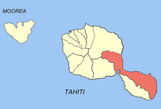
Ta'iarapu-Est is a commune of French Polynesia, an overseas territory of France in the Pacific Ocean. The commune of Tai'arapu-Est is located on the island of Tahiti, in the administrative subdivision of the Windward Islands, themselves part of the Society Islands. At the 2017 census it had a population of 12,701.
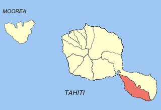
Taiarapu-Ouest is a commune of French Polynesia, an overseas territory of France in the Pacific Ocean. The commune of Tai'arapu-Ouest is located on the island of Tahiti, in the administrative subdivision of the Windward Islands, themselves part of the Society Islands. At the 2017 census it had a population of 8,078.
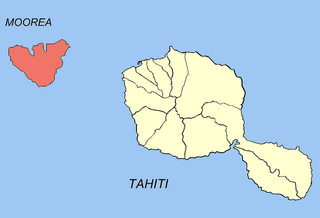
Moʻorea-Maiʻao is a commune of French Polynesia, an overseas territory of France in the Pacific Ocean. The commune is in the administrative subdivision of the Windward Islands. At the 2017 census it had a population of 17,816.

Raivavae is one of the Austral Islands in French Polynesia. Its total land area including offshore islets is 17.9 km2 (6.9 sq mi). At the 2017 census, it had a population of 903. The island is of volcanic origin, and rises to 437 metres (1,434 ft) elevation at Mont Hiro.
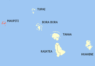
Maupiti is a commune of French Polynesia, an overseas territory of France in the Pacific Ocean. The commune is in the administrative subdivision of the Leeward Islands.

Arutua, or Ngaru-atua is an atoll in the Tuamotu group in French Polynesia. It is located 40 km SW of Rangiroa. The closest land is Apataki Atoll, only 16 km to the East.

Nuku-Hiva is a commune of French Polynesia, an overseas territory of France in the Pacific Ocean. The commune is in the administrative subdivision of the Marquesas Islands. Its population was 2,951 at the 2017 census.

Hiva-Oa is a commune of French Polynesia, an overseas territory of France in the Pacific Ocean. The commune is in the administrative subdivision of the Marquesas Islands. Its population was 2,243 at the 2017 census.

Rangiroa is a commune of French Polynesia in the archipelago of the Tuamotu Islands. The commune includes four islands: Rangiroa, Tikehau, Mataiva and Makatea. The chef-lieu is the village Tiputa.
Fakarava is a commune of French Polynesia in the archipelago of the Tuamotu Islands. The commune is in the administrative subdivision of the Îles Tuamotu-Gambier. The commune includes seven islands. The chef-lieu is the village Rotoava.

Gambier is a commune of French Polynesia in the administrative subdivision of the Tuamotu-Gambier Islands. The commune includes the Gambier Islands as well as several atolls in the Tuamotu Archipelago. All the Tuamotu atolls belonging to the commune are uninhabited except for Marutea Sud, and are sometimes mistakenly included among the Gambier Islands themselves. The commune population was 1,535 at the 2017 census. Its total land area is 45.97 km2.

Bora-Bora is a commune of French Polynesia, an overseas territory of France in the Pacific Ocean. The commune is in the administrative subdivision of the Leeward Islands. Its population was 10,549 at the 2017 census.
Mataiea is an associated commune on the island of Tahiti, in French Polynesia. It is the administrative centre of the commune of Teva I Uta.

