Baragoi is a market town in Kenya, lying north of Maralal and east of the Suguta Valley. It is located in Samburu County. The entire Baragoi division has a population of nearly 20,000 comprising mostly people from the Samburu and Turkana tribes.
Bór is a former PKP railway station in Hel, Poland. The station was used for military base service.

Kardámaina or Kardámena, is a small Greek town 7 km from Kos Island International Airport at Antimacheia, situated mid-way along the south coast of the island of Kos. It lies in the municipal unit of Irakleides, in the Dodecanese. Once a small fishing village, it has been a popular summer destination for the past two decades, offering pubs, restaurants, bars, night clubs and watersports facilities. According to the 2011 census, there were 1,650 inhabitants census and a land area of 35.150 km². Between June and September the town population can triple due to tourist influx.

Obid is a village and municipality in the Nové Zámky District in the Nitra Region of south-west Slovakia.
Seenplatte is a Verwaltungsgemeinschaft in the district Saale-Orla-Kreis, in Thuringia, Germany. The seat of the Verwaltungsgemeinschaft is in Oettersdorf.

Lubieszów is a village in the administrative district of Gmina Nowa Sól, within Nowa Sól County, Lubusz Voivodeship, in western Poland. It lies approximately 5 kilometres (3 mi) west of Nowa Sól and 21 km (13 mi) south-east of Zielona Góra.
Jędrzejki is a village in the administrative district of Gmina Kalinowo, within Ełk County, Warmian-Masurian Voivodeship, in northern Poland. It lies approximately 11 kilometres (7 mi) south of Kalinowo, 20 km (12 mi) east of Ełk, and 142 km (88 mi) east of the regional capital Olsztyn.
Snopki is a village in the administrative district of Gmina Pisz, within Pisz County, Warmian-Masurian Voivodeship, in northern Poland. It lies approximately 4 kilometres (2 mi) north of Pisz and 86 km (53 mi) east of the regional capital Olsztyn.
Siniechowo is a village in the administrative district of Gmina Wolin, within Kamień County, West Pomeranian Voivodeship, in north-western Poland. It lies approximately 7 kilometres (4 mi) south of Wolin, 23 km (14 mi) south-west of Kamień Pomorski, and 41 km (25 mi) north of the regional capital Szczecin.

The Arys is a river of southern Kazakhstan and a tributary of the Syr Darya. The river is 378 kilometres (235 mi) long, covering a basin area of 14,900 square kilometres (5,800 sq mi).

Dana Island is a small Mediterranean island of Turkey.

Yehualtepec (municipality) is a town and municipality in Puebla in south-eastern Mexico.
Béni Khiar is a town and commune in the Nabeul Governorate, Tunisia. As of 2004 it had a population of 16,992.
Takelsa is a town and commune in the Nabeul Governorate, Tunisia. As of 2004 it had a population of 20,169.
Dematti is a village in Belgaum district in the southern state of Karnataka, India.
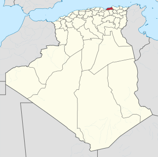
Sidi Lazreg is a town and commune in Relizane Province, Algeria.
Uzunkale, Manavgat is a village in the District of Manavgat, Antalya Province, Turkey.
Chapayevka is the name of several rural localities in Russia.
Maraand is a Syrian village located in Bidama Nahiyah in Jisr al-Shughur District, Idlib. According to the Syria Central Bureau of Statistics (CBS), Maraand had a population of 734 in the 2004 census.