
Andhra Pradesh is a state in the southern coastal region of India. It is the seventh-largest state with an area of 162,970 km2 (62,920 sq mi) and the tenth-most populous state with 49,577,103 inhabitants. It has shared borders with Chhattisgarh, Odisha, Karnataka, Tamil Nadu, Telangana and the Bay of Bengal. It has the second-longest coastline in India at about 974 km (605 mi). After existence as Andhra State and unified Andhra Pradesh, the state took its present form on 2 June 2014, when the new state of Telangana was formed through bifurcation. Amaravati is the capital of the state, with the largest city being Visakhapatnam. Water sharing disputes and asset division with Telangana are not yet resolved. Telugu, one of the classical languages of India used by the majority of people, is the first official language.

East Godavari is a district in the Coastal Andhra region of Andhra Pradesh, India. Its district headquarters is at Rajamahendravaram.

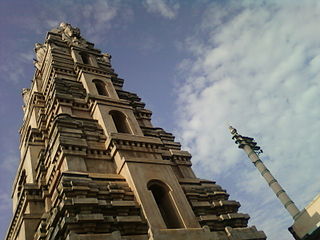
Rajahmundry, officially known as Rajamahendravaram, is a city in the Indian state of Andhra Pradesh and district headquarters of East Godavari district. It is the fifth most populated city in the state. During British rule, the district of Rajahmundry was created in the Madras Presidency in 1823. It was reorganised in 1859 and bifurcated into the Godavari and Krishna districts. Rajahmundry was the headquarters of Godavari district, which was further bifurcated into East Godavari and West Godavari districts in 1925. When the Godavari district was bifurcated, Kakinada became the headquarters of East Godavari and Eluru the headquarters of West Godavari. It is administered under Rajahmundry revenue division of the East Godavari district. The city is known for its floriculture, history, culture, agriculture, economy, tourism, and its heritage. It is known as the "Cultural Capital of Andhra Pradesh".

The West Godavari district is a coastal district in the Indian state of Andhra Pradesh with an administrative headquarters in Bhimavaram. As of the 2011 Census of India, the district has an area of 2,178 km2 (841 sq mi) and a population of 1,779,935. It is bounded by the Krishna district and Bay of Bengal to the south, East Godavari district to the east, and Eluru district, Kolleru Lake and Upputeru Drain to the northwest.
Kakinada is the sixth largest city of the Indian state of Andhra Pradesh and serves as the district headquarters of the Kakinada District. It lies on the coast of the Bay of Bengal. J.N.T.U. College of Engineering Kakinada, established in 1946, is the oldest and popular Government college in the state of Andhra Pradesh. The First Polytechnic college of Andhra Pradesh, Andhra Polytechnic was established here in 1946. It was also the origin point of Buckingham Canal where goods used to be transported by boats during the British rule. It was once home for Asia's largest sea port. Many people from the city migrated from this sea port to countries like Burma, Mauritius, Fiji and various southeast Asian countries to work there as workers where they were called as Coringas.

Eluru is a city and the district headquarters of Eluru district in the Indian state of Andhra Pradesh. It is one of the 14 municipal corporations in the state and the mandal headquarters of Eluru mandal in the Eluru revenue division. The city is on the Tammileru river. The city is well known for its wool-pile carpets and hand woven products. As of 2011 Census of India, the city had a population of 214,414. Its history dates back to the second century CE.

Kovvur is a town in the East Godavari district of the Indian state of Andhra Pradesh. It is a municipality and the mandal headquarters of Kovvur mandal in Kovvur revenue division.

Khammam district is a district in the eastern region of the Indian state of Telangana. The city of Khammam is the district headquarters. The district shares boundaries with Suryapet, Mahabubabad, Bhadradri districts and with Eluru and NTR districts.

Palakollu is a city and the administrative headquarters of Palakollu Mandal in Narasapuram revenue division in West Godavari district of the Indian state of Andhra Pradesh. Palakollu is situated in Coastal Andhra region of the state. It occupies 4.685 square kilometres (1.809 sq mi). As of 2011 census, it had a population of about 61,284 and a Metro population of about 81,199. Palakollu Municipality merged five Grama panchayats of Seven village's on 7 January 2020. The Seven Villages' had a population of 42,932 as of 2011 Census. It around occupies 20.08 square kilometres (7.75 sq mi) and after merged palakollu municipality, It around occupies 24.68 square kilometres (9.53 sq mi) with 35 election wards it is total population of 1,04,216 and making it the third most populous urban area in West Godavari District in Andhra Pradesh. It is a part of Eluru Urban Development Authority.

Tanuku is a City in West Godavari district of the Indian state of Andhra Pradesh. It is the mandal headquarters of Tanuku mandal. Tanuku is 3rd largest town in the West Godavari District after Bhimavaram,Tadepalligudem in terms of population. Tanuku is the Textile Hub of both West Godavari district and East Godavari district. There are a Significant number of Large scale and Small scale Spinning Mills

Rampachodavaram is a census town in Alluri Sitharama Raju district of the Indian state of Andhra Pradesh. It is located in Rampachodavaram mandal of Rampachodavaram revenue division. Rampachodavaram is known for its dense jungle and waterfalls which can be accessed by road transport only.

Gollaprolu is a town in Kakinada district of the Indian state of Andhra Pradesh. It is a Municipality in Gollaprolu mandal of Kakinada revenue division. Business is the main occupation of this town. The town also forms a part of Godavari Urban Development Authority.
Allavaram is a village in Allavaram mandal, Dr. B.R. Ambedkar Konaseema district in the state of Andhra Pradesh in India which comes under Amalapuram revenue division.
Bikkavolu is a village in East Godavari district in the state of Andhra Pradesh in India. The village is known for its famous Subrahmanya Swamy Temple.
Malikipuram is a town of Dr. B.R. Ambedkar Konaseema district in Andhra Pradesh, India. It is located in the Amalapuram revenue division.
Thallarevu Mandal is one of the 21 mandals in Kakinada district of Andhra Pradesh. As per census 2011, there are 13 villages.

Alluri Sitharama Raju district, also known as Alluri district and by its initials as ASR district, is a district in the Indian state of Andhra Pradesh. The headquarters of the district is located at Paderu. Named after Alluri Sitarama Raju, a revolutionary in the Indian independence movement who hailed from the region, the district was effective since 4 April 2022 and became one of the twenty-six districts in the state. The district is known for its scenery and lies in the Eastern Ghats.

Eluru district is a district in coastal Andhra Region in the Indian state of Andhra Pradesh. With Eluru as its administrative headquarters, it was proposed on 26 January 2022 to become one of the resultant twenty six districts in the state once a final notification is issued by the government of Andhra Pradesh. It is formed from Eluru revenue division and Jangareddygudem revenue division from West Godavari district and Nuzvid revenue division from Krishna district.

Dr. B. R. Ambedkar Konaseema district is one of the 26 districts in the Indian state of Andhra Pradesh. It is situated between the tributaries of the Godavari river in the Konaseema region of Coastal Andhra. It was carved out of East Godavari district on 4 April 2022 by the Government of Andhra Pradesh. Amalapuram is the district headquarters and the largest city in this district. The district shares boundaries with West Godavari, East Godavari and Kakinada districts.

Kakinada district is a district in the Coastal Andhra Region in the Indian state of Andhra Pradesh. With Kakinada as its administrative headquarters, it was proposed on 26 January 2022 to become one of the resultant twenty six districts in the state after the final notification has been issued on 4 April 2022 by the government of Andhra Pradesh. The district was formed from Kakinada and Peddapuram revenue divisions from East Godavari district. Incidentally, during earlier times, the region comprising towns Pithapuram, Kakinada and Peddapuram were referred as Polnaud or Prolunadu, which now roughly corresponds to the areas in this district.

