Related Research Articles

The Andaman Sea is a marginal sea of the northeastern Indian Ocean bounded by the coastlines of Myanmar and Thailand along the Gulf of Martaban and west side of the Malay Peninsula, and separated from the Bay of Bengal to its west by the Andaman Islands and the Nicobar Islands. Its southern end is at Breueh Island just north of Sumatra, with the Strait of Malacca further southeast.

Ayeyarwady Region is a region of Myanmar, occupying the delta region of the Ayeyarwady River. It is bordered by the Rakhine State to the northwest, the Bago Region to the north, Bago Region and Yangon Region to the east, and the Bay of Bengal to the south and west.
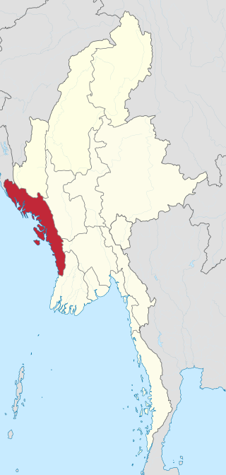
Rakhine State, formerly known as Arakan State, is a state in Myanmar (Burma). Situated on the western coast, it is bordered by Chin State to the north, Magway Region, Bago Region and Ayeyarwady Region to the east, the Bay of Bengal to the west and the Chittagong Division of Bangladesh to the northwest. It is located approximately between latitudes 17°30' north and 21°30' north and longitudes 92°10' east and 94°50' east. The Arakan Mountains or Rakhine Yoma separated Rakhine State from central Burma from North to South. Off the coast of Rakhine State there are some fairly large islands such as Ramree, Cheduba and Myingun. Rakhine State has an area of 36,762 square kilometres (14,194 sq mi) and its capital is Sittwe.

The Irrawaddy River is a river that flows from north to south through Myanmar (Burma). It is the country's largest river and most important commercial waterway. Originating from the confluence of the N'mai and Mali rivers, it flows relatively straight north–south before emptying through the Irrawaddy Delta in the Ayeyarwady Region into the Andaman Sea. Its drainage basin of about 404,200 square kilometres (156,100 sq mi) covers a large part of Burma. After Rudyard Kipling's poem, it is sometimes referred to as 'The Road to Mandalay'.
Pyapon is a town and seat of Pyapon District as well as Pyapon Township in the Ayeyarwady Region of Myanmar, along the Pyapon River, a distributary of the Ayeyarwady River. It is located about 15 kilometres (9.3 mi) inland from the Andaman Sea, about 75 miles (121 km) south of the previous capital, Yangon. It has a population of approximately 65,601 in 2021. It serves as a center for collecting rice from the surrounding agricultural areas, and is home to a diesel-run power plant, using equipment by the German firm Siemens.

Pyapon Township is a township of Pyapon District in the Ayeyarwady Region of Myanmar. The principal town and administrative seat of the district is Pyapon. The southern portion of the township includes Ahmar Subtownship, an unofficial division used by the Township for statistical and administrative ease.

Maubin District is a district in Ayeyarwady Division, Myanmar. It consists of 39 wards, 235 village groups and 1642 villages organized into four townships - Maubin, Pantanaw, Nyaungdon and Danuphyu. The district lies on a flat plain, cut by many streams, which is 1,362 feet above sea level. It has an area of 1651.49 square miles. The majority of the population are Burmese and Kayin nationals.

Pantanaw Township is a township of Maubin District in the Ayeyarwady Region of Myanmar. The township borders Kyonpyaw and Kyaunggon townships in Pathein District to its northwest and Einme and Wakema townships of Myaungmya District to its southwest. To the northeast, the township borders Danubyu Township and to its east it borders Maubin Township and Nyaungdon Township with the Ayeyarwaddy River forming the eastern boundary of the township. There are 4 urban wards, 52 village tracts totaling 449 villages in the township. The principal town of the township is Pantanaw.

Dedaye Township is a township of Pyapon District in the Ayeyarwady Region of Myanmar.
Dedaye Bridge, also known as the Ayeyarwady-Dedaye Bridge is a bridge linking Kungyangon Township in Yangon Division and Dedaye Township in Ayeyawady Division in southern Burma. It crosses the Ayeyawady River.

Ngapudaw Township or Ngaputaw Township is a township of Pathein District in the Ayeyarwady Region of Myanmar. The western portion of the township includes Ngayokaung Subtownship and the southern portion of the township includes Hainggyikyun Subtownship, both unofficial divisions used by the Township for statistical and administrative ease. The small village of Kyounku within Hainggyikyun Subtownship is the birthplace of former President of Myanmar Thein Sein.
Wakema Township is a township of Myaungmya District in central Ayeyarwady Region, Myanmar. The first Prime Minister of Burma, U Nu was born in the principal town, Wakema. The township is one of a few townships outside Kayin State with a majority Karen ethnic population.

Kyaukpyu Township is a township of Kyaukpyu District in the Rakhine State of Myanmar. The principal town is Kyaukpyu.

Thandwe Township is a township of Thandwe District in the Rakhine State of Myanmar. The principal town is Thandwe.
Dedaye is a town in the Ayeyarwady Region of south-west Myanmar. It is the seat of the Dedaye Township in the Pyapon District.

The Irrawaddy Delta or Ayeyarwady Delta lies in the Irrawaddy Division, the lowest expanse of land in Myanmar that fans out from the limit of tidal influence at Myan Aung to the Bay of Bengal and Andaman Sea, 290 kilometres (180 mi) to the south at the mouth of the Ayeyarwady River. The delta region is densely populated, and plays a dominant role in the cultivation of rice in rich alluvial soil as low as just 3 metres (9.8 ft) above sea level, although it also includes fishing communities in a vast area full of rivers and streams. On 2 May 2008, the delta suffered a major disaster, devastated by Cyclone Nargis, which reportedly killed at least 77,000 people with over 55,900 missing, and left about 2.5 million homeless.

Pakokku District is a district of the Magway Division in central Burma (Myanmar). It is situated in northern part of Magwe Region. The administrative centre is the city of Pakokku. Pakokku is a largest city of Magway Division. It is also the 13th largest city of Burma (Myanmar). The townships of Pakokku District are Pakokku, Yesagyo, Pauk, Seikphyu, Myaing, Htilin, Saw and Gangaw.

Nyaunglebin Township is a township situated in Nyaunglebin District, Bago Region of Myanmar.
Thein Swe is a Burmese politician and political prisoner who currently serves as an Amyotha Hluttaw member of parliament for Ayeyarwady Region' Constituency № 10. His father Min Swe is a former MP elect, having won a majority of 20,358 in the 1990 Burmese general election.
Wetthegan Wildlife Sanctuary is a protected area in Myanmar's Magway Region with an area of 4.4 km2 (1.7 sq mi) at an elevation of 60–90 m (200–300 ft). It was established in 1939. The sanctuary's 2 km2 (0.77 sq mi) lake and surrounding marshland provide habitat for waterfowl and freshwater fish. It is located about 16 km (9.9 mi) west of the Irrawaddy River close to the city of Salin in Salin Township. It receives south-west monsoon rains of about 723 mm (28.5 in) per year from June to August. It is one of four protected wetlands in the country.
References
- 1 2 Myanmar Information Management Unit (September 2019). Dedaye Myone Daethasaingyarachatlatmya https://themimu.info/sites/themimu.info/files/documents/TspProfiles_GAD_Dedaye_2019_MMR.pdf [Dedaye Township Regional Information](PDF) (Report). MIMU. Retrieved 23 February 2024.
- ↑ "Thandi River". Chinci. Retrieved 3 September 2013.
- ↑ "Thandi River, Ayeyarwady, Myanmar" . Retrieved 3 September 2013.