Related Research Articles

Sunbury is a city and the county seat of Northumberland County in Pennsylvania, United States. Located in the Susquehanna Valley, Sunbury is positioned on the east bank of the Susquehanna River.

Kittanning was an 18th-century Native American village in the Ohio Country, located on the Allegheny River at present-day Kittanning, Pennsylvania. The village was at the western terminus of the Kittanning Path, an Indian trail that provided a route across the Alleghenies between the Ohio and Susquehanna river basins.

Shamokin was a multi-ethnic Native American trading village on the Susquehanna River, located partially within the limits of the modern cities of Sunbury and Shamokin Dam, Pennsylvania. It should not be confused with present-day Shamokin, Pennsylvania, located to the east. The village was the focus of missionary efforts, and then was the staging area for raids on English settlements in Pennsylvania during the French and Indian War. It was burned and abandoned by the Lenape in May, 1756. A few months later, Fort Augusta was constructed on the site of the village.
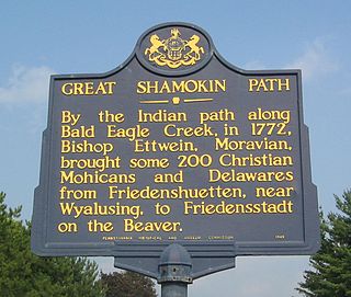
The Great Shamokin Path was a major Native American trail in the U.S. State of Pennsylvania that ran from the native village of Shamokin along the left bank of the West Branch Susquehanna River north and then west to the Great Island. There it left the river and continued further west to Chinklacamoose and finally Kittanning on the Allegheny River.

The Adam T. Bower Memorial Dam is the world's longest inflatable dam. The dam is located just below the confluence of the Western and Main Branches of the Susquehanna River, in Upper Augusta Township, between the town of Shamokin Dam and the city of Sunbury, Pennsylvania.
Fort Augusta was a stronghold in Northumberland County, Pennsylvania, in the upper Susquehanna Valley from the time of the French and Indian War to the close of the American Revolution. At the time, it was the largest British fort in Pennsylvania, with earthen walls more than two hundred feet long topped by wooden fortifications. With a garrison of over 300 troops and walls specially constructed to resist artillery, it presented a formidable defense and was never attacked. It served as a refuge for local settlers during the French and Indian War and during the American Revolutionary War. It was abandoned in 1780 and dismantled in 1796.

James Burd was a colonial American soldier in the French and Indian War, during which he played an important role in fortifying the Pennsylvania frontier.
Fort Halifax was located along the Susquehanna River near the present day borough of Halifax, Pennsylvania, United States. It was a temporary stronghold in northern Dauphin County, Pennsylvania, from 1756 to 1757, during the time of the French and Indian War.
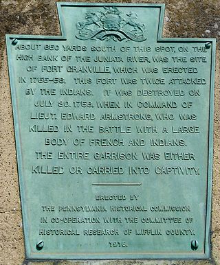
Fort Granville was a militia stockade located in the colonial Province of Pennsylvania. Its site was about a mile from Lewistown, in what is now Granville Township, Mifflin County. Active from 1755 until 1756, the stockade briefly sheltered pioneer settlers in the Juniata River valley during the French and Indian War. The fort was attacked on August 2, 1756, by a mixed force of French troops and Native Americans, mostly Lenape warriors. The fort’s garrison surrendered the strongpoint to these attackers, who celebrated their victory and destroyed the stockade.

Fort Shirley was a military fort located in present-day Shirleysburg, Pennsylvania. It was built in 1755 by George Croghan and later maintained by the Province of Pennsylvania during the French and Indian War. Fort Shirley was part of a defensive line of forts built in Pennsylvania during 1755 and 1756, at the start of hostilities with the French and their allied Native Americans. Although two French and Native American war parties were sent to capture it, Fort Shirley was never attacked. The fort served as the launching site for the Kittanning Expedition in September 1756, after which it was abandoned.
The Goschgoschink Path, later known as Mead's Path, begins at the junction of the Great Shamokin Path at The Big Spring near Luthersburg, Brady Township, Clearfield County, Pennsylvania. The path then proceeds to Thunderbird Spring, Sandy Valley Station, north of Reynoldsville, Jefferson County, thence through the Horme Settlement and slightly north of Emerickville to Brookville; north of Clarion, to West Hickory, Pennsylvania, in Forest County and the Allegheny River. From here, travelers could journey to Fort Le Boeuf and Lake Erie.

The Big Spring near Luthersburg, Brady Township, Clearfield County, Pennsylvania, was an important camp site and trail hub for the Great Shamokin Path and the Goschgoschink Path.
William Clapham was an American military officer who participated in the construction of several forts in Pennsylvania during the French and Indian War. He was considered a competent commander in engagements with French troops and Native American warriors, but towards the end of his military career he was unpopular with troops under his command. Following his retirement from the army, he and his family were killed by Lenape warriors on his farm in 1763.
Fort Dinwiddie (1755–1789) was a base for the Virginia Militia during the French and Indian War and Revolutionary War. It was located on the Jackson River, five miles west of Warm Springs, Virginia, in present-day Bath County.
The Northumberland County Historical Society is a Pennsylvania nonprofit organization, which was chartered on October 26, 1925 and incorporated on May 21, 1998. Its leaders, members and volunteers are dedicated to the collection, preservation and exhibition of artifacts, documents, photographs, and other items which tell the story of Northumberland County, Pennsylvania and its people.

Fort Vause was built in 1753 in Montgomery County, Virginia, by Ephraim Vause. The historic site is near the town of Shawsville, Virginia. It was attacked by French troops and Native American warriors in 1756, and most of the inhabitants were killed or taken prisoner. The fort was rebuilt in 1757 but abandoned by 1759.
Kuskusky, also known as the Kuskuskies Towns, Kuskuskie Towns, or Kuskuskies' Indian Town, with a wide variety of other spellings, were several Native American communities inhabited near New Castle, Mahoning, and Edinburg, Pennsylvania, and Youngstown, Ohio, during the mid-18th century. It was not one town, but three or four contiguous towns of the Mingoes, Lenape, and Seneca, located along the Beaver River, at and above the junction of its east and west branches, the Mahoning River and the Shenango River. It is usually referred to in the plural.
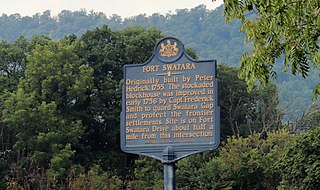
Fort Swatara was a stockaded blockhouse built during the French and Indian War in what is now Lebanon County, Pennsylvania. Initially a farmstead surrounded by a stockade, provincial troops occupied it in January 1756. The fort safeguarded local farms, but a number of settlers were killed by small Native American war parties. The fort was abandoned in May 1758.
Fort Hunter was a military fort located in present-day Fort Hunter, Pennsylvania. It was initially a stockaded gristmill fortified by Samuel Hunter in 1755 and later enlarged and maintained by the Province of Pennsylvania during the French and Indian War. Fort Hunter was part of a defensive line of forts built in Pennsylvania during 1755 and 1756, at the start of hostilities with the French and their allied Native Americans. It was briefly used during Pontiac's War, then abandoned in 1763.
Fort Henry was a stockade fort built in early 1756 in Berks County, Pennsylvania, to protect local settlers from Native American war parties, which were raiding the area frequently during the French and Indian War. It was one of the larger forts built in a defensive line, 12-20 miles apart, intended to safeguard the more densely-populated communities of the eastern Province of Pennsylvania. It was abandoned in 1759, and then briefly put back into use in 1763 during Pontiac's War.
References
- ↑ "The Bloody Spring". The Bucknell Environmental Center. Retrieved May 29, 2018.
- ↑ "The Bloody Spring Historical Marker". The Historical Marker Database. Retrieved May 29, 2018.
- ↑ Weslager, C. A. (1972). The Delaware Indians: A History. Rutgers University Press: News Brunswick, p. 231.
- ↑ "Bloody Spring". City of Sunbury, Pa. Retrieved May 29, 2018.